Ocean Newsletter
No.603 March 20, 2026
-
The Future Ocean Sleeping Beneath the Ice: A New World Opened Up by Antarctic RINGS
-
Carbon Cycle Study in the Southern Ocean and a Long-Standing Challenge
-
Arctic Challenge for Sustainability III (ArCS III)
-
The Northern Sea Route: Is the economic model viable?
The Future Ocean Sleeping Beneath the Ice: A New World Opened Up by Antarctic RINGS
KEYWORDS
Antarctic Ice Sheet / Polar Observation Strategy / Topographic Data Integration
MATSUOKA Kenichi (Senior Researcher, Norwegian Polar Institute)
Approximately half of the Antarctic Ice Sheet's basement lies below sea level, and ice sheet retreat due to global warming will lead to the emergence of new ocean areas. However, the large gaps in sub-ice sheet topography are one of the biggest uncertainties in future predictions. The Antarctic RINGS project, promoted by the Scientific Committee for Antarctic Research (SCAR) and the Council for Conducting Antarctic Research (COMNAP), is an international framework that is efficiently and strategically combining observational resources from various countries to fill in these gaps and explore the future ocean.
The “Future Ocean” Beneath the Ice
Antarctica is covered by the Antarctic Ice Sheet, the largest body of ice in the world, which in some places reaches a thickness of 4,000 meters and is thus called “the frozen continent.” However, the nature of the landforms and the “future ocean” that lie beneath this vast ice remain far from fully understood. Subglacial topographic maps have an extremely low resolution compared with those of other regions, making Antarctica one of the largest remaining data-gap areas on Earth.
A key factor linking subglacial topography to the “future ocean” lies in how the ice sheet is configured relative to the ocean. Approximately half of the Antarctic Ice Sheet rests on bedrock below sea level. As the ice thins due to warming, seawater can more easily penetrate into the deeper parts of the ice sheet (Fig. 1). As the ice retreats, vast areas that were previously covered by ice are exposed as a “future ocean.” In this sense, ice-sheet melt is also a process that creates new oceanic regions on Earth.
Furthermore, the primary driver controlling the behavior of the Antarctic Ice Sheet is not the atmosphere, but the ocean. Relatively warm deep water intrudes beneath the ice through submarine troughs on the continental shelf, enhancing basal melting. This process leads to the retreat of the grounding line, the boundary where the ice sheet begins to float, and becomes a key factor in determining the future position of coastlines. At present, ocean currents circulate around Antarctica and melt the ice along specific pathways. Each of these pathways will shape the configuration of the surrounding ocean regions hundreds of years into the future.
However, the primary limitation in understanding this critical process lies in the low resolution and limited accuracy of existing bed topographic maps (Fig. 2). This issue has been repeatedly identified in recent IPCC assessment reports as one of the largest factors driving uncertainty in ice‑sheet projections.
A key factor linking subglacial topography to the “future ocean” lies in how the ice sheet is configured relative to the ocean. Approximately half of the Antarctic Ice Sheet rests on bedrock below sea level. As the ice thins due to warming, seawater can more easily penetrate into the deeper parts of the ice sheet (Fig. 1). As the ice retreats, vast areas that were previously covered by ice are exposed as a “future ocean.” In this sense, ice-sheet melt is also a process that creates new oceanic regions on Earth.
Furthermore, the primary driver controlling the behavior of the Antarctic Ice Sheet is not the atmosphere, but the ocean. Relatively warm deep water intrudes beneath the ice through submarine troughs on the continental shelf, enhancing basal melting. This process leads to the retreat of the grounding line, the boundary where the ice sheet begins to float, and becomes a key factor in determining the future position of coastlines. At present, ocean currents circulate around Antarctica and melt the ice along specific pathways. Each of these pathways will shape the configuration of the surrounding ocean regions hundreds of years into the future.
However, the primary limitation in understanding this critical process lies in the low resolution and limited accuracy of existing bed topographic maps (Fig. 2). This issue has been repeatedly identified in recent IPCC assessment reports as one of the largest factors driving uncertainty in ice‑sheet projections.
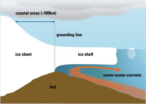
■ Figure 1. Schematic diagram of an ice shelf and the grounding-line region. Melting driven by warm water causes grounding-line retreat and can strongly affect the stability of the ice sheet, depending on the underlying bed topography. A detailed understanding of bed topography is therefore essential for understanding this process.
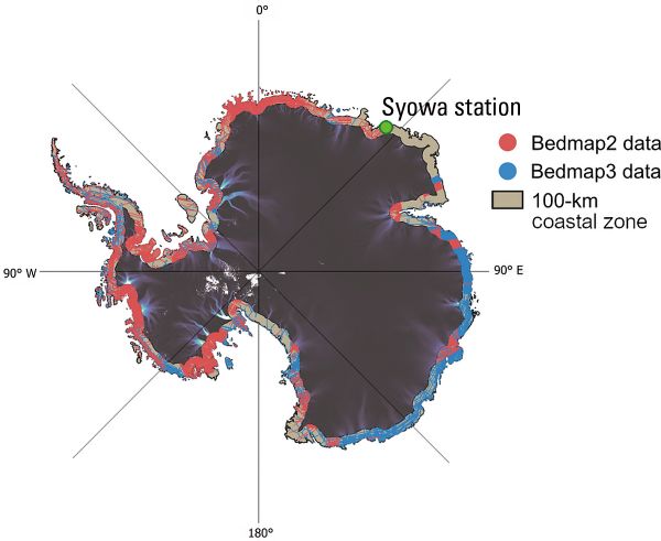
■ Figure 2. Distribution of subglacial topographic data within 100 km inland from the grounding line. Regions shown in red indicate data acquired between 1990 and 2010, while those in blue represent areas surveyed since 2010. Data density remains low across much of the region. In particular, areas east of Japan’s Syowa Station (40°E) constitute one of the most data-sparse regions in Antarctica. (Original figure source: Matsuoka et al., in review, Reviews of Geophysics, DOI: 10.22541/essoar.175241971.19851046/v1)
A New Model of International Collaboration Envisioned by Antarctic RINGS
International mapping initiatives toward understanding the subglacial environment are steadily progressing. Bedmap3, an Antarctic map released in 2025, represents the most comprehensive integrated model of subglacial topographic data compiled to date. At the same time, the International Bathymetric Chart of the Southern Ocean (IBCSO), which depicts seafloor topography in the Southern Ocean, is undergoing revision, and its latest datasets are already being used by researchers worldwide. IBCSO is a key component of the General Bathymetric Chart of the Oceans (GEBCO) program, a global seafloor mapping project that has received long-standing support from the Nippon Foundation. Japan’s contribution to the development of international infrastructure for visualizing the ocean floor has therefore been substantial.
However, both Bedmap3 and IBCSO are fundamentally designed to integrate existing datasets. As a result, no internationally coordinated mechanism has existed to collect, at a sufficient density and without gaps, the most basic and critical data: topographic information in the coastal regions of the ice sheet. Advances in satellite observations have enabled increasingly detailed monitoring of changes at the ice-sheet surface, and numerical models have seen remarkable improvements. In contrast, gaps in subglacial topographic data persist, as such data can only be obtained through airborne and ground-based observations. As a result, this limitation remains a bottleneck that constrains the accuracy of future projections.
Antarctic RINGS was established in response to this challenge (Fig. 3). The core mission of Antarctic RINGS lies not simply in “collecting data” itself, but in reconstructing the observation framework by internationally coordinating research vessels, aircraft, and research teams to strategically close data gaps. The framework divides the Antarctic Ice Sheet’s coastal sectors – the regions where the most rapid changes occur - into a series of “rings” with shared international responsibilities. In doing so, this framework transforms a mere accumulation of datasets into a synergistic leap through international collaboration.
However, both Bedmap3 and IBCSO are fundamentally designed to integrate existing datasets. As a result, no internationally coordinated mechanism has existed to collect, at a sufficient density and without gaps, the most basic and critical data: topographic information in the coastal regions of the ice sheet. Advances in satellite observations have enabled increasingly detailed monitoring of changes at the ice-sheet surface, and numerical models have seen remarkable improvements. In contrast, gaps in subglacial topographic data persist, as such data can only be obtained through airborne and ground-based observations. As a result, this limitation remains a bottleneck that constrains the accuracy of future projections.
Antarctic RINGS was established in response to this challenge (Fig. 3). The core mission of Antarctic RINGS lies not simply in “collecting data” itself, but in reconstructing the observation framework by internationally coordinating research vessels, aircraft, and research teams to strategically close data gaps. The framework divides the Antarctic Ice Sheet’s coastal sectors – the regions where the most rapid changes occur - into a series of “rings” with shared international responsibilities. In doing so, this framework transforms a mere accumulation of datasets into a synergistic leap through international collaboration.
■ Figure 3. Logo of Antarctic RINGS. The logo represents the project’s objective of circling over the coastal regions of the Antarctic Ice Sheet at least three times, primarily using aircraft. In practice, the three rings are divided by region, and observations are conducted in each area while coordinating coverage to ensure that no data gaps remain.
Unveiling the “Future Ocean”
Observations of the Antarctic continent, whose area is roughly 36 times that of Japan, cannot be carried out by a single nation alone. Central roles in promoting internationally coordinated observations are played by SCAR and COMNAP, and Antarctic RINGS is already advancing coordination within this existing framework. In addition, preparations have begun in anticipation of the Fifth International Polar Year (IPY) scheduled for 2032–33, and Antarctic RINGS is emerging as one of its key components.
In May 2026, the Antarctic Treaty Consultative Meeting (ATCM) will be held in Hiroshima. This meeting will provide an important opportunity for scientists, diplomats, and leaders of National Antarctic Programs from around the world to gather and discuss the future of Antarctica. Subsequently, in August of this year, the annual meetings of SCAR and COMNAP will be held in Norway, providing Antarctic RINGS with a valuable opportunity to deepen international cooperation.
Turning international cooperation into practical observations requires more than shared principles alone. To coordinate national observation plans and steadily carry out joint observations, sustained support that transcends national boundaries is indispensable. Just as efforts to visualize seafloor topography have greatly advanced international scientific cooperation, individual contributions in Antarctica can likewise lead to a much broader expansion of collaboration. In particular, the RINGS initiative in the Indian Ocean sector led by Norway is emerging as a pioneering effort. Rather than simply exchanging researchers, it is developing into an international joint project involving a total of ten countries, including Japan, by linking the support capabilities of research vessels, aircraft, and research stations. Preparations are also underway for large-scale airborne observations in the coming Antarctic field season, with Japan’s Syowa Station serving as a central hub. Such new seeds of cooperation are beginning to emerge in various regions. There is a growing need for a catalytic role to seamlessly integrate these initiatives and transform them into a stronger, collective force.
Interestingly, the concept underlying Antarctic RINGS itself is not new. In 1968, a proposal to observe Antarctica in a circumferential manner had already been presented at a conference held in Tokyo. Now, more than half a century later, this concept is beginning to seem more like a practical reality thanks to advances in technology and the maturation of international networks.
To understand the “future ocean,” sustained efforts that connect science, diplomacy, and international collaboration are essential. Positioned as a nexus for such efforts, Antarctic RINGS seeks to become a new pioneer that illuminates the future of Antarctic and bipolar research, including the Arctic.
In May 2026, the Antarctic Treaty Consultative Meeting (ATCM) will be held in Hiroshima. This meeting will provide an important opportunity for scientists, diplomats, and leaders of National Antarctic Programs from around the world to gather and discuss the future of Antarctica. Subsequently, in August of this year, the annual meetings of SCAR and COMNAP will be held in Norway, providing Antarctic RINGS with a valuable opportunity to deepen international cooperation.
Turning international cooperation into practical observations requires more than shared principles alone. To coordinate national observation plans and steadily carry out joint observations, sustained support that transcends national boundaries is indispensable. Just as efforts to visualize seafloor topography have greatly advanced international scientific cooperation, individual contributions in Antarctica can likewise lead to a much broader expansion of collaboration. In particular, the RINGS initiative in the Indian Ocean sector led by Norway is emerging as a pioneering effort. Rather than simply exchanging researchers, it is developing into an international joint project involving a total of ten countries, including Japan, by linking the support capabilities of research vessels, aircraft, and research stations. Preparations are also underway for large-scale airborne observations in the coming Antarctic field season, with Japan’s Syowa Station serving as a central hub. Such new seeds of cooperation are beginning to emerge in various regions. There is a growing need for a catalytic role to seamlessly integrate these initiatives and transform them into a stronger, collective force.
Interestingly, the concept underlying Antarctic RINGS itself is not new. In 1968, a proposal to observe Antarctica in a circumferential manner had already been presented at a conference held in Tokyo. Now, more than half a century later, this concept is beginning to seem more like a practical reality thanks to advances in technology and the maturation of international networks.
To understand the “future ocean,” sustained efforts that connect science, diplomacy, and international collaboration are essential. Positioned as a nexus for such efforts, Antarctic RINGS seeks to become a new pioneer that illuminates the future of Antarctic and bipolar research, including the Arctic.