Ocean Newsletter
No.575 July 20, 2024
-
Promoting Literacy in Ocean Dynamics through Offshore Drilling
-
Advances in Bathymetric Technology and Ocean Floor Geoscience
-
An Underwater Cultural Heritage Project in the United Nations Decade of Ocean Science
Advances in Bathymetric Technology and Ocean Floor Geoscience
KEYWORDS
Multibeam Bathymetry / Seafloor Topography / Data Disclosure
OKINO Kyoko (Professor, Atmosphere and Ocean Research Institute, The University of Tokyo)
The development of multibeam bathymetry has enabled detailed imaging of seafloor topography and has greatly advanced ocean floor geoscience. In the future, it is necessary to expand the survey to areas of the ocean that have not yet been surveyed, and at the same time to become able to track temporal topographic changes before and after volcanic eruptions and earthquakes, and to establish a system for making basic data available to the public.
60 Years of Multibeam Bathymetry
The multibeam sonar device, now standard for bathymetric surveys by vessels and AUVs (Autonomous Underwater Vehicles), originated from SAAS1, developed by the U.S. Navy in 1963. It marked its 60th anniversary in 2023. Its first use in Japan was on the Coast Guard survey vessel Takuyo in 1984, marking 40 years of use for the Japanese community. During this period, the swath width that can be measured at one time has broadened, and resolution has increased. At the same time, advancements in satellite geodetic technology have vastly improved position measurement accuracy, allowing for detailed seafloor conditions to be captured on par with land-based measurements.
Japan is surrounded by ocean trenches, which are the boundaries of converging plates2. For this reason, investigating subduction zones and volcanic island arcs is of great scientific interest and in high demand by society for disaster risk mitigation and resource exploration. Multibeam bathymetry first demonstrated its power around Japan's seas in 1983, when the French research vessel Jean Charcot surveyed the Japan Trench and Nankai Trough. The mid-oceanic ridge systems, which are plate divergence boundaries, were also mainly surveyed in the Atlantic and Pacific during the 80s and 90s, revealing one after another their structures and volcanic and fault activities. Alongside improvements in bathymetry equipment, computing was also increasing in power significantly, and by the mid-90s, it became possible to easily create three-dimensional displays and shading. These improvements had the effect of expanding the types of topographies recognizable through appropriate imaging even with the same numerical data (see figure).
Scientists tend to focus on active plate boundary areas, but knowledge about volcanic activity has also expanded. While hotspot volcanoes like Hawaii and their seamount chains have long been known, several large basalt plateaus are also known of on the seafloor. These were formed by large volumes of lava erupting over relatively short periods, and no similar igneous activity exists on Earth today. It is easy to imagine that such intense igneous activity would have significantly impacted the Earth's surface environment, leading to major events in earth history, such as mass extinctions and drastic changes in the material cycle. However, very few large oceanic plateaus are fully mapped. Conversely, very small new types of volcanoes have been discovered within plates. The Pacific Plate subducting beneath northeastern Japan at the Japan Trench is old, dating back 150 to 120 million years. However, Japanese researchers discovered new volcanic activities, albeit small in scale, near the outer rise (a gentle elevation formed by the elastic bending of the subducting plate) just before the plate subduction (Hirano et al., 2001, Science). These small volcano groups were named petit-spots and are now globally recognized as a form of intraplate volcanism. Surveying petit-spot distribution has been aided by backscatter intensity mapping using multibeam bathymetry. New lava is thinly deposited and has strong backscatter intensity, allowing it to be distinctly differentiated from the surrounding seafloor covered by older sediment despite being a very small dome.
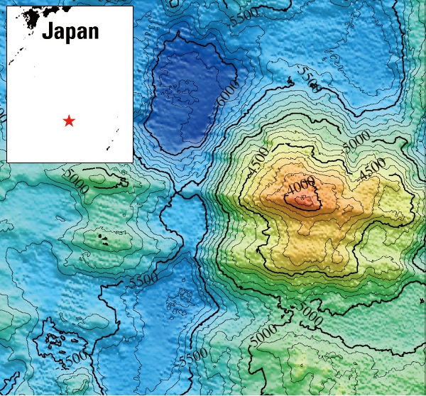
■ Figure: These topographic highs seen south of Japan are geological structures called oceanic core complexes. Even with the same numerical data, conventional contour maps made recognition difficult; however, with researchers now able to easily create shaded maps, discoveries have followed one after another.
The World of High-Resolution Surveys
The evolution of multibeam bathymetry has enabled a more realistic understanding of the seafloor's form. However, in deep-sea areas, the distance from the ship's bottom can reach several kilometers, resulting in frequencies in the 12 - 40 kHz range. The resolution obtained in standard surveys today is generally a 25 - 100-meter grid. However, with multibeam bathymetry equipment mounted on AUVs conducting surveys at altitudes of 80 - 100 meters above the seafloor at several hundred kHz, sub-meter micro-topographies can now be captured. This represents a significant advance in depicting the seafloor, allowing individual lava flows to be distinguished in submarine volcanoes. The actual states of the variation in the surface layer, such as submarine landslides, can also be understood with unprecedented accuracy. This equipment was particularly effective in seas around Japan when exploring submarine hydrothermal systems. The spread of hydrothermal vent areas on the seafloor is often about 100 meters square. In some cases, they are somewhat larger in island arc volcanoes like those in the sea near Japan, but regardless, they appear as point-like features from ship surveys. With the ability to explore at sub-meter scales, hydrothermal chimneys and collapsed surrounding sulfides can be distinguished, advancing the science of hydrothermal circulation systems and our understanding of the existence of hydrothermal deposits. Of course, AUVs are slower than vessels, and as their swath width is limited, comprehensive high-resolution mapping is not yet possible. In addition, satellite positioningcannot be used in the deep sea, so there are still issues with positional accuracy. However, uncrewed vehicles are expected to have longer autonomous navigation times in the future, and with ongoing technological developments aimed at improving positioning, the next generation is expected to achieve widespread high-resolution mapping in the deep sea.
Tracking Changes Over Time
According to reports from the SeaBed20303 project, which aims to comprehensively map the seafloor of Earth using multibeam bathymetry, less than 30% of the seafloor is mapped at the target resolution as of 2023. There is still a vast, uncharted world out there. Meanwhile, another important future direction is observing changes to the seafloor over time. In the aftermath of the 2011 Tohoku earthquake, research results reported that the seafloor in the epicentral area moved about 25 meters horizontally due to the earthquake (Fujiwara et al., 2011, Science). This groundbreaking result showed seafloor changes by seismic fault solely through bathymetric measurement. It was achieved by conducting multibeam bathymetry near the epicentral area about ten days after the earthquake and comparing it with pre-earthquake multibeam bathymetric data from the same measurement lines. Such results were possible because good accuracy observation data (both positioning and bathymetry) existed before the earthquake, which cannot be achieved by surveying only after an earthquake occurs. Incidentally, 1998 was when stable use of GPS-based vessel positioning began, and data from before this period would likely face challenges in comparison due to positional accuracy issues. Beyond seismic changes in trench regions (earthquake faults, slope failures, etc.), for coastal active fault areas and submarine volcanoes along the Izu-Ogasawara arc and Okinawa islands, having baseline data during tranquil periods is crucial for revealing the nature of seismic activity, rather than just surveying after eruptions or earthquakes occur. In the case of the Noto Peninsula earthquake on January 1, 2024, surveys conducted by Japan Coast Guard's Hydrographic and Oceanographic Department reported a 3-meter seafloor uplift and large-scale slope collapse in a submarine canyon, which is believed to have occurred at the earthquake4. For the Noto Peninsula offshore and Toyama Bay, there are areas with and without high-quality pre-earthquake data, so comparisons were not possible across the entire epicentral area. While vessel-based bathymetry in areas surrounding Japan is essentially complete through continental shelf surveys, high-resolution baseline data collection is needed for significant marine areas. Additionally, although water depth data has historically been treated as confidential, it is essential information for all maritime surveys and research, and a system for broad public disclosure is also necessary.
1. Sonar Array Sounding System
2. Plate convergence boundaries are boundaries where plates come together (plate divergence boundaries are where they move apart)
3. https://seabed2030.org/
4. https://www.kaiho.mlit.go.jp/info/kouhou/r6/k240208/k240208.pdf and https://www.kaiho.mlit.go.jp/info/kouhou/r6/k240222/k240222.pdf
2. Plate convergence boundaries are boundaries where plates come together (plate divergence boundaries are where they move apart)
3. https://seabed2030.org/
4. https://www.kaiho.mlit.go.jp/info/kouhou/r6/k240208/k240208.pdf and https://www.kaiho.mlit.go.jp/info/kouhou/r6/k240222/k240222.pdf