I would like to examine the wide-spread damage caused by the massive tsunami during the 201 Great East Japan Earthquake as well as introduce unprecedented forms of damage such as the black tsunamis. Academic studies aiming for future disaster preparedness based on practical research have commenced and are producing results. As memories and experiences fade away in the 10 years after the earthquake and tsunami, I would like to introduce activities to pass on experiences and lessons by networking the affected areas.
Selected Papers No.27(p.6)
Ocean Newsletter
No.494 March 5, 2021
PDF
3MB
-
10 Years After the Great East Japan Earthquake: Our Experiences and Lessons to be Passed Down
-
Reconsideration of the Coastal Management from the viewpoint of Ecosystems Affected by the Great East Japan Earthquake
-
Mirai Ships Inc. Clears the Way to 100 Years into the Future
10 Years After the Great East Japan Earthquake: Our Experiences and Lessons to be Passed Down
I would like to examine the wide-spread damage caused by the massive tsunami during the 201 Great East Japan Earthquake as well as introduce unprecedented forms of damage such as the black tsunamis. Academic studies aiming for future disaster preparedness based on practical research have commenced and are producing results. As memories and experiences fade away in the 10 years after the earthquake and tsunami, I would like to introduce activities to pass on experiences and lessons by networking the affected areas.
The Great East Japan Earthquake
The earthquake that struck off the Pacific coast of the Tohoku region (at around 14:46 on March 11, 2011) was named the “2011 off the Pacific coast of Tohoku Earthquake” by the Japan Meteorological Agency, and eventually became known as the Great East Japan Earthquake. It was the largest earthquake in Japan’s recorded history. The tsunami that struck immediately afterward impacted a vast area, causing tremendous damage to the coast and other areas. It was a widespread, complex event involving a chain of disasters which followed the earthquake itself, including the tsunami, liquefaction, landslides, fires, and the nuclear power plant accident, which resulted in damage never before experienced by humankind. It was given various names in Japan in its aftermath, such as the Great Tohoku-Kanto Earthquake, the Massive East Japan Earthquake, and the Great 3.11 Earthquake. However, the convention most commonly used in Japan is the Great East Japan Earthquake, or Higashi Nihon Daishinsai. This paper will focus on the actual conditions of the damage caused by the tsunami, as well as the initiatives to ensure that the experiences and lessons learned from the disaster are passed on.
Damages Caused by the Megatsunami: Unprecedented Type of Damage
The megatsunami and the damages recorded on pictures and videos at that time were overwhelming. The damage it caused was more extensive and complex than we can imagine. However, this damage can be categorized into triggers and predisposing factors, which are useful for producing effective countermeasures and responses to future disasters.
Although tsunamis in and of themselves are just seawater, their impacts are diverse, with more pronounced damage seen in coastal areas. Typically, triggers are natural forces that cause disasters (the damage and impact). Predisposing factors are classified into natural factors related to the earth’s surface, such as topography and ground conditions, and social factors related to people and society, such as population, buildings, and facilities.
As summarized in Table 1, triggering factors for tsunamis include inundation and flooding, as well as currents and wave forces. Predisposing factors are the seafloor and land topography, land use patterns, and protective facilities. This table also summarizes significant impacts and damage reported after the earthquake. Damage caused by seawater inundation has been seen in the past. However, the increased destructive power of the current was accompanied by the production of floating debris, which increased the scale of damage and topographical changes.
The earthquake produced a black tsunami (containing pollution). There have been reports of building damage and health problems related to this event, with the damage being especially pronounced in coastal urban areas. This is because mud and sand from the seafloor were swept up by the tsunami and deposited onto the land as sediment. The seawater became viscous when the mud was incorporated, increasing the gradient of the wave’s leading edge, and increasing the wave force as a result.
This phenomenon also caused health effects such as tracheal obstruction from swallowing the muddy water, and tsunami lung from the inhalation of dust after the mud dried. Future measures are necessary in order to cope with these new types of damage.
Table 1: Tsunami triggers, predisposing factors, and impact/damage
| Triggers | Predisposing Factors | Examples of Impact/Damage |
|---|---|---|
| Inundation/Flooding | Seafloor and Coastal Topography, Combustibles, Land Use Patterns, Protection Level, Awareness of Evacuation |
Human Casualties (Primarily Drowning), Dry Vegetation due to Sea Water, Agricultural Damage, Tsunami-Related Fires (Ignited by Power Lines, Batteries, etc.) |
| Current and Wave Force (Tractive Force) | Coastal Topography, Soil and Sediment, Debris, Infrastructure, Land Use Patterns |
Damage to Houses/Facilities, Infrastructure Damage, Flooding and Inundation of Buildings/Structures, Erosion/Sedimentation (Topographical Changes), Environmental/Ecological Destruction |
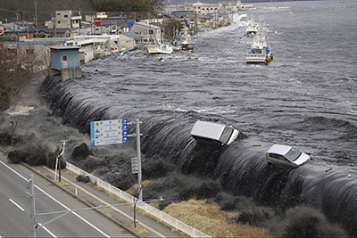 The black tsunami as witnessed in Miyako City
Interdisciplinary Research to Produce Practical Benefits: Preventing Another 3.11
Tohoku University launched the International Research Institute of Disaster Science just one year after the Great East Japan Earthquake. The institute combines wisdom from the humanities, science, and medicine, thereby aiming to solve the challenges experienced after the disaster. It has been established as an organization that strongly promotes world-leading scientific research related to natural disaster science. Here, they have developed a system for utilizing the lessons learned from the disaster by treating series of responses to the disaster as a single cycle, organizing examples and issues into pre-disaster, during, and recovery/reconstruction phases. New forms of collaborative, interdisciplinary research have also produced results. These results do not stop at recovery and reconstruction support in the affected areas; they also help promote practical methods of preparing for future disasters. The disaster was both complex and unprecedented, and as its effects are still ongoing, there is some uncertainty about precisely what the final impact will be. However, interdisciplinary research reveals precisely what we don’t know while exploring factors essential for future disaster risk reduction and mitigation.
Researchers from different fields come together at the institute to combine their disciplines. This fusion resulted from promoting practical research; it wasn’t one of the institute’s original aims. The idea of combining research into tsunamis, earthquakes, and landslides as natural phenomena while exploring past earthquakes and tsunamis through examining ancient documents and collaborating with historical experts is not new. However, significant changes have occurred since the earthquake. A unified examination of aspects such as historical background, topography, and land use, in addition to historical documents, has provided more clarity regarding the actual damage that occurred. Experts from other fields are also being brought together to provide various perspectives. These actions have enabled quantitative scientific evaluations of these past disasters.
The Network’s Role in Bringing Together Geographically Separate Facilities
The experiences and lessons learned from the Great East Japan Earthquake must not be forgotten. For this purpose, it is vital to draw attention to the various kinds of information and initiatives related to disaster risk reduction, recovery, and reconstruction. This goal can be achieved by utilizing networks of memorial facilities and activities related to the earthquake. Memorial facilities include building remains and exhibition facilities that teach people about the actual situation and lessons learned from the disaster. However, it isn’t easy to visit all of these facilities and gather information from them in a limited amount of time, as they are scattered over a vast area that spans several prefectures. It is, therefore, necessary to categorize these facilities and their information, creating a network between them by installing guide maps and signs. This action ensures visitors can efficiently visit and tour the facilities depending on their aims and available time. One of the organizations formed in response is the 3.11 Densho Road Promotion Organization (https://www.311densho.or.jp/en/), which is developing maps and signs to create a network of registered memorial facilities*. The facilities and networks will serve as a base for various initiatives that are being planned on learning and preparedness related to disaster risk reduction and mitigation, as well as tsunamis. These activities are expected to contribute to the formation of a disaster-resilient society and the revitalization of local communities by improving knowledge and awareness of disaster risk reduction and promoting exchange between people across different regions and nations. (End)
- *Map of 3.11 Densho Road
https://www.311densho.or.jp/en/introduction/index.html?no=0