Ocean Newsletter
No.593 May 20, 2025
-
Umi-no-Chizu (Map of the Sea) Project: Towards the Reconstruction of Noto
-
Current Status and Challenges of Ocean Visualization
-
Digital Transformation of the Ocean and Beyond
Umi-no-Chizu (Map of the Sea) Project: Towards the Reconstruction of Noto
KEYWORDS
Noto Peninsula Earthquake / Seafloor Topography / Fisheries
KATO Shigeru (President of the Japan Hydrographic Association)
The Nippon Foundation and the Japan Hydrographic Association have been promoting the Map of the Sea Project since 2022, using ALB (airborne Lidar Bathymetry) to map the shallow waters off the coasts of Japan. As part of this project, we were able to conduct surveys in the northern coastal areas of the Noto Peninsula both before and after the Noto Peninsula earthquake of January 2024. These surveys were the first in the world to successfully obtain detailed seafloor topography data in coastal shallow waters before and after an earthquake accompanied by a large uplift. Furthermore, we conducted additional surveys in some coastal areas after the heavy rain disaster in September of the same year. It is our hope that these results will help with the reconstruction of Noto.
Survey of Northern Noto Peninsula
The “Map of the Sea Project” * is a project carried out by the Nippon Foundation and the Japan Hydrographic Association. Launched in 2022 with a 10-year plan, the project aims to develop seafloor topography maps of shallow water areas along approximately 90% of Japan's coastline, which spans about 35,000 km. This project uses airborne lidar bathymetry systems to target shallow water areas from land to approximately 20 meters depth (or deeper, depending on water clarity). While seafloor topographic surveys in marine areas are usually conducted using sonar from vessels, the use of airborne lidar bathymetry in shallow waters significantly improves survey efficiency compared to ship-based methods and enables the collection of continuous topographic data from land to sea. The “Map of the Sea” obtained through this survey are organized with a 50cm grid size, creating an unprecedented high-precision dataset of the sea. This comprehensive approach to developing seafloor topographic maps of shallow water areas off the coasts of Japan is the first of its kind in Japan. The survey began in August 2022, and have been conducted along the Pacific coast from the Tohoku region to Shikoku, in the Seto Inland Sea, and along the Hokuriku region. By the end of 2024, the project had surveyed 25% of Japan’s coastline indicating smooth progress .
As part of this project, surveys were conducted in northern Noto Peninsula from September to October 2022. Subsequently, the Noto Peninsula Earthquake occurred in January 2024, causing significant coastal uplift and exposing wide areas of seabed along the coastline. In addition, the seabed in shallow waters also experienced similar uplift, and major changes in the seafloor topography were anticipated. Therefore, a follow-up survey was conducted from April to May 2024 after the earthquake. These two surveys enabled a comparison of seafloor topographic maps from before and after the Noto Peninsula Earthquake. Furthermore, in September of the same year, heavy rainfall concentrated in the northern part of the Noto Peninsula, causing river flooding and landslides, and leading to a large-scale outflow of sediment into the surrounding seafloor. As further changes in seafloor topography were anticipated, additional surveys were conducted in certain marine areas in October 2024.
As part of this project, surveys were conducted in northern Noto Peninsula from September to October 2022. Subsequently, the Noto Peninsula Earthquake occurred in January 2024, causing significant coastal uplift and exposing wide areas of seabed along the coastline. In addition, the seabed in shallow waters also experienced similar uplift, and major changes in the seafloor topography were anticipated. Therefore, a follow-up survey was conducted from April to May 2024 after the earthquake. These two surveys enabled a comparison of seafloor topographic maps from before and after the Noto Peninsula Earthquake. Furthermore, in September of the same year, heavy rainfall concentrated in the northern part of the Noto Peninsula, causing river flooding and landslides, and leading to a large-scale outflow of sediment into the surrounding seafloor. As further changes in seafloor topography were anticipated, additional surveys were conducted in certain marine areas in October 2024.
Topographic Changes Before and After the Earthquake
The survey conducted in 2022 covered the outer coast of the Noto Peninsula, known as Sotoura (from Shika Town in Hakui District to Misaki Town in Suzu City), spanning a total distance of approximately 225km of seafloor, ranging from depths of 0 to about 20 meters. This area closely matched the coastal region that experienced the uplift of the 2024 Noto Peninsula Earthquake. After waiting for the flight restrictions on civilian aircraft to be lifted, follow-up surveys were carried out in this marine area from April to May 2024. Analysis of the bathymetric data (point clouds) obtained from these surveys was conducted to detect three-dimensional topographic movement. As a result, in the vertical direction, it was found that the seabed near Cape Saruyama in the northeastern part of the Noto Peninsula had uplifted by approximately 5.2m. This amount of uplift exceeded the maximum uplift of 4.1m reported on land. In the horizontal direction, it was found that the area from Shimizu Town to Nagahashi Town in Suzu City shifted by an average of approximately 2.5m, with a maximum of 4.3m, in a west-northwest to northwest direction. Additionally, the area from Cape Saruyama to around Kaiso fishing port shifted by approximately 2.2m on average, with a maximum of 3.0m, in a west to west-southwest direction. These displacement amounts were generally consistent with the crustal deformation already confirmed on land. According to expert consultations conducted by the Japan Hydrographic Association, this was the world's first successful analysis of crustal deformation in coastal shallow water areas before and after a major earthquake with significant uplift like the Noto Peninsula Earthquake.
Furthermore, detailed analysis of the seafloor topography revealed that the uplift was not uniformly distributed across the entire area. Figure 1 shows the topographic changes before and after the earthquake along the coastal area of MonzenKuroshima Town, Wajima City. Due to the significant uplift caused by the earthquake, the coastline shifted approximately 200m offshore, greatly expanding the beach area. Additionally, on the seafloor, substantial sediment displacement occurred, and new rock reefs emerged in places that were previously sandy. The sediment movement is thought to have been caused by the influence of wave action and tidal currents after the water depth became shallower due to the earthquake.
In addition, follow-up surveys were conducted again in some marine areas after the heavy rainfall that struck the northern Noto Peninsula in September 2024. Figure 2 compares the topography before and after the heavy rainfall near Osawa Port in Wajima City. In the May survey conducted prior to the heavy rainfall, a considerable area within the port had turned into land due to uplift caused by the earthquake. However, in October, following the heavy rainfall, it was confirmed that sediment discharged from rivers had completely filled the port, and also buried the submarine valley beyond under a large volume of sediment.
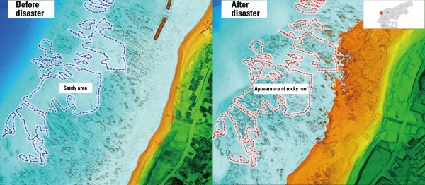
■Figure 1: Topographic changes before and after the earthquake (near Kuroshima Town, Monzen Town, Wajima City)
Before Noto Peninsula earthquake (September 2022) / After Noto Peninsula earthquake (May 2024)
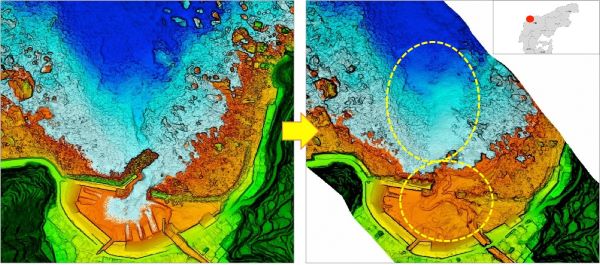
■Figure 2: Topographic changes before and after heavy rainfall (Osawa Port, Wajima City)
Before heavy rainfall (May 2024) / After heavy rainfall (October 2024)
Hope for Reconstruction
The ecosystem in shallow water areas along the northern coast of Noto Peninsula suffered devastating damage due to the earthquake and heavy rainfall. However, not everything was lost. The post-earthquake survey confirmed the appearance of new rocky areas. The “Map of the Sea” of the northern Noto Peninsula may provide clues for finding new rocky reefs where seaweed beds might form, or rocky reefs with seaweed beds which have previously been unrecognized. The “Map of the Sea” has the potential to provide information about rocky reefs that could become new fishing grounds, offering hope for the recovery of local coastal fisheries.
Furthermore, due to the uplift of the seafloor, fishing vessels and other coastal vessels are being forced to navigate offshore for safety. But the existence of the “Map of the Sea” will likely enable safer navigation even in coastal water. It will also contribute to more efficient surveys aimed at locating new seaweed beds. Additionally, heavy rainfall disasters caused road disruptions due to landslides. “The Map of the sea” can contribute estimating maximum wave height based of the detailed seafloor topography data, which is necessary for coastal protection works, as part of reconstructing roads.. In addition, restoring fishing ports requires not only ensuring safety within the ports themselves but also providing the safety of waterways for fishing boats. The “Map of the Sea” will also be useful for these restoration efforts. Furthermore, it is expected to enhance the accuracy of tsunami simulations, contributing to future disaster preparedness.
We hope that the latest seafloor topography information revealed by the “Map of the Sea Project” will contribute to the future reconstruction of the Noto region, particularly in supporting coastal fisheries.
*Umi-no-Chizu Project: https://www.nippon-foundation.or.jp/what/projects/umichizu