Ocean Newsletter
No.591 March 20, 2025
-
The Birth of the International Organization for Marine Aids to Navigation (IALA) ~For the development of aids to navigation around the world~
-
UK Maritime Policy and its Implications for Japan -Responses and challenges to autonomous ships-
-
Supporting the Safe Operation of Ships
-
Coastal Area Safety -10 Years After the Sendai Framework for Disaster Risk Reduction-
Coastal Area Safety -10 Years After the Sendai Framework for Disaster Risk Reduction-
KEYWORDS
Coastal Disaster Prevention / Climate Change / Population Decline
SATO Shinji (Dean, Graduate School of Engineering, Kochi University of Technology)
After the Great East Japan Earthquake, tsunami countermeasures advanced with the goal of "protecting human lives at all costs." This was realized through setting two levels of tsunami prevention measures, publicizing flood predictions, establishing temporary evacuation facilities, and constructing embankments using private capital. In the future, climate change and population decline are expected to progress further, increasing the vulnerability to disasters, particularly in rural coastal areas. For future coastal disaster prevention, it is important to internalize these external factors and examine them in an integrated fashion.
Tsunami Countermeasures Aimed at Protecting Human Lives at All Costs
2025 is a milestone year, marking 30 years since the Great Hanshin-Awaji Earthquake and 10 years since the establishment of the Sendai Framework for Disaster Risk Reduction following the Great East Japan Earthquake. The "Sendai Framework for Disaster Risk Reduction 2015-2030" is an international disaster reduction guideline, succeeding the "Hyogo Framework for Action" adopted in 2005, with the goal of significantly reducing disaster damage by 2030. To achieve this objective, four priority actions have been established, including "understanding disaster risks" and "strengthening disaster risk governance," with concrete initiatives being implemented worldwide. This article will focus on coastal disaster prevention, the author’s specialty, reviewing Japan's efforts over the past 10 years since the framework's adoption and looking ahead to challenges through 2050.
The 2011 off the Pacific Coast of Tohoku Earthquake that occurred on March 11, 2011, caused widespread damage through a magnitude 9 earthquake and tsunami originating from the Japan Trench. Subsequently, new tsunami countermeasures were developed by dividing strategies into two levels: Level 1, which aims to prevent tsunami entry through coastal structures like seawalls, and Level 2, which focuses on addressing the impact through land use strategies such as relocating settlements to higher ground and ensuring early evacuation. This two-stage external force setting is considered an extension of the concept originally introduced to address earthquakes after the Great Hanshin-Awaji Earthquake, now applied to tsunami disasters. For Level 2 tsunamis, as flooding damage cannot be completely avoided, the approach combines residential relocation and early evacuation strategies to minimize damage and implement measures that will "protect human lives at all costs."
Among the most effective measures for "protecting human lives at all costs" are the publication of flood inundation projection maps, installation of temporary evacuation facilities, and construction of large-scale embankments. Tsunami flood inundation projections have become highly precise nationwide due to advances in numerical calculation techniques. Publishing these maps has improved coastal residents' disaster awareness and enabled concrete support, such as residential site selection and urban planning. During the Noto Peninsula Earthquake on January 1, 2024, many residents who evacuated early were aware of tsunami inundation areas, which may have been a factor in significantly reducing human casualties from the tsunami. Flood inundation projection maps indicate both the height of tsunamis and the arrival time. In coastal lowlands where tsunamis can arrive rapidly and there is little high ground nearby, temporary evacuation towers and artificial elevated grounds, called 'inochi-yama' (mountain of life), have been constructed, and many areas have reached a situation where they can almost completely accommodate temporary evacuees. Figure 1 depicts a tsunami evacuation tower in Kuroshio Town, Kochi Prefecture. Completed in 2017, it is a 25-meter-tall steel structure designed to shelter 230 people.
In coastal lowlands with vast areas and concentrated populations, it becomes more practical to construct high embankments on the land side of coastal barriers to mitigate flood damage, rather than building numerous evacuation towers. This approach helps delay tsunami intrusion and provide additional evacuation time.
Coastal levees are designed to withstand Level 1 tsunamis and are constructed by prefectural coastal management authorities. High-embankment levees are disaster mitigation facilities designed to withstand tsunamis exceeding Level 1, and under the current legal framework, financially constrained municipalities are responsible for their construction. In Hamamatsu City, Shizuoka Prefecture, a high-embankment levee approximately 13 meters high and 17.5 kilometers long, as shown in figure 2, was completed in 2020, funded by donations from private companies whose business premises are located in the anticipated inundation zone. A famous example of utilizing private capital for disaster infrastructure is the embankment in Hiromura (currently Hirokawa Town, Arida District) in Wakayama Prefecture. Hamaguchi Goryo*1, a local asset holder who witnessed the damages of the Ansei Nankai Earthquake, invested his personal fortune in embankment construction, which is said to have helped mitigate tsunami damage during the Tonankai and Nankai Earthquakes of the Showa era. In addressing low-frequency disasters such as Level 2 tsunamis, it is vital to sustain local disaster awareness for hundreds of years. Therefore, local residents' participation in disaster prevention activities and leveraging private investment are becoming increasingly important.
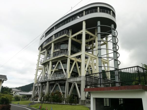
■Figure 1: Tsunami Evacuation Tower in Kuroshio Town, Kochi Prefecture
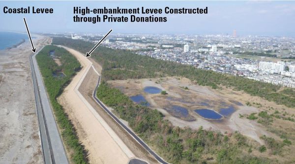
■Figure 2: High-embankment Levee Constructed in Hamamatsu City, Shizuoka Prefecture (Provided by Shizuoka Prefecture)
Population Decline, Climate Change and Coastal Disaster Prevention Toward 2050
Delays in recovering from the 2024 Noto Peninsula Earthquake are presenting a significant challenge. In the same region, an extraordinarily heavy rainfall occurred approximately 9 months after the earthquake, with landslide and flooding damages adding further devastation. It has been pointed out that this, along with significant population outflow from the area, has greatly impacted the reconstruction efforts. While the immediate triggers of the disaster were seismic activity and tsunami inundation, the example demonstrates that the slow reconstruction is the result of combined effects, including an increase in abnormal heavy rainfall due to climate change and societal structural changes caused by population decline. In Kochi, where the author lives, measures to prepare for the Nankai Trough Earthquake have been meticulously examined, but the focus remains primarily on direct hazard responses. In the coastal areas of outlying regions, secondary impacts of climate change and population decline are likely to be key factors contributing to the prolongation of disasters and reconstruction efforts.
Disaster risk can be assessed through three elements: "Hazard," "Exposure," and "Vulnerability." In tsunami disasters, the risk is greater when the tsunami (hazard) is larger, the population and assets at risk (exposure) are more significant, and countermeasures are less developed (vulnerability). As population decline progresses, the exposed population in the region decreases, which reduces risk, but at the same time, disaster prevention investment stagnates and the community that is to generate 'mutual assistance' weakens, increasing vulnerability. As a result, risk often increases.
Nationwide examinations of climate change impacts are ongoing with the goal of developing coastal conservation plans that incorporate these considerations by the end of fiscal year 2025. Due to meteorological changes affecting waves and tide levels, these factors are subject to examination. However, in actual beaches, changes in waves and tide levels can significantly alter the topography, so future topographic changes will need to be considered. In coastal areas, when sea-level rises due to global warming, the impact extends not only to areas near the coastline, but to a "wide area" offshore, resulting in the movement of large amounts of sediments over a wide range. If the total sediment amount of the coast remains unchanged, the relationship between coastline recession and sea-level rise will be the same as the relationship between the vertical height and horizontal distance ratio (average gradient) of this wide area. For instance, assuming a 40 cm sea-level rise by the end of the 21st century under the RCP-2.6*2 scenario, and considering that most beaches have an average gradient of 1/50 to 1/100, the coastline recession can be estimated at 20-40 meters by dividing the amount of sea-level rise by the average gradient. Such beach reduction increases the risk of land inundation, and therefore must be included in planning while acknowledging the inherent uncertainties.
Coastal area safety has traditionally been examined based on predictions of tide levels, waves, and tsunamis. However, in considerations towards 2050, which will follow the "Sendai Framework for Disaster Risk Reduction 2015-2030," population decline and climate change impacts will also become more dominant factors. It is important to internalize what were previously considered external factors, and examine them in an integrated fashion. Under conditions where predictions are uncertain, there is a need to choose flexible disaster prevention measures that allow the selection of optimal responses.
*1 Reference: Koichi SAKIYAMA, "The Fire of Rice Sheaves and its Connection to World Tsunami Awareness Day," No. 414 (Published on November 5, 2017) https://www.spf.org/opri/newsletter/414_1.html
*2 RCP (Representative Concentration Pathways): A scenario (assumption) used for future global warming predictions. RCP-2.6 refers to a low stabilization scenario that aims to limit global warming to 2°C.
*2 RCP (Representative Concentration Pathways): A scenario (assumption) used for future global warming predictions. RCP-2.6 refers to a low stabilization scenario that aims to limit global warming to 2°C.