Ocean Newsletter
No.582 November 5, 2024
-
Digital Archives of the Ocean and Disasters
-
The Chair that Looked Out at the Sea - Thinking about the reconstruction of Sanriku from the origins of fishing village culture
-
Disaster Prevention Tradition Efforts Using the Shikoku Disaster Prevention 88 Tales Map
-
Ocean Health Checklist and Japanese Coastal Ocean Monitoring and Forecasting System
-
Changes in Typhoons Hitting Cities: Recent typhoon damage and new trends in disaster prevention measures
Digital Archives of the Ocean and Disasters
KEYWORDS
Sea Level Rise / Tsunami / Disaster
WATANAVE Hidenori (Professor, Graduate School of Interdisciplinary Information Studies, The University of Tokyo)
We have worked with local people to create digital archives on disasters related to the ocean, such as rising sea levels and the threat to our land due to global warming, as well as the tsunami caused by the Great East Japan Earthquake. This article explains these cases.
Tuvalu, an isolated island nation in the Pacific Ocean and rising sea levels
Mankind has had a close relationship with the sea since ancient times. The sea brings abundant harvests and supports the lives of living beings, including ourselves, but it can also be life-threatening and can steal lives. We have worked with local people to create digital archives on disasters related to the ocean, such as rising sea levels and the threat to our land due to global warming, as well as the tsunami caused by the Great East Japan Earthquake.
Digital archives have great significance. They can convey to the world the words of people exposed to ongoing calamities or help pass on to the future memories from major disasters, encouraging society to take action. They are vital tools for utilizing lessons from the past and strengthening preparations for future disasters.
Nowadays, information about remote regions can easily be obtained via the internet. However, the internet tends to be dominated by sensational information like major accidents and disasters, making it difficult to convey the multifaceted realities of remote areas. This situation hinders our understanding of the people and culture living in these remote areas. Tuvalu is a prime example of this issue, which is at risk of becoming submerged due to rising sea levels caused by global warming. It has recently been the subject of many news reports, and its image as a “tragic nation” is becoming established. However, it is difficult to convey the lives and feelings of the people living there and to form an accurate picture of Tuvalu's reality. In response to this situation, the nonprofit organization Tuvalu Overview began the 10,000 Faces Project, promoting activities to convey the lives and culture of Tuvalu's people.
In collaboration with Tuvalu Overview, we launched the Tuvalu Visualization Project[1]—a digital archive—in 2009 and have continued to manage it ever since. The project captures the reality of this remote region through comprehensive presentation of people's portraits and scenes from their daily lives. It aims to convey Tuvalu’s reality using digital technology, to foster a sense of solidarity through online communication, and to create opportunities to reaffirm regional issues on a global scale. The project provides portraits and interview records of people living in Tuvalu on a digital globe, allowing users to view them in the context of where these people live (Figure 1). Additionally, users can send comments to people in Tuvalu. When they do, lines of light are drawn between the user's location and portrait, displaying the history of their communication (Figure 2). This visualizes the global spread of communication created by people who have connected with Tuvalu.
The project helps convey Tuvalu's reality in a multifaceted manner, going beyond sensational information to share real perspectives and feelings from its people with others worldwide, providing a means to understand them as they relate to their daily lives. It promotes recognition of problems in remote areas on a global scale and helps prompt responses from throughout society.
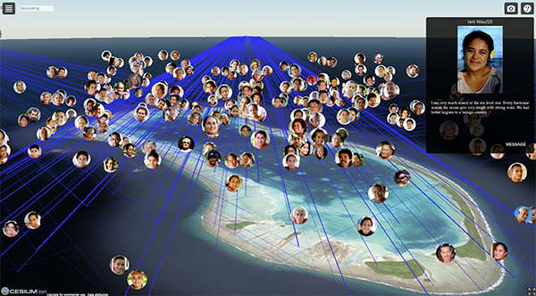
■Figure 1: Portraits of people in Tuvalu and interview records
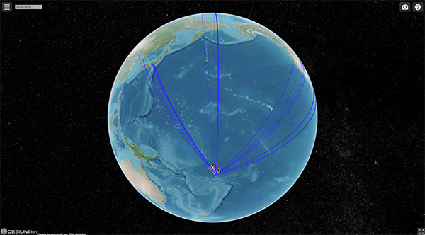
■Figure 2: A history of communication drawn on a digital globe
The Victims of the Great East Japan Earthquake and Tsunami
In March 2016, to mark the 5th anniversary of the Great East Japan Earthquake, my research team, working with Iwate Nippo Newspaper, produced and released the digital archive “We Shall Never Forget - Last Movements of Tsunami Disaster Victims”[2], which summarizes how victims attempted to evacuate. The archive overlays their evacuation behavior on aerial photographs and maps taken immediately after the earthquake, and an animation recreates the behaviors of 1,326 people for whom detailed data was available. It also provides records of behaviors and names of 687 victims (Figure 3). The project aims to convey the voices of the victims to future generations, creating lessons that aim to save as many lives as possible.
In addition, Iwate Nippo explored new possibilities for the medium of newspapers by analyzing the evacuation behaviors and making proposals using this archive. In a behavioral analysis of 2,135 victims, it was revealed that in the case of the Great East Japan Earthquake many lives were lost not only by staying at home or evacuating too late but also by gathering at evacuation centers. Visualizing this data on a map makes assessing an overall image of evacuation behaviors easier. Furthermore, aerial photography data from the Geospatial Information Authority of Japan also allows comparison of aerial photographs taken immediately after the earthquake with those taken in the past. This allows for a visual understanding of the pre-and post-disaster situations. Since this archive is accessible to anyone worldwide, it is also expected to serve as a means to share lessons from the earthquake internationally. This data may useful for reference in tsunami-affected areas, particularly in the Pacific Rim region.
For the 10th anniversary of the Great East Japan Earthquake in 2021, we again worked with Iwate Nippo to produce and release a “10-year trajectory of survivors of the earthquake,” which visualizes the behavior records of the bereaved families, starting with them moving from evacuation centers to temporary housing and then to permanent residences. It aims to record in detail the process of rebuilding lives over the decade after the earthquake and clarify how the earthquake’s impacts continue. Future technological evolutions will make it possible to overlay various data related to the same calamity or region on a single map, providing multifaceted understanding and broader dissemination of records of damage from disasters and war.
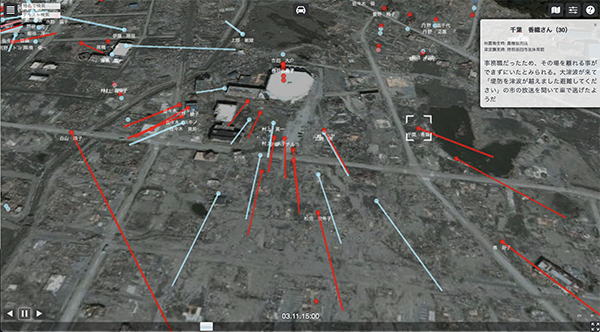
■Figure 3: Victims who gathered at public evacuation centers
Toward the Real Time Digital Archiving of Disasters
Fifteen years have passed since the release of the Tuvalu Visualization Project. Technology is evolving at an unprecedented rate. Regular people can now access 3D data, satellite images, and aerial photos of a disaster situation. We have also assisted in disaster responses[3] by promptly releasing 3D data, satellite images, and digital maps made of aerial photos in response to events such as Russia's invasion of Ukraine, the Turkey-Syria earthquake, and the Noto Peninsula and Taiwan earthquakes in 2024.
It is now possible to respond in real-time to ongoing disasters using digital archiving methods, not just record past calamities. Given the number of disasters, we will continue conducting various trials to rapidly and effectively support disaster responses and produce further technological advancements.
It is now possible to respond in real-time to ongoing disasters using digital archiving methods, not just record past calamities. Given the number of disasters, we will continue conducting various trials to rapidly and effectively support disaster responses and produce further technological advancements.
[1] Digital Archive Tuvalu Visualization Project
https://tv.mapping.jp/
[2] Digital Archive We Shall Never Forget - Last Movements of Tsunami Disaster Victims
https://wasurenai.mapping.jp/
[3] https://labo.wtnv.jp/p/blog-page_29.html
https://tv.mapping.jp/
[2] Digital Archive We Shall Never Forget - Last Movements of Tsunami Disaster Victims
https://wasurenai.mapping.jp/
[3] https://labo.wtnv.jp/p/blog-page_29.html