Ocean Newsletter
No.571 May 20, 2024
-
Research on Blue Carbon Using Underwater Drones
-
Automatic Feeding by AI Drone Based on Fish Hunger Level ~An Initiative to Nurture Fisheries~
-
A New Age of Discovery Brought About by Waterborne Drones
Research on Blue Carbon Using Underwater Drones
KEYWORDS
Underwater Drones / Seagrass Beds / 3D Orthophotos
YAMAMOTO Ikuo (Vice President of Nagasaki University, Professor at the Organization for Marine Science and Technology)
Underwater drones have made visualizing the ocean possible, raising hopes for their role in monitoring seagrass beds, which are crucial for environmental conservation and absorbing carbon dioxide. Nagasaki University’s Yamamoto Laboratory is developing underwater drones and is acquiring 3D orthophotos and identifying underwater environmental parameters with a focus on eel grass beds. This initiative is expected not only to contribute to ocean conservation by helping visualize these areas but also to the calculation of blue carbon credits.
Underwater Drones and Their Functions
Underwater drones refer to unmanned submersibles that navigate underwater, with typical examples being cable-operated ROVs (Remotely Operated Vehicles) and cable-free AUVs (Autonomous Underwater Vehicles) that can navigate autonomously. Yamamoto Laboratory has been developing ROVs for many years.
In this article I will introduce REMONA (Figure 1, left), an ROV equipped with AI capabilities developed in recent years. REMONA weighs 18 kg, measures 40 cm in length, 45 cm in width, and 28 cm in height. It is equipped with eight thrusters, which provide agile movement with six degrees of freedom. It can operate for three hours at a depth of 50 meters and a speed of 1.5 m/sec. The stereo cameras installed on the front and bottom allow measurement of the distance to the object and its orientation to be calculated, enabling high-resolution monitoring of target objects. The ROV calculates the target object’s features using the camera footage and continuously tracks the target using its optical flow and propulsion control functions. Optical flow refers to vectors representing the movement of pixels between two adjacent inter-image frames in a video. Observations using the lower camera mainly allow for investigating seabed ecosystems, such as seagrass beds, and inspecting offshore wind power infrastructure, like seabed cables. The images captured by the camera are converted into a frame grid in real-time, and the AI detects feature points. The detected feature points are used to track the target using optical flow. By performing tracking and station keeping control using REMONA's thrusters, it is possible to stably capture the observation target within the camera frame even if there is a current, as shown in Figure 1, right. Underwater drones are generally deployed directly into the sea from land. However, they are also often deployed from ships due to cable constraints and other factors. The Yamamoto Laboratory has now developed a composite marine mobility system that allows for underwater monitoring in conjunction with ship robots (see below), which is being operated in real-world marine environments.
In this article I will introduce REMONA (Figure 1, left), an ROV equipped with AI capabilities developed in recent years. REMONA weighs 18 kg, measures 40 cm in length, 45 cm in width, and 28 cm in height. It is equipped with eight thrusters, which provide agile movement with six degrees of freedom. It can operate for three hours at a depth of 50 meters and a speed of 1.5 m/sec. The stereo cameras installed on the front and bottom allow measurement of the distance to the object and its orientation to be calculated, enabling high-resolution monitoring of target objects. The ROV calculates the target object’s features using the camera footage and continuously tracks the target using its optical flow and propulsion control functions. Optical flow refers to vectors representing the movement of pixels between two adjacent inter-image frames in a video. Observations using the lower camera mainly allow for investigating seabed ecosystems, such as seagrass beds, and inspecting offshore wind power infrastructure, like seabed cables. The images captured by the camera are converted into a frame grid in real-time, and the AI detects feature points. The detected feature points are used to track the target using optical flow. By performing tracking and station keeping control using REMONA's thrusters, it is possible to stably capture the observation target within the camera frame even if there is a current, as shown in Figure 1, right. Underwater drones are generally deployed directly into the sea from land. However, they are also often deployed from ships due to cable constraints and other factors. The Yamamoto Laboratory has now developed a composite marine mobility system that allows for underwater monitoring in conjunction with ship robots (see below), which is being operated in real-world marine environments.
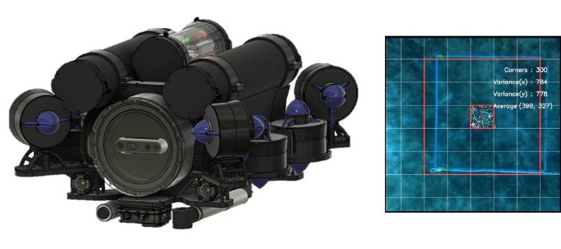
■ Figure 1 ROV/REMONA and captured image of an observation target
Blue Carbon Creation Using Seagrass Beds
The increase in global warming-causing greenhouse gases like carbon dioxide is an urgent issue. Although it is hoped that both forests and the oceans will absorb carbon dioxide, recently, there has been increased focus on the oceans for this purpose. Carbon accumulated in the biomass and seabed soil of coastal marine ecosystems is generally called blue carbon. Areas where carbon is sequestered can include seagrass beds, tidal flats, salt marshes, and mangrove forests. In Japan, it is hoped that rocky shore denudation can be mitigated and blue carbon created by maintaining and increasing seagrass beds. Because seaweed can absorb carbon dioxide in the water, blue carbon credit transactions, where credits are sold between businesses that want to reduce their carbon dioxide emissions and make efficient use of it, are attracting attention. This system enables credit purchasers to enhance their corporate value through their support for reducing greenhouse gases and environmental conservation. Applicants for these credits must evaluate and cultivate seagrass beds. As an evaluation method, it is first necessary to survey the types and amounts of seagrass beds, and underwater drones are effective for these tasks.
Capturing and analyzing images of seagrass beds with underwater drones enables the state of these beds to be quantitatively assessed. The acquired data helps in calculating blue carbon credits. In addition, advancements in marine renewable energy, such as offshore wind power, are also connected to blue carbon creation. Monitoring and inspections of underwater structures and seabed cables using underwater drones are important at all phases of these projects: before construction, during construction, and after completion. With REMONA, the distance to front structures can be measured using the front stereo cameras. If the onboard computer is trained to use possible damage to the structure being inspected as training data, damaged images can be automatically extracted using the equipped camera, and captured images can continue to be captured using the thruster controls even if there is a current. These are just some ways underwater drones can contribute to status observations and assessments in various strategies for creating blue carbon.
Capturing and analyzing images of seagrass beds with underwater drones enables the state of these beds to be quantitatively assessed. The acquired data helps in calculating blue carbon credits. In addition, advancements in marine renewable energy, such as offshore wind power, are also connected to blue carbon creation. Monitoring and inspections of underwater structures and seabed cables using underwater drones are important at all phases of these projects: before construction, during construction, and after completion. With REMONA, the distance to front structures can be measured using the front stereo cameras. If the onboard computer is trained to use possible damage to the structure being inspected as training data, damaged images can be automatically extracted using the equipped camera, and captured images can continue to be captured using the thruster controls even if there is a current. These are just some ways underwater drones can contribute to status observations and assessments in various strategies for creating blue carbon.
Experiment Around Nagasaki Goto Islands
To collect data on seagrass beds, an observation experiment on eelgrass beds was conducted targeting an area off the coast of Arikawago, Shinkamigoto Town, Minamimatsuura District, Nagasaki Prefecture, using ROV/REMONA and ASV (Autonomous Surface Vehicle) connected to an ROV as a composite marine mobility system. As shown in Figure 2, left, the ASV obtains position information via global positioning system (GPS) and autonomously navigates the sea surface. REMONA is stored in the ASV, detached from the ASV into the sea in the observation area, and then returns to the ASV after the observation for storage. Even with a current, the area being imaged did not deviate from REMONA's lower camera's field of view, allowing for fixed-point observation and video acquisition.
The observed seagrass bed images were processed into 3D orthophotos1, as shown in Figure 2, right, enabling the seagrass bed's area and volume to be calculated. In this experiment, a carbon dioxide sensor was also installed on the ASV to measure the underwater carbon dioxide levels in the seagrass bed. Traditionally, seagrass bed measurements are performed by divers, but underwater drones can carry out observation missions even under dangerous sea and weather conditions, providing timed and fixed-point observation data. Furthermore, obtaining 3D digital data of seagrass beds will assist in creating digital twins2. As data is accumulated, this will surely become an effective and innovative method for supporting the creation of blue carbon credits.
In the future, it is hoped to further enhance the autonomous mobility of these drones through advancements in AI and control systems. In addition, it is hoped that a system can be established for fast and stable transmission of the large volumes of data collected by underwater drones by utilizing underwater optical communication. Moreover, since drone propellers agitate water during observations of seagrass beds, using an oscillating airfoil propulsion system capable of fish fin-like movements developing fish-type drones will be essential for collecting environmental data.
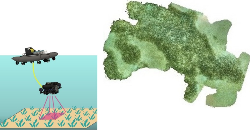
■ Figure 2: 3D Orthophoto of Seagrass Bed Captured by ROV/REMONA
1. 3D Orthophoto: Aerial photographs created as digital images by stitching together multiple photos, such as from satellites, correcting distortions, and adding coordinate values, among other adjustments.
2. Digital Twin: A technology that collects information from the real world via IoT and other means and uses this data to recreate real spaces in a cyber (virtual) space.
I would like to express my gratitude to the Carbon Recycling Fund Institute and everyone who supported this research.
2. Digital Twin: A technology that collects information from the real world via IoT and other means and uses this data to recreate real spaces in a cyber (virtual) space.
I would like to express my gratitude to the Carbon Recycling Fund Institute and everyone who supported this research.