Ocean Newsletter
No.570 May 5, 2024
-
Could the Coastal Uplift Caused by the Noto Peninsula Earthquake have been Predicted?
-
The Two Earthquakes that Hit the Noto Peninsula and Challenges for the Coming Earthquakes
-
The Forefront of Earthquake Prediction Research
Could the Coastal Uplift Caused by the Noto Peninsula Earthquake have been Predicted?
KEYWORDS
Noto Peninsula earthquake / marine terrace / earthquake forecasting
SHISHIKURA Masanobu (Group Leader of Collaboration Office, Geological Survey of Japan, National Institute of Advanced Industrial Science and Technology AIST)
The Noto Peninsula Earthquake, which occurred on New Year's Day 2024, caused coastal uplift of up to about 4 meters, rendering fishing ports non-functional. The marine terrace landform along the Peninsula indicates that uplift has repeatedly occurred with past earthquakes. Assessing the scale of uplift, based on marine terraces, and creating disaster measures are important in forecasting future earthquakes.
Large Uplift of Coastline due to the Earthquake
The earthquake that struck the Noto region on January 1, 2024, was large, with a maximum seismic intensity of 7 and a magnitude of 7.6 on the JMA scale respectively. Since the focal area spanned a range of about 150 km across both land and sea, it caused intense shaking typical of an epicentral earthquake, along with a tsunami, resulting in extensive and widespread damage. I would like to take a moment here to offer my prayers for those who lost their lives in this earthquake and express my sympathies to all those affected by the disaster.
In addition to the intense shaking and tsunami, a characteristic feature of this earthquake was the coastal uplift it caused. Immediately after the earthquake, I conducted an emergency field survey and confirmed an uplift of about 4 meters in the Kaiso district of Monzenmachi, Wajima City (Figure 1). Analysis of aerial photographs and satellite data by the Geospatial Information Authority of Japan confirmed the seabed had been exposed due to uplift along almost the entire northern coast of the Noto Peninsula. As a result, most of the fishing ports dried up and became non-functional, creating a significant barrier to realizing early recovery from the disaster.
In addition to the intense shaking and tsunami, a characteristic feature of this earthquake was the coastal uplift it caused. Immediately after the earthquake, I conducted an emergency field survey and confirmed an uplift of about 4 meters in the Kaiso district of Monzenmachi, Wajima City (Figure 1). Analysis of aerial photographs and satellite data by the Geospatial Information Authority of Japan confirmed the seabed had been exposed due to uplift along almost the entire northern coast of the Noto Peninsula. As a result, most of the fishing ports dried up and became non-functional, creating a significant barrier to realizing early recovery from the disaster.
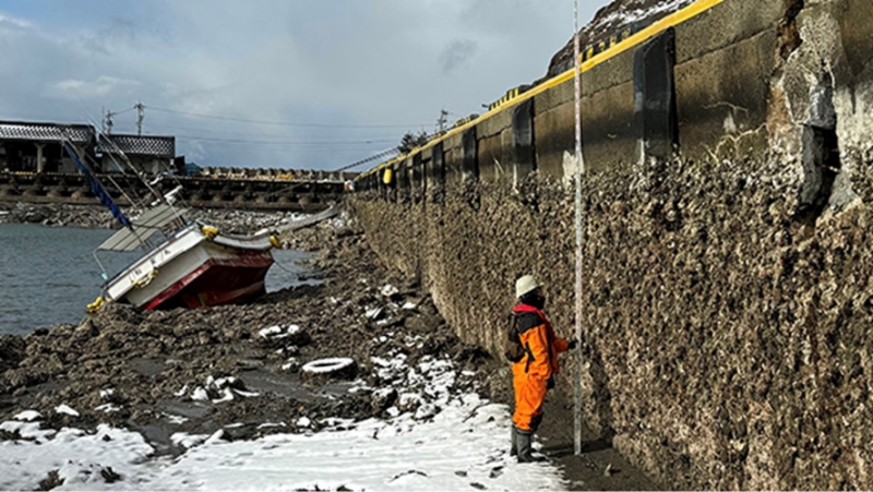
■ Figure 1: Kaiso fishing port in Monzenmachi, Wajima City, was uplifted by about 4 meters
The History of Coastal Uplift is Etched into the Landform
Coastal uplift often occurs due to earthquakes with epicenters close to shore. The first earthquake observations in Japan were made during the Meiji era, with the largest amount of coastal uplift ever recorded having been during the Great Kanto Earthquake of 1923. That earthquake caused an uplift of about 2 meters at the southern tip of the Boso Peninsula. However, the Noto Peninsula earthquake produced double that amount of uplift, making it the largest in recorded history. While such a significant uplift may seem unprecedented, large uplifts have occurred numerous times in the history of the Japanese archipelago. Evidence of this is found through marine terraces (also called coastal terraces). Marine terraces are step-like landforms consisting of flat surfaces and cliffs distributed along coastlines. They are formed when flat rock formations created through wave erosion near sea level are exposed by ground uplift.
A typical example of marine terraces can be seen in the southern part of the Boso Peninsula (upper photo in Figure 2). Before the aforementioned Great Kanto Earthquake in 1923, the Genroku Earthquake of 1703 created marine terraces with an uplift of up to about 6 meters. Several similar marine terraces can be found at even higher elevations. Examining these is useful for reconstructing the history of past uplifts and earthquakes. This information from the past also makes it possible to forecast future earthquakes. The Headquarters for Earthquake Research Promotion, a government agency, conducts long-term evaluations of Kanto earthquakes (such as the probability of future occurrences) using information from the Boso Peninsula’s marine terraces.
So, what about the Noto Peninsula? I had been conducting detailed surveys of the landform along the northern coast of the peninsula for 17 years prior to this earthquake. The results revealed at least three levels of marine terraces estimated to have formed within the past 6,000 years, stretching from the eastern to the western end of the peninsula (lower left photo in Figure 2). This finding indicates that significant coastal uplifts caused by large earthquakes have occurred along the entire coastline at least three times in the past few thousand years. I compiled these results into a paper which was published in 20201.
Around the time the paper was published, an earthquake swarm activity began in the Noto Peninsula, raising concerns about the potential for a major future earthquake. Then, on May 5, 2023, a magnitude 6.5 earthquake with a maximum seismic intensity of 6 upper on the JMA scale occurred. I immediately went to the site and confirmed there had been coastal uplift, but it was only about 20 centimeters at most, insufficient to form a marine terrace. Considering the possibility of a larger-scale earthquake causing significant uplift in the future, I began writing a new paper. Around the same time, the Headquarters for Earthquake Research Promotion also began discussing evaluating active faults in the southeastern sea area of the Japan Sea, including the Noto Peninsula. However, in the midst of all this activity, our concerns became a reality.
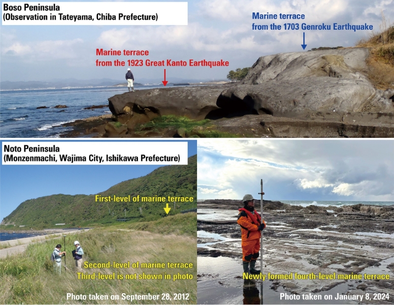
■ Figure 2: The marine terraces of the Boso Peninsula and Noto Peninsula. The lower left photo is partially modified from Shishikura et al. (2020; Active Fault Research No. 53).
Living on Land Created by Earthquakes
The scene that I witnessed just after the earthquake was literally the birth of a marine terrace. (bottom right photo in Figure 2). Although this event had been anticipated by previous surveys, the timing of this once-in-several-thousand-years occurrence was astonishing. Unfortunately, accurately predicting the exact occurrence time of these low-frequency events is extremely difficult. However, the fact that the scale and extent of the uplift were as expected reaffirms the usefulness of information about marine terraces for pre-emptive measures.
The Japanese archipelago has many areas which have been developed marine terraces. They can be found along the coast of the eastern margin of the Japan Sea, such as along Sado Island near the Noto Peninsula. However, there are no records of these being formed by recent earthquakes. This implies the potential for significant uplift during future earthquakes, which are expected to occur once every several hundred to several thousand years. On the Pacific side, in addition to the Boso Peninsula, marine terraces are also found at Omaezaki, Cape Shionomisaki, Cape Muroto, and Cape Ashizuri, all of which face the Nankai Trough. It is certain that they will be uplifted by large earthquakes in the near future. The lesson from the Noto Peninsula Earthquake is the need to move forward with earthquake countermeasures for ports, considering potential coastal uplift.
It is also important to acknowledge that coastal uplift has created new land. The Noto Peninsula itself is an area of land that earthquakes have gradually uplifted over more than a million years. All areas with marine terraces on the Japanese archipelago were once part of the sea, and we Japanese people live on land created by earthquakes.
1. Shishikura Masanobu, Echigo Tomoo, Namegaya Yuichi, "Activity of the off-shore active faults along the northern coast of the Noto Peninsula deduced from the height distribution of the lower marine terrace and emerged sessile assemblage," Active Fault Research (53), 2020.