Ocean Newsletter
No.284 June 5, 2012
-
The Indian Ocean Observing System (IndOOS)
-
Devising Innovative Ships According to New Physics-based Stability Criteria
-
Shima City as a New Sato-umi Town and the Kuki Clan
The Indian Ocean Observing System (IndOOS)
[Keywords] ocean observing, multi-national effort, socio-economic application
The Indian Ocean has in recent years become a focal point of geopolitical interest and strategic planning for major economic and military powers around the world. The economies of some nations in Asia, Europe and even the America’s are critically dependent on the flow of energy and free passage of oil along the shipping lanes of the Indian Ocean. With the rise of China and India as economic powers, a sense of competition and wariness has crept into the strategic planning of many nations with Indian Ocean interests. This article is about development of the Indian Ocean Observing System (IndOOS) and we believe it may have a role to play in helping to lessen the regional tensions. Prof Sandy Gordon (Australian National University) recently stated that, “What is needed [rather than competition] is a strategy designed to provide for joint action in the “commons?E to alleviate the sense of insecurity on the part of the major powers that their legitimate interests in the Indian Ocean might not be met.?E(see his excellent piece entitled Indian Ocean?Don’t Militarise the Great Connector at "http://www.futuredirections.org.au/publications/14-strategic-weekly-analysis/475-strategic-weekly-analysis-18-apr-2012.html" He goes on to make the point that nations with Indian Ocean interests should work together in the commons to address non-conventional security threats, and specifically mentions a host of environmental and natural disaster challenges among other threats. This is exactly what is happening in the development of IndOOS, and much more can be done as we begin to use the observations to address societal problems.
IndOOS) ※1 is a regional contribution to the Global Ocean Observing System. One of the exciting things about IndOOS is that it takes a well coordinated multi-national effort to make it happen. It was planned by the CLIVAR/GOOS Indian Ocean Panel※2 (a scientific body of experts with representatives from all the major powers with Indian Ocean interests) and is being implemented by the IndOOS Resource Forum※3 (high level administrators from national organisations around the world). IndOOS addresses the need to establish a system for comprehensive, long-term, high-quality, real-time measurements in the Indian Ocean suitable for climate research and forecasting, which provide scientific basis for socio-economic applications such as agricultural, fishery, and water resources managements (Figure 1). It also provides data on ecosystems and living resources in the Indian Ocean and how they depend on the physical environment. IndOOS uses a variety of instruments (Figure 2) that can be maintained at sea for long periods of time, and that can be operated in a cost effective way. Never-the-less it is a very expensive undertaking, placing a heavy demand on the members※3 of the IndOOS Resource Forum.
The XBT/XCTD lines may be of particular interest to readers of this newsletter because Japan was one of the first to contribute. At this moment, Japanese contributions to the XBT/XCTD lines in the Indian Ocean have been stopped due to lack of funding and man-power. The main contributors now are Australia, India, South Africa, UK and USA. Continuing this activity is important because the line-sampling is now our oldest record of the subsurface thermal conditions. The lines in Figure 2 represent the tracks of merchant vessels. Deck officers drop probes from the bridge every four to six hours to measure temperature (by expendable bathythermograph XBT) or temperature and salinity (by expendable conductivity-temperature-depth XCTD). Typically, each line is covered 12 to 18 times per year. The merchant ship program started in the Indian Ocean in 1983 and is the oldest component of IndOOS. Many Japanese ships have participated in the program over the years, along with the ships from many nations.
The rapid changes that can occur in the Indian Ocean dictate the need for a moored buoy array providing continuous time series data with high temporal resolution as an essential element of IndOOS. In this respect, the Research Moored Array for African?Asian?Australian Monsoon Analysis and Prediction (RAMA※4) supports research, understanding and predicting the East African, Asian, and Australian monsoons. In addition, real-time RAMA data will contribute to improved weather and marine forecasts, such as those for tropical cyclones and storm surge. The RAMA data has many potential applications and will benefit many nations both within and outside the Indian Ocean region because of atmospheric teleconnections that influence climate all over the globe.
RAMA is the newest component of IndOOS. It is of interest to readers that Japan and India were the first to install moorings in 2000. Japan played the leading role by discovering the so called Indian Ocean Dipole, which refers to the profound inter-annual reversals in ocean-wide sea surface temperatures, currents and winds between the eastern and western equatorial Indian Ocean and the impact on global climate.
In addition, satellite measurements of ocean surface conditions and variables in the atmosphere are an important backbone of IndOOS, providing high resolution spatial information for climate research and various applications. Close cooperation between the ocean observing system and satellite observations must be strengthened to further advance our understanding on climate variations in the global domain. Drifting buoys at the sea surface and at depth in the ocean are additional platforms for IndOOS. Autonomous, robotic instruments?so called Argo floats?measure temperature and salinity of the water column every ten days to a depth of 2000 m. There are more than 3000 Argo floats in the global ocean at present, of which about 760 floats are floating around within the Indian Ocean sector. The floats observe nearly all of the Indian Ocean shallower than 2000 m now and send the data in realtime via satellites. The data has many uses, including assessment of the role of the ocean in climate change and initialization of computer models to forecast seasonal climatic conditions. Australia and Japan are the major contributing countries for Argo floats deployment after India and United States.
The logistics of establishing and completing the RAMA moorings is difficult, requiring a high level of coordination across several organisations around the world. A final design of RAMA was completed in 2006 with joint publication of an implementation plan※1 by the Global Ocean Observing System and the World Climate Research Programme. Today organisations in Japan, India, USA, Indonesia, France, China and South Africa contribute to the array. In July 2011, 30 of the 46 sites had been occupied and new sites are being added each year. While IndOOS is growing, we are facing to some issues. One is lack of resources, in particular the ship-time for deploying and recovering the moored buoys and Argo floats. Coordination and collaboration under IRF※3 is a key to maximize our limited resources and to obtain continuous data from the Indian Ocean. Another issue is piracy in the northwestern Indian Ocean, which prevents any research cruises and observations in recent years. Strong leadership and international collaboration will be required for full implementation of IndOOS and for providing continuous data from the Indian Ocean that has large socio-economic and academic benefits.
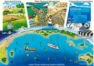
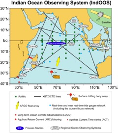 Figure 1: Schematic of ocean observing system in the Indian Ocean and its values for socio-economic applications. Data obtained by the observing system with various instruments are delivered to users directly or indirectly through weather/climate/ocean forecasting models.
Figure 2: The Indian Ocean Observing System. XBT/XCTD lines represent the tracks of merchant vessels. Deck officers drop probes from the bridge every four to six hours to measure temperature (by expendable bathythermograph XBT) or temperature and salinity (by expendable conductivity-temperature-depth XCTD). The merchant ship program started in the Indian Ocean in 1983 and is the oldest component of IndOOS. Green dots are fixed mooring sites in the RAMA* array where temperature, salinity, current and weather variables are measured. The first moorings were deployed in 2000 by agencies in Japan (JAMSTEC) and India (NIO). Argo floats are robotic instruments that measure temperature, salinity and biological properties to a depth of 2000m. Approximately 760 are deployed at this time. Surface drifting buoys measure temperature and current. Tide gauges measure sea level and the real-time reports monitor tsunamis. There are several Regional Observing Systems around the Indian Ocean that collect data in coastal regions. Occasionally research vessels are brought to the region for intensive Process Studies. *RAMA: Research Moored Array for African?Asian?Australian Monsoon Analysis and Prediction
Notes:
※1. CLIVAR?GOOS Indian Ocean Panel and Coauthors, 2006: Understanding the role of the Indian Ocean in the climate system?Implementation plan for sustained observations. World Climate Research Programme Informal Report No. 5/2006, International CLIVAR Project Office Publication Series 100, Global Ocean Observing System Report 152, 76 pp.
※2. CLIVAR/GOOS Indian Ocean Panel "http://www.clivar.org/organization/indian"
※3. IndOOS Resource Forum Ministry of Earth Sciences (India) chairs the Forum and participating agencies are IMOS (Australia), SOA (China), INCOIS (India), BPPT (Indonesia), JAMSTEC (Japan), INSU (France), SAWS (South Africa), NOAA (USA), ASCLME (International Organisation representing East Africa) and UNESCO/Intergovernmental Oceanographic Commission.
※4. McPhaden, M. J., G. Meyers, K. Ando, Y. Masumoto, V. S. N. Murty, M. Ravichandran, F. Syamsudin, J. Vialard, L. Yu, and W. Yu (2009), RAMA: The Research Moored Array for African- Asian-Australian Monsoon Analysis and Prediction, Bulletin of the American Meteorological Society April 2009 pages 460-480.