Shallow coastal areas have very delicate and complex natural ecosystems that are exemplified no more clearly than in the Ariake Sea, where Japanese Nori (seaweed) production has been damaged by outbreaks of red tide. Furthermore, a variety of phenomenon exist linking coastal areas closely to the geography and geology of landforms. Progression is being made in the research of coastal erosion, deep-sea areas, oil spills and other coastal issues, but we must learn more about the ocean to further advance environmental conservation and development.
Selected Papers No.2(p.4)
Ocean Newsletter
No.17 April 20, 2001
PDF
1.7MB
-
Learning About Coastal Regions from Geographic Features and Seabed Sediments
-
Realizing Japan's First Offshore Wind-Powered Generator
-
The Day the Whales Came
Learning About Coastal Regions from Geographic Features and Seabed Sediments
Shallow coastal areas have very delicate and complex natural ecosystems that are exemplified no more clearly than in the Ariake Sea, where Japanese Nori (seaweed) production has been damaged by outbreaks of red tide. Furthermore, a variety of phenomenon exist linking coastal areas closely to the geography and geology of landforms. Progression is being made in the research of coastal erosion, deep-sea areas, oil spills and other coastal issues, but we must learn more about the ocean to further advance environmental conservation and development.
The Spice of Variety in Coastal Seas
Somewhat different to deep-sea regions, there are some people who believe that almost everything is known about the coastal areas that adjoin our land. However, the actual feelings of someone who has been involved in ocean research for far more than ten years, is that there are still many unknown and non-clarified pieces in the coastal region puzzle. Take for example the very well publicized damage to the Nori (Japanese seaweed) industry in the Ariake Sea. The outbreak of such a crippling red tide portrays just how complicated, yet subtle, the ocean's natural functions can be.
Hokkaido has a shoreline of 2950km in length, which accounts for about 9% of the total length of Japan's coastline, and in comparison to the entirety of Japan its total area of 73,000m3 is strikingly similar in proportion, with its coastal regions being no deeper than 200 meters. In the surrounding area there is the Japan Sea through which the warm Tsushima Current moves north, the Okhotsk Sea where sea ice drifts south during winter and the Pacific Ocean down through which the nutrient filled Oyashio Current flows. In other words, three seas with totally different characteristics surround Hokkaido. In this relation and subject to the composition of rock on the seabed, the different sea currents and other varying factors, a large variety of terrain, sand, soil and other seabed sediment extend across the coastal zone of Hokkaido.
In the coastal seas that were traditionally used for mainly fishing purposes, recently there has been a continual increase in a number of different facilities, through the expansion of ports, the construction of bridges, landfill projects and other activities. At the same time, the extension of breakwaters into offshore areas has changed the flow of currents offshore, the amount of sand carried into such regions and the wave actions in the area, resulting in parts of beaches being eroded away and other complex phenomenon unique to the ocean also being witnessed.
What We Should Be Aiming For
The research institute where I work is an agency of the Hokkaido Prefectural Government, but is an organization that can't be found in other prefectural governments. Our main research areas are hot springs and underground water, volcano disasters, active faults, landslides, etc. In order to extend the knowledge built about land into coastal areas, in 1989 an "Ocean Affairs Department" was established and has been running through to this day.
During this time we have been able to confirm a variety of geographic and geological phenomenon. Targeting the ocean surrounding Hokkaido while the seas are calm from June through October and through the cooperation of fishing trawlers (around 5 tons in size) requested at the site of each survey, we have been measuring geographic changes in terrain, carrying out sonic profiling surveys on the thickness and expanse of sand and sludge and stowing survey apparatus such as mud sampling equipment on board the vessels to take actual samples of the sand and sludge in the Hokkaido surrounds. In addition, we have also managed to survey deep-sea volcanoes that erupted some 40,000 years ago, the remains of volcanic craters and small-scale volcanic gas emissions, active faults on the seabed that extend from land and the developments of submarine valleys.
Some tens or hundreds of thousand years ago, the rise and fall of the sea level occurred a number of times as a result of changes in climate and there were periods when much of the earth was covered in seawater and also times when many sea floors were part of land. We classify land and ocean on earth by whether it is covered by air or water, but the geological formation of stratum, rocks, etc. in coastal areas between land and sea extends continuously and no geological boundary exists. If you take this approach, land and sea are completely equivalent targets of research and survey. On land there are traces of the ocean and on the seafloor there exist traces of land, both of which provide us with many challenging research topics. I believe that research on the ocean should be approached by regarding the impacts and happenings on land as being unified with the ocean.
Making the Most of Outcomes for the Future
I would now like to present three remarks based on from the research of the Department of Marine Geoscience of our research institute.
The first is that of coastal erosion. In recent years, it has been extremely regrettable to see erosion thinning our beaches, manmade coastlines fixed in concrete spreading throughout our country and the expanse of our natural resources gradually declining, even in Hokkaido, which boasts of its plentiful natural features. By nature, beaches are formed through a delicate balance between the supply and loss of sand into coastal areas. If there is insufficient supply of sand or excess loss of it, then naturally beaches are going to retreat or disappear. There may well be some negative aspects to securing the supply of sediment, such as productive land being run down and oceans being contaminated by the washing out of river deposits. However, is it not more important that a suitable amount of sand is supplied to preserve our coastline? Whatever be the answer, observing these changes from a long-term perspective, and making efforts to clarify the complex mechanisms involved, will surely help in the prevention of erosion phenomena.
The second of my comments is on the utilization of deep-sea water reserves that are currently at the center of attention. In Hokkaido, the towns of Kumaishi, Iwanai and Rausu have put together action plans and are presently actively involved in the exploitation of such water resources. Amongst these activities, in the offshore region between Kumaishi and Iwanai there is a natural valley configuration that is very advantageous for pumping up deep-sea mineral water, because the seabed falls away very sharply just off the coastline and only a short pipeline is required. By making sonic profiling surveys, we were able to investigate the detailed formation and geographic features of the underwater valley, which was very important for deciding on the site for extraction and constructing the pipeline itself. We are also trying to maintain an accurate understanding of the change in nutrients, as a consequence of changes in season and depth, that is an important requirement for the sustained utilization of these resources into the future.
The last remark I would like to make is concerned with our research into the coastlines affected by oil spills. In January of 1997, an unforgettable happening was recorded when the Russian registered flagship "Nakhodka" was grounded off the coast of Fukui. Alongside those involved in the oil production activities in Sakhalin, the coastal region of Hokkaido didn't just regard this accident as the affairs of another nation, but in fact has requested more sufficient preparedness towards such potential disasters. In the United States and Canada that experienced the 1989 oil spill off the coast of Alaska, research into how the oil that was cast ashore by the accident has been permeated or remained in beach sand and gravel is being actively undertaken. The infiltration and retention of the oil differs between fine grains of sand and coarse gravel found in the coastal area, and clarifying the characteristics of such coastal sediment is a very beneficial reference for planning clean up operations on polluted beaches. Furthermore, by portraying the remaining amount of oil on coastline maps, based on the geographic features and sediment composition of the area, further attempts are being made to help in addressing future disasters.
Various interesting phenomenon also exist in the narrow coastal regions of Hokkaido, and for Japan as a whole, which has such limited land resources, we can rightfully expect furthered developments in the utilization of its coastal zone to continue into the future, through the use of advanced technology. However, in order to accomplish this and effectively utilize the coastal zone for aqua-cultural activities, the construction of seaside facilities and other similar activities, we need to know more about the oceans. Moreover, we must also improve our understanding of the hazardous nature of both ocean and sediment pollution and move to treat the oceans with the respect that they deserve. I believe that, through the continuation of scientific research and the wide dissemination of its outcomes, furthered understanding of the oceans needs to be gained from both the environmental preservation and development perspectives. Understanding the ocean is the first step towards treating it with respect
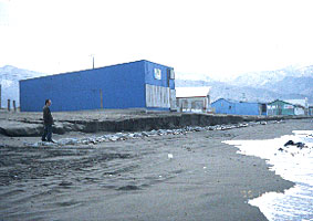 Picture 1: Sand beach cut up by wave actions (Otaru City, November, 1995).
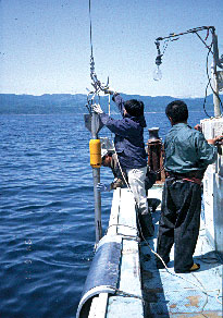 Picture 2: Sediment sampling by gravity corers.