 RSS
RSSTopography of Seabed Around Senkaku Islands
-
Feb 17, 2015
The Senkaku Islands are located on the edge of the vast East China Sea Continental Shelf. The Okinawa Trough, which is 1,000 kilometers long, around 100 kilometers wide, and from 1,000 to 2,200 meters deep, lies along the south and southeast of the same continental slope. The Nansei Islands Trench, with a maximum depth of more than 7,000 meters, runs parallel to the Okinawa Trough on the Pacific side of the Nansei Islands, an island arc that stretches from Tanegashima Island and Yakushima Island in southern Kyushu through Okinawajima Island to Yonagunijima Island. Heading out to the North Pacific, there are rifts and knolls in the Okinawa Trough, deep-sea terraces on the slope down to the Nansei Islands Trench, and the sheer cliffs of the Okinawa Escarpment. This demonstrates the great topographical diversity from the gentle downward slope from the Chinese mainland in the seabed around the Senkaku Islands, on the edge of the East China Continental Shelf, to the Nansei Islands Trench and the North Pacific.
There are a number of notable submarine valleys on the continental slope under the East China Sea around the Senkaku Islands. To the west of Uotsuri Island lie Nishi-Uotsuri Canyon and Nansei-Uotsuri Canyon, while to the east of Taisho Island there are the First and Second Taisho Canyons and the First and Second Hokuto-Taisho Canyons. There are also raised areas undersea, such as Uotsuri Knoll to the south of Uotsuri Island, Hokuto-Taisho Bank to the northeast of Taisho Island, and Minami-Taisho Knoll to the south of Taisho Island.
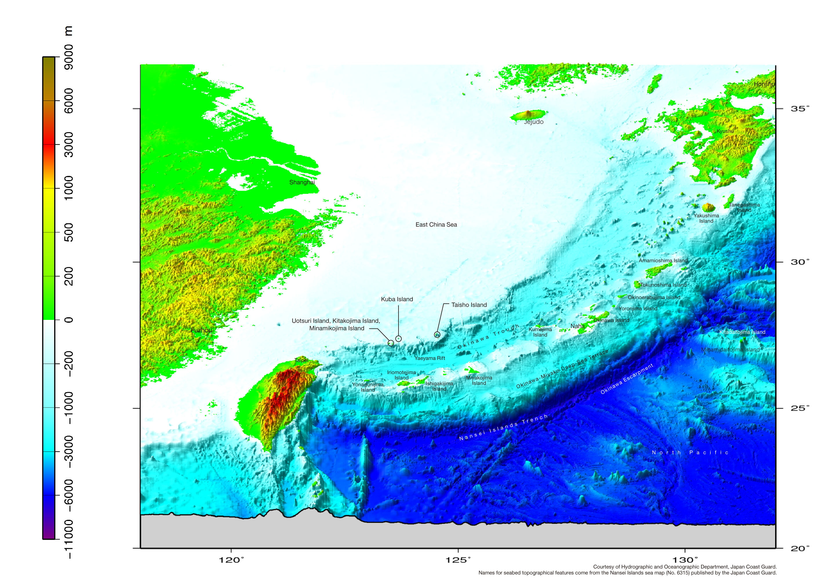
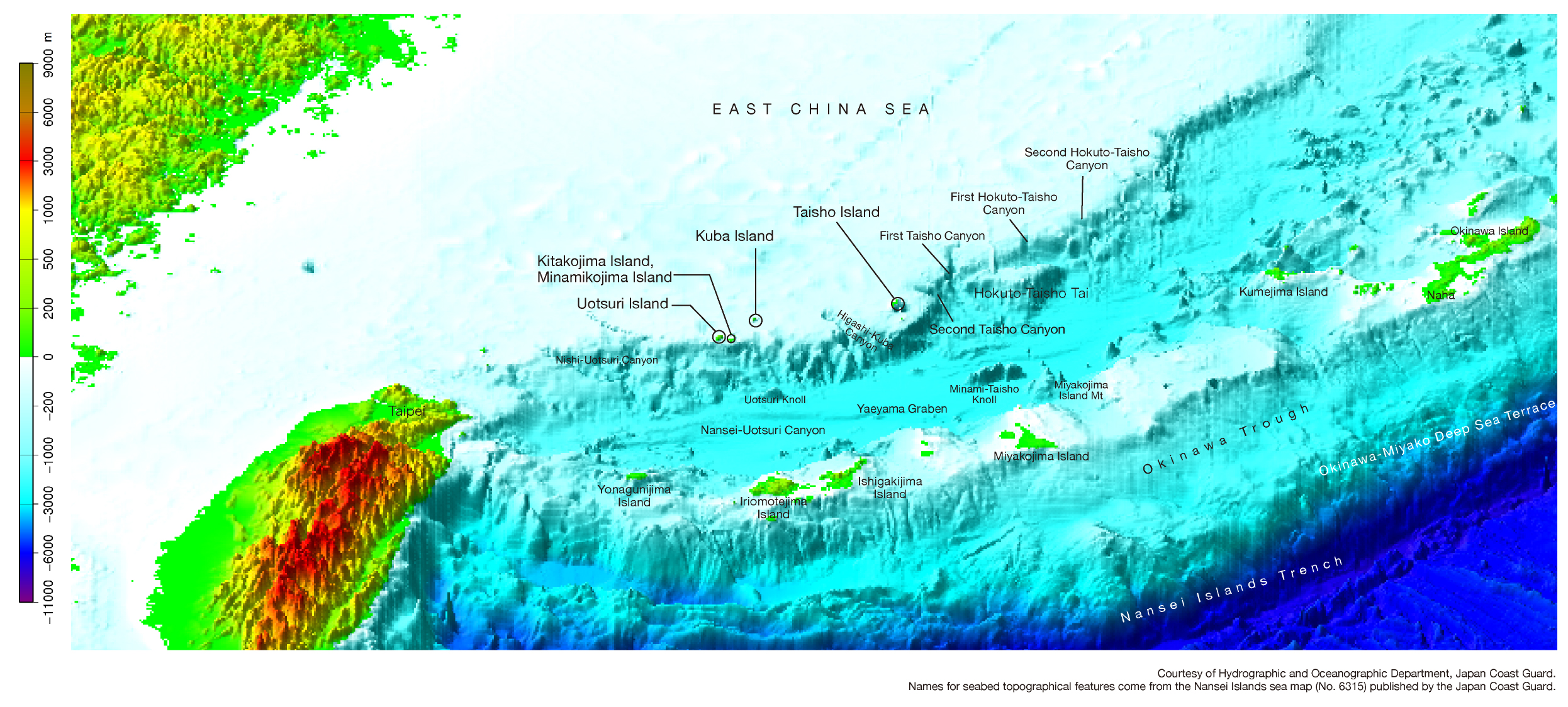

Courtesy of Hydrographic and Oceanographic Department, Japan Coast Guard.
Names for seabed topographical features come from the Nansei Islands sea map (No. 6315) published by the Japan Coast Guard.

→
Related Research

U.S. Recognition of Japanese Sovereignty Over the Senkaku Islands
Raul(Pete)Pedrozo (Sep 15, 2022)
Protest and Acquiescence in Territorial Acquisition: In relation to the Senkaku Islands
MIYOSHI Masahiro (May 01, 2018)
International Law and Japan's Territorial Disputes
Raul (Pete) Pedrozo (Feb 06, 2018)
The Senkaku Islands as Viewed through Chinese Law
SAKAMOTO Shigeki (Sep 12, 2016)
Related Readings
TAKAHASHI Noritsugu (Sep 15, 2022)
TAKAI Susumu (Sep 15, 2022)
CHIBA akira (Sep 27, 2021)
Notes on David Helliwell's "The Clashing Rocks"
ISHIWI Nozomu (Sep 12, 2016)
Info Library
Japan's Island Territories
Senkaku Islands Facts & Figures
Takeshima Facts & Figures
Northern Territories Facts & Figures