 RSS
RSSCreation of the New National Museum of Territory and Sovereignty - To build a place for thinking about Japan’s territories
Sep 15, 2022 PDF Download
Introduction – Purpose of this paper
On January 20, 2020, the National Museum of Territory and Sovereignty was relocated from Hibiya to Toranomon with expanded area. As introduced in Volume 9, No. 2[1] of the Journal of Islands Studies, the establishment of this newly relocated and expanded Museum owes its basic ideas to the recommendations by the Advisory Panel on Communications Concerning Territorial Integrity (July 29, 2019).[2]
The recommendations, titled “For Practical Initiatives to Strengthen Communication Based on Changes in the Domestic and Overseas Environment,” has gone far beyond just assembling general rules, suggesting many concrete plans presumed to be put into practice. All of the members of this Advisory Panel had either participated continuously in the Panel since its creation back in 2013, shortly after the Office of Policy Planning and Coordination on Territory and Sovereignty was established under the Cabinet Secretariat, or had actually been involved in activities in the area of territory and sovereignty. They joined not merely as leading scholars in academic fields, but gathered under the framework aligned for considering ways and means that meet specific demands, and are practically feasible. They visualized valuable ideas and thoughts in the form of the recommendation.
Hence, the new Museum was established by bringing together the knowledge of experts in the nation, and based on their discussion on the approach to developing a facility that is suitable for communicating Japan’s views on territory and sovereignty to people in and out of the nation. Fortunately, I happened to have an opportunity to be fully involved in the preparatory work to launch the new Museum from the planning stage as a staff member of the Cabinet Secretariat’s Office of Policy Planning and Coordination on Territory and Sovereignty. Through this paper, I would like to introduce what was borne in mind to reflect the blueprint depicted by the recommendations of the Advisory Panel on the new Museum’s actual content of the exhibits. Here I wish to note that all in this paper is my personal view, and the sole responsibility for the paper lies with the author.
This paper, in the first half, summarizes what was considered to embody the concept of the new Museum, so as to reflect the recommendations of the Advisory Panel on the actual plans. The second half goes to details, from section to section of the new Museum, on what was taken into consideration and what kind of features were intended to attach to its exhibits, bearing in mind the new concept as well as latest outputs in the field of material research, in particular, by contrasting the existent ways of explanation by the Ministry of Foreign Affairs (MOFA) and at the former Museum, and also exemplifying newly added contents and contrived methods of display. The greatest feature of the new Museum is, in fact, its linkage with the website by which to realize the more expanded and effective communication tool as a whole. However, this paper does not dare to delve into this, but rather, is focusing on the concept and exhibits of the new Museum established in January 2020.
1 Concept behind the new Museum
(1) Need for a physical museum
The most concerned question at the time of establishing the new Museum was “Why do we need a physical museum, now?” The multi-faceted concept behind the new Museum may be easy to be understood as answers to this key question.
In the modern Internet society, information can be sent far more effectively and efficiently via the web. The web can carry information to the order of million or tens of millions of Internet users in the world, whereas a physical museum can only deliver at a single location in Tokyo to its visitors as many as annual 100,000 at best.
If that is the case, on contrary, is the web communication enough? With regard to the government’s web-based communications on territory and sovereignty, the Ministry of Foreign Affairs (MOFA) site “Japanese Territory” [3] provides a largest volume of information on the government’s views, while the site of the Cabinet Secretariat’s Office of Policy Planning and Coordination on Territory and Sovereignty addresses the general public demand with more introductory contents.[4] The contents of the both sites are translated into foreign languages for communication overseas.
However, these websites alone are not considered enough for communicating the information on territory and sovereignty to audiences both in and out of Japan. Why is that so? The contents of these sites are well prepared. It may be not correct to make their quality an issue, if there is any room for improvement. One of the issues taken most seriously should be no link between these sites, missing the internet-unique synergy to attract viewer’s interest. This issue, rather lying inside the web, will be discussed later (see 3(1)). In this section, I will turn our focus beyond the limit of the web, that is, to the aspect that information is carried only to those who help themselves click and access the site, alienating the majority who do not click.
Is there any way to bring more of those who do not bother to click to click? The establishment of a physical museum can be a means to induce the attitude change (or more accurately, deeper understanding of the grounds for Japan’s territorial claims) for them to click.
(2) Functions that a physical museum should perform
What kind of functions should the physical museum play as a physical facility? The recommendations by the Advisory Panel set out various viewpoints concerning these functions. Here, I will explain the features of the new Museum by aligning them in the following order, which I believe best contributes most to readers’ understanding.
a. Function of symbolic indication that a permanent exhibition facility entails—concept that is slightly serious and mature
The establishment of the National Museum of Territory and Sovereignty as a permanent facility has a significance of placing a symbol to indicate the government’s intention to protect Japan’s territory, including the Northern Territories, Takeshima, and the Senkaku Islands, which functions in a way to demonstrate its posture of holding fast such determination. Certainly did the former Museum in Hibiya have a similar function since its opening. Nevertheless, located underground without any sign on the street level among other causes, it would be fair to say that the new Museum, now on the first floor in good location, is attached with this indicating function significantly more enhanced than before.
Symbol, though may sound somewhat unreal or imaginary, in fact has the effect of “announcing” the posture of the Japanese government to the public in and out of the nation, which is by no means virtual and exerts clear impacts that cannot be materialized by the web. Similar to the monuments, for reference, it should be noted that the National Museum of Territory and Sovereignty, when viewed in this way as a permanent facility with this symbolic function, sends messages as a whole, including, let alone the respective contents of the exhibits, the structure, the design, and even the impression given by the entire body.
i. Production of the key visual – A simple and modern design, and slightly mature
In planning the new Museum, a key visual was produced in light of the overall concept, based on which its overall design was to be drawn. The key visual, which later turned the Museum’s logo mark, was designed in consideration of the spontaneous expressiveness of its contents at a glance [visual recognition], and also wide acceptability and attractiveness to anybody who visits, not giving an impression of pushing propaganda, notwithstanding run by the government, but standing as a place to show evidential materials and provide explanations understandable to anybody, regardless of the countries they are from [objectivity and universality], thus intended to have a slight sense of solemnity so as to be ‘a place to learn and think,’ where kids must behave a little and study and ponder once you step in. As result, the key visual carries a design simple and modern, and slightly mature.
ii. Use of mascot characters to represent the Northern Territories, Takeshima, and the Senkaku Islands – Approachability for students and pupils
As the new Museum is also intended to be used for education, the perspective of approachability for children was also taken into consideration, while it is made rather a place of learning than a playground, where they are supposed to make efforts. In the meantime, in order not to alienate young students and pupils, the exhibits are accompanied by mascot characters that represent the Northern Territories, Takeshima, and the Senkaku Islands respectively.
With regard to the Northern Territories and Takeshima, as the mascot characters of Erika-chan (tufted puffin) and Lyanko-chan (Japanese sea lion) were used by the Northern Territories Issue Association and the Takeshima Archive of the Shimane Prefectural Government respectively, permissions were taken from those organizations to use their characters at the new Museum. Since there was no such a character for the Senkaku Islands, the Office of Policy Planning and Coordination on Territory and Sovereignty, the Okinawa Prefectural Government and Ishigaki City collaborated to create a character named “Alba-chan (albatross).”
In fact, at the old Museum, some mascot characters for tourism promotion of Shimane Prefecture and Ishigaki City had been used; however, for those characters are modeled after cats and eagles respectively, both not directly related to Takeshima and the Senkaku Islands, and even used to attract foreign tourists, including Korean and Chinese, they are kept from appearing at the new Museum.
b. Function of intuitive display by making the most of wider space – partitioned suitably for a place to learn and think
The next greatest feature of the physical exhibition facility is, naturally, the use of the physical space to enable intuitive explanations by display boards, exhibition equipment, replicas, and other facilities, which cannot be realized through the screens of personal computers and mobile devices. The exhibition equipment in the new Museum, such as projection mapping, large screens, display monitors, dioramas, and showcases to display replicas, has already been introduced in Volume 9, No. 2 of the Journal of Islands Studies and will soon be obvious once you visit in person; hence this paper will skip the details of them.
I would rather make a special note in this paper on how the space in the new Museum is partitioned.
Partly repeating the above, the new Museum, while avoiding plainly arraying all the elements of Japan’s territorial claims, aims at convincing visitors by annotating the claims one by one with objective corroborations, laid out in the long historical timeline spanning from the prewar to the postwar periods, so that they can comprehend the extensive explanations in each section, putting in the broader holistic perspective.
i. Large graphic board for exhibition
In order to create a place to think and learn, the floor in the new Museum is partitioned into small parts, not let open, to provide ample graphic surface to exhibit on the Northern Territories, Takeshima, and the Senkaku Islands respectively. In each section, wide, four or five meter-long jointless display boards stand on the left and right sides, and on the board a line is drawn horizontally as chronological axis to image the seamless and continuous flow of time.
This arrangement makes possible a framework of display broad enough for holistic explanation without any discontinuation in the timeline, averting selective picks of convenient events. Whereas the former Museum took a displaying method of arraying poster-sized panels, the new Museum enjoys largely augmented liberty of expression, enabling graphics to be drawn on the entire surface of the display boards.
In each of the sections of the Northern Territories, Takeshima, and the Senkaku Islands, the room is parted into the prewar part on the left from the entrance and postwar part on the right (see 2(1) below for the reason of dividing at World War II). The upper part of the board on each side sets out the key points of the grounds for Japan’s territorial claims, while the lower part lays out maps, images, charts, and other materials to substantiate the claims and explain backgrounds, so that visitors can understand each item without losing the broader chronological perspective. On the other side of the room facing the entrance, maps and dioramas of the islands on topic are laid out to provide geographic reference only by turning your face while reading the explanations on the prewar and postwar events.
Furthermore, the bottom parts on the prewar sides of the Takeshima and Senkakus sections show the assertions by the Republic of Korea (ROK) and People’s Republic of China (PRC) along with commentaries against them. This is intended to make clear conflicting points of the territorial claims, and thereby contribute to deepening understanding on the grounds for Japan’s territorial claims from diverse perspectives.
ii. Creation of common sections (Introduction/Conclusion)
Another feature of the partition in the new Museum is the creation of the common sections set at the beginning and end of the viewing route, before and after the individual sections.
Right after entering the Museum, visitors are first greeted by the purpose of the Museum, followed by an explanation on the San Francisco Peace Treaty, fundamental to all the sections of the Northern Territories, Takeshima, and the Senkaku Islands (see 2(1) below for details). Firstly, with regard to the purpose of the Museum, explanation is given on why it was chosen to have a trouble to establish this museum to explain on Japan’s territory. Sequently, before proceeding to individual sections, the focus is moved on to the conclusion of the San Francisco Peace Treaty, presumably the most important event in history in view of defining Japan’s territory today.
Next, in each section of the Northern Territories, Takeshima, and the Senkaku Islands, a board stands behind the entrance of the section, providing a brief introduction on the causes and background of the need to focus on each of the islands in the Museum, before going into the historical details.
After each section, explanations are given on the government’s response to the Northern Territories, Takeshima, and the Senkaku Islands respectively, along with the situations in which each of the islands has been surrounded, followed by the reactions by the government in response to those respective situations (see 2(5)a. below for details). As with Takeshima, there exists a territorial dispute with the ROK, while there is no dispute over the Senkaku Islands since PRC’s claim is simply unfounded. For the Northern Territories, it is also clearly stated that there is a dispute over the territory and negotiations have been taken place with Russia in pursuit of solution.
To the end, the exhibition continues to the government’s organizational structure to tackle the issue and its relevant measures, which proceeds to the territorial cases brought to the international tribunal for solution, as well as explanations on how to interpret materials used as evidence for the territorial claims. These are to provide reference for further in-depth consideration after the visit to the Museum (see 2(5)b. for details).
In this way, the partitioning of the new Museum, which makes the route beginning and ending with the common sections, between which the individual sections of the Northern Territories, Takeshima, and the Senkaku Islands are inserted, aims to enable visitors to understand the contents of the exhibits in each section in the broader context of territory and sovereignty, and to digest the grounds for Japan’s territorial claims on their own and give further thought, when encountering the assertions by other countries.
I wish to note that the exhibition with this complex partition harnessing the enlarged display surface was constructed in a very short period until the opening of the new Museum, thanks to the dedicated efforts of all the contractors of the content planning and production, design, display creation among others, in spite of the busy time over the year-end and new year holidays.
c. Function as a hub to gather collaboration of all the stakeholders – Aiming to become a nation-wide hub for relevant organizations and parties among the local governments and in territorial research, territorial education and other areas
The Advisory Panel suggested high expectations for the new Museum to function not only as an exhibition facility, but also as a hub for academic and journalistic research activities on the territorial issues. This hub function is a derivative of the symbolic function referred in a. above. Although a virtual facility may somewhat perform this function, a physical facility, with its substantial activities at a tangible base, can clearly show its capability of such a function.
The hub function that the new Museum should fulfill would include these elements: (i) a hub for relevant local governments; (ii) a hub for research institutions and researchers engaging in territorial research; and, (iii) a hub for research institutions and researchers engaging in territorial education. The Museum also naturally works as a hub for multiple relevant governmental organizations involved in territory and sovereignty, which is nonetheless only a part of the planning and coordination functions that the Cabinet Secretariat’s Office of Policy Planning and Coordination on Territory and Sovereignty is originally responsible for, and thus this paper will not delve into this point of the inner governmental coordination.
i. Hub for relevant local governments
While the territory of a nation is naturally a matter for the central government, the local governments that oversee in their administrative jurisdiction such remote islands on the national boarder as the Northern Territories, Takeshima, and the Senkaku Islands (i.e., Hokkaido (Nemuro Subprefectural Bureau), Shimane Prefecture, Okinoshima Town, Okinawa Prefecture, and Ishigaki City) play an extremely important role. The measures taken by those local authorities, though countless, include, for example, support for the former residents in the Northern Territories and the preservation of the materials that record their lives on the island at the time they lived there; the collection and preservation as well as research on the official documents of Shimane Prefecture, which has been administrating Takeshima and issuing fishery permits and other documents; the historical research projects of Okinawa Prefecture, which has a complex historical background, and the initiatives by Ishigaki City, which holds the Senkaku Islands as part of its administrative area. Furthermore, apart from these local governments, efforts related to territory and sovereignty have been made in various kinds of forms in extending places across Japan, such as Toyama Prefecture where many former residents of the Northern Territories live, Tottori Prefecture, which cannot be ignored in the material research on the activities on Takeshima in the Edo period, and Kyushu and other regions where many historical materials related to the Senkaku Islands are held.
For the new Museum, it is important to create a cycle of taking in the results of the efforts by local governments, disseminating them nationwide from the capital of Tokyo as national issues concerning territory and sovereignty, and then invigorating further activities in local areas, which in the end promotes collaboration and cooperation with local governments in the nation. From this perspective, in the process of producing the exhibits for the new Museum, putting aside referring to the PR material of the MOFA, it was intended to make those local initiatives visible, in collaboration and cooperation with the Hokkaido Prefectural Government through the Cabinet Secretariat's Northern Territories Affairs Administration with regard to the Northern Territories, with Shimane Prefectural Government through its Public Records Center and Takeshima Archive (General Affairs Division, Shimane Prefectural Government) with regard to Takeshima, and with Okinawa Prefectural Government and Ishigaki City including their municipal museums with regard to the Senkaku Islands. The use of the mascot characters, introduced in a. above, is also among such efforts.
ii. Hub for research institutions and researchers engaging in territorial research (Takeshima, the Senkaku Islands)
From the viewpoint of the hub function discussed in this part, Takeshima and the Senkaku Islands should be considered separately from the Northern Territories due to the significant gap between the former and the latter in their backgrounds and policy needs, in particular in that the initiatives for the latter have already been well organized at the national level.
With regard to the Northern Territories, numerous measures have been taken to realize the return of the territory in an organized manner through such organizations as the Northern Territories Affairs Administration within the central government, the Northern Territories Issue Association (Incorporated Administrative Agency) that is responsible for supporting the former residents and conducting research activities, as well as the Prefectural Councils for the Campaign for the Return of the Northern Territories. With the hub function already in existence, the new Museum is expected to participate in the existing network and take on a complementary role as a communication base in Tokyo.
With regard to Takeshima and the Senkaku Islands respectively, the Cabinet Secretariat’s Office of Policy Planning and Coordination on Territory and Sovereignty commissioned material research projects for six years from the fiscal year of 2014 to research and collect relevant materials with reference to past research products, such as those by Shimane Prefecture’s Takeshima Issue Research Group launched before the national research project, and articles in the Journal of Islands Studies. The new Museum, in its exhibits, extracts and organizes what is important to substantiate the territorial claim out of those results of the research projects, and integrates them with the existing line of the grounds for Japan’s territorial claims publicized by MOFA (see 2 below).
By exhibiting the research results considered to effectively corroborate the territorial claims along the government’s line of explanation, it is sought to enable the new Museum to show the implications of the research results in recent years as well as to suggest the study areas on which further research needs to be promoted, so as to fulfill the interface function of communicating public policy challenges to research institutes and researchers in the field of territorial research. The sizable exhibition space is required to materialize the exhibition of the contents full of the results of the academic research, which is a role that the former Museum could not play.
The study and research into the evidential material that substantiates Japan’s territorial claims entails a numbingly detailed and daunting amount of work, bringing together the knowledge and opinions of many experts. For instance, deciphering of the materials, including those in various ages from premodern to modern, involves the close reading of numerous documents written in old Japanese, old Chinese, English, and other languages. To interpret them accurately, it needs to study the governance system and other historical backgrounds in corresponding times, and analyze their significance as the corroboration of the territorial claims from the perspective of international law. Furthermore, those investigated materials need to be compared to the other countries’ assertions and materials as well as past relevant exchanges of views between Japan and those countries, and then it is assessed how valuable they are to be delivered to the public from time to time. With this complexity, the territorial research still remains immature in various fields, and necessitates further development along with training experts from now on. It is hoped that the new Museum will accelerate the consolidation of an environment to stimulate growth in the territorial research by functioning as the hub, while this hub function will be reinforced by delivering further related information on the contents in the new Museum for in-depth analysis through the “Research and Study Site” on the website of the Cabinet Secretariat’s Office of Policy Planning and Coordination on Territory and Sovereignty.
iii. Hub for research institutions and researchers engaging in territorial education
The new Museum is located close to the National Diet Building and other frequent destinations for school and field trips, as it is planned to be utilized for educational purposes. In particular, textbooks that will be authorized in accordance with the new curriculum guidelines with enhanced description related to territory will be used in elementary, junior high, and senior high schools successively in Fiscal 2020, 2021, and 2022. The new Museum should be more important as a facility for educational use.
It is unfortunate that little progress was made in the use of the new Museum as a site for school education this fiscal year [2020], due to the impact of the spread of the new coronavirus. However, efforts are being made to implement programs for children and other related initiatives by the end of July [2020]. In the future, the new Museum is expected to become a hub for school teachers and the developers of textbooks and educational materials, offering increased opportunities for information gathering and exchange.
In this chapter, this paper has attempted to explain the features of the new Museum as a permanent and physical exhibition facility by focusing on three functions of symbol, intuitive exhibition, and hub. As stated above, initiatives related to territory and sovereignty cannot be promoted by the government alone. Therefore, the new Museum is intended to provide a space to learn and think about the territory, widely involving local governments, researchers in a variety of disciplines such as history and international law, and those in the field of education, across the nation.
2 Contents of the new Museum – Commentary from section to section
Based on the concept in 1 above, this chapter will be explaining on the descriptions on display at the new Museum along with what is aimed and considered behind them. For the display at the new Museum in the sections on the Northern Territories, Takeshima, and the Senkaku Islands (corresponding to (2) to (4) below respectively), the same contents are available in English in the pamphlet and the website of the Cabinet Secretariat’s Office of Policy Planning and Coordination on Territory and Sovereignty,[5] Please refer to them for the actual description.
(1) Common section (Introduction)
a. Purpose of the exhibition
Right after entering the new Museum, visitors will first find on the display board the purpose of the exhibition,[6] or in short, why there is a need to establish a museum to explain matters related to Japan’s territory, as the first message to deliver (see 1 (2)b. ii. above). There are mainly two aims behind it. The first is the definition of the terms, territory and sovereignty, both fundamental to the entire exhibit; in particular, the latter may be less familiar than the former. Secondly, it also seeks to explain that the three main subjects of the exhibition, the Northern Territories, Takeshima, and the Senkaku Islands, are not in the same situation by any means.
i. Definition of territory and sovereignty
The theme of the new Museum is, obviously by its name, territory and sovereignty. Of these, territory is rather easy to perceive since it is tangible on a map, whereas the meaning of sovereignty may be more intangible and more difficult to understand. It may not be easy to define the latter in words. The old Museum shied away from defining them and moved directly into an explanation of Takeshima and the Senkaku Islands, on which visitors requested the term sovereignty to be explained in a way understandable to anybody.
The actual description of the purpose of the exhibition at the new Museum reads:
Sovereignty is the supreme right of administration that a state possesses within its territory
without subjection to any other authority, and means a right that demonstrates the
fundamental status of a state.
Candidly, the expression is not plain enough to get everybody to understand at a glance. This may sound an excuse, but it was necessary to borrow the expressions used in the government’s line of explanation on the occasions such as the Diet debates. More importantly, the sovereignty here, more precisely territorial sovereignty as used in the context of territory, contains several important elements as detailed below, forcing the complicated expression to be hired to describe such an idea succinctly within the given limited space. Certainly there might be room for improvement in the future.
The description on sovereignty in the purpose of the exhibition indicates that it contains three elements: a. independence (not subordinate to other authorities), b. supreme governing authority, c. fundamental status of a state.
The definition of the term of sovereignty is a major subject in both academic disciplines of constitutional law and international law, both deeply analyzed with the historical significance, as outlined below.
In the area of constitutional law, the following explanation seems general: “The concept of sovereignty, though containing various meanings, is used in the three meanings of (i) state authority itself (governing authority of a state), (ii) supreme independence as an attribute of state authority (the highest internally, and independent externally), and (iii) the highest decisive authority for state policies.”[7] This constitutional way of explanation on the concept of sovereignty corresponds particularly to the elements of a. independence, and b. supreme governing authority, in the aforementioned explanation on sovereignty in the purpose of the exhibition.
Meanwhile, in the area of international law, sovereignty is perceived as the authority that the state, a constituent entity of the international community, exerts over its own territory, and is regarded dichotomic. On the one aspect, the state territory is considered as the property of the state [object theory] and regards sovereignty as the power to “define the geographic area over which the state exercises its exclusive rights pertaining to land ownership and use. On the other aspect, the state territory is considered as “a space for exercising the ruling authority in order to ensure the legitimate interests of the state” [space/ authority theory], and regards sovereignty as “the power to exercise comprehensive state jurisdictive authority over all those who stay inside.” Territorial sovereignty is considered to have both characters.[8] Compared to the constitutional explanation, the character of “supreme independence” in the constitutional explanation, is explained from the perspective of the international law, emphasizing the “exclusive” nature exerted to the possessed property, which territory is deemed as. The “governing authority” in the constitutional explanation is explained as “state jurisdictive authority” that the state exercises over the space of its state territory (including territorial waters and air space).
This kind of analysis on territorial sovereignty is substantial and interesting, but would deviate from the purpose of this paper if delving too far. For here, it may be sufficient to note that the ownership of territory includes the two facets of possession and rule. It may be easier to understand this by tracing the origins of territorial sovereignty back to the time of the ancient Rome and the medieval Europe, and considering that it is a concept of dominium (land ownership) and imperium (territorial control) in combination[9]. Territorial ownership and possession are often confused. Certainly, the word “possession” is sometimes used in the meaning of the attribution of an island, even in official documents such as the consultation documents pertaining to the Peace Treaty with Japan. In the meantime, I have been asked in conversations with American and European scholars to make sure if the topic is Japan’s “sovereignty,” which is rather used to refer to territorial ownership by a state. Here, I wish to add one more supplementarily that the aspect of possession in the territorial sovereignty includes not only the rights of use and development, but also disposal (for example, the Treaty for the Exchange of Sakhalin for the Kurile Islands of 1875).
With regard to the description of “a right that demonstrates the fundamental status of a state” in the purpose of the exhibition (corresponding to c.), from the perspective of international law, the state is “the only international legal entity that is founded upon the territory (territorial organization).”[10] Territory is a qualification of the state, and the state is considered to be the only entity that can obtain territory. The international community holds a structure of maintaining social order, based on the states, constituent entities of the society, exercising their sovereignty over their own territories, although various rights and obligations are established for international public interests in the contemporary time. The expression of the “right that demonstrates the fundamental status of a state” does not simply refer to the rights that a state possesses, but implies the status of the state as a constituent entity of the international community with this unique structure.
In the purpose of the exhibition, the description on sovereignty, only first a few lines, holds important implications as the foundation for the overall contents of the exhibition at the new Museum. It is intended to help visitors anticipate the contents of the exhibition that follow and gain deeper meanings when reading for the second time after understanding the contents of the exhibition.
ii. Geographical subjects of the exhibition, and the territory that is inherent to Japan
Following the aforementioned sovereignty, the focus of the purpose of the exhibition moves on to the geographical subjects to be covered in the Museum. No wonder it does not cover all the parts of Japan’s territory--it would be touristic information.
First, it clarifies the Northern Territories and Takeshima as places where Japan is unable to exert all of its jurisdiction effectively, even though these are territories under the Japanese sovereignty.
Next, the Senkaku Islands is brought as a place where no territorial issues exist but the surrounding situation is becoming increasingly complex. In this part, it is clarified that the Senkaku Islands have different backgrounds from the Northern Territories and Takeshima.
On top of that, it explains that these islands constitute the inherent territory of Japan; that is, they have never been the territory of any other country. Then this part ends with the description of the object covered by the exhibits, that is, the explanation on the historical background of how they became a part of the Japanese territory.
b. The end of World War II, and Japan’s territory
Next to the purpose of the exhibition in the Museum are the three entrances of the sections of the Northern Territories, Takeshima, and the Senkaku Islands, and prior to entering these entrances, the explanation is displayed concerning the situation in which Japan’s territory had been placed since the end of the war until the enter into force of the San Francisco Peace Treaty with Japan.[11]
That is to say, prior to beginning the explanations on territorial claims in each section, common basic background on defining the limitation of the current territory of Japan is described, outlined as follows:
- 〇In August 1945, World War II came to an end with Japan’s acceptance of the Potsdam Declaration, and the country was placed under the occupation of the Allied Forces.
- 〇 The San Francisco Peach Treaty with Japan, signed by 49 states in September 1951, most of all those comprising of the international community at the time, confirmed that Japan gave up a part of its territory, but the Northern Territories and Takeshima were not included in the areas given up by this Treaty, but confirmed to be a part of Japan’s territory. In addition, the Nansei Islands, including the Senkaku Islands, were regarded as a part of Japan’s territory.
This explanation inform visitors at first that the Northern Territories, Takeshima, and the Senkaku Islands have all been recognized in the international community as part of the Japanese territory by virtue of the San Francisco Peace Treaty.
(2) Northern Territories section
This section did not exist in the former Museum, but was newly added to the new Museum. While
several exhibition facilities on the Northern Territories had been established in Hokkaido, no such
facility had been built in Tokyo. Hence, this new section had been established in response to
requests from various fields.
- The features in the production of this section are as follows.
- 〇The Northern Territories are inhabited islands, and a large number of Japanese people had been living there until the invasion by the Soviet Armed Forces. A large volume of records on the former residents’ lives in the islands are still existing.
- 〇Even today, Japan is engaged in diplomatic negotiations with Russia toward the conclusion of a peace treaty and places an emphasis on the fact that the negotiation is continuing.
- (At the opening of the new Museum, Japan received a demarche for caution from Russia.)
a. Entrance to the section
In this part, before expounding the historical background, the explanation outlined as following is posted to stress what has caused the issues still continuing today.
- 〇Firstly, at the end of World War II, the Soviet Armed Forces ignored the Neutrality Pact between Japan and the Soviet Union that was still in effect at the time and participated in the war against Japan, invading the Northern Territories.
- 〇At the time when the Soviet Armed Forces invaded Japan, many Japanese people were living in the Northern Territories, and forced to leave there.
- 〇Even now, Russia continues to occupy the Four Northern Islands without any legal basis. A peace treaty is yet to be concluded due to the Northern Territories issue, and Japan has engaged in the negotiation with the Soviet Union/ Russia until today.
b. Prewar
The explanation basically follows the line of explanation used in MOFA’s website and other sources. In the Edo period, Matsumae Domain had gradually established its rule over the Four Northern Islands. The national boundaries were defined with Russia in the Edo period, and with the conclusion of various treaties with Russia related to territory, the Northern Territories were consistently treated as part of Japan’s territory and inherent to Japan.
c. Audiovisual exhibition (large screen, projection mapping, etc.)
Peculiar to the Northern Territories is that a large number of residents were living there at the time of the Soviet invasion. This section was created in a way to help visitors understand this point intuitively. A slideshow of photographs depicting the lives of the former residents is projected on the large screen, and utensils actually used in their everyday lives are put on display.
In the section, a projection mapping display is also equipped to illustrate the scenes of the invasion by the Soviet Armed Forces with their movement animated on the map, intuitively showing the size and shape of the Northern Territories (for example, it may be little known that Etorofu and Kunashiri Islands are larger than the Okinawa main island, and the fifth and sixth most sizable islands in Japan).
d. Postwar
This part explains the fact that bilateral negotiations have been ongoing with the aim of concluding a peace treaty from the time of the Japan-Soviet Joint Declaration of 1956 until the recent Japan-Russia Summit Meeting, introducing a number of photographs and outcome documents.
In addition, it also points out that it is the basic common recognition of Japan and Russia that the two countries are in the abnormal situation of not having concluded a peace treaty even today, and also that they are implementing cooperative projects related to the Northern Territories.
(3) Takeshima section
a. Entrance to the section
Before expounding the historical background, at entrance of the Takeshima section, the explanations outlined as following is shown to draw attention to what has brought the current issues.
- 〇From 1953 to 1954 the ROK occupied Takeshima illegally and is still continuing the occupation today.
- 〇The actions of the ROK are not acceptable by Japan, nor the international community.
- 〇Japan’s territorial sovereignty over Takeshima was confirmed in the provision of the San Francisco Peace Treaty, nevertheless the ROK unilaterally established the Syngman Rhee Line in the form of incorporating Takeshima as part of its territory, maintained this line while ignoring the protests from the international community, and unilaterally occupied Takeshima illegally by physical forces.
- 〇 Japan has proposed to refer the issue to the International Court of Justice, and been attempting to solve the issue by peaceful means. In contrast, the ROK has continued ignoring Japan’s proposals and, even worse, moved to make the illegal occupation an accomplished fact.
b. Prewar
In explaining the grounds to Japan’s territorial claims in the prewar period, it is particularly important to present in a clear and understandable manner the fact that Japan’s territorial ownership of Takeshima began in the Edo period and has continued until the present day. Japan’s rule over the territory as a modern state began after the incorporation of it into Shimane Prefecture in 1905, which brought the significantly increase in the quantity and quality of the evidential materials. Due to this change, the methods of the explanation on the territorial claim become inevitably different before and after 1905, nonetheless, the nature of the territorial sovereignty does not change. Therefore, the exhibit in this part should impress the continuity of the territorial sovereignty.
In the prewar part, using newly collected materials, the display was created to clarify crucial points and reinforce with added materials for substantiating Japan’s territorial claims and disproving the ROK’s assertions. The following is a summary of the points taken with special attention for the production of the exhibit.
i. Contrast in the Edo period of the full use of Takeshima by Japanese with the involvement of the Shogunate government and Domains, against the doubtful geographical recognition of the ROK’s claims on Takeshima in the same period
For more intuitive illustration of the fact that Japanese people obtained permission from the shogunate government in the early Edo period to travel to Utsuryo Island and Takeshima, and institutionally and continuously used the islands, the display is arranged in a way to bring in a sight the time of the scene, the geographic images through maps, historical documents such as the permit to travel to Takeshima (Utsuryo Island), the crest of the Tokugawa family and other relevant materials. Among the documents on display are not only those pertaining to Utsuryo Island but Takeshima, which corroborate the recognition at the time on the value of Takeshima per se and the approval of the shogunate for its use. These materials are a part of the Oya Family Documents that were donated to Shimane Prefecture in recent years. Owing to the collaboration with the prefecture, the latest outcome of the material research can be put on display.
Contrasting with Japan’s situation in the early Edo period, the ROK’s assertions of its ownership of Takeshima in the 15th century are cited below the timeline with annotations on it. The grounds for the ROK’s claim lie in the antient Korean official documents of the time that records Takeshima under the name of “Usan,” however this “Usan” is depicted in the west of Utsuryo Island and cannot possibly be Takeshima, as explained in the annotation on display. The contents of the counterargument to the ROK’s assertions have been only extracted from MOFA’s pamphlet, but in the exhibit, the way of illustration is figured out to notice that even a simple comparison of the ROK’s assertion with Japan’s territorial claims in premodern times is enough to indicate the significant difference in the specificity of the claim as well as the depth of geographical recognition and the situation of the actual use of Takeshima (not Utsuryo Island).
Juxtaposing with the ambiguous geographical perception that Korea held concerning the islands in the Sea of Japan, the medium-sized display in this part introduces antient maps that show the Japanese geographical recognition in the early to mid-Edo period. Takeshima is depicted separately as Nishijima (Ojima) Island and Higashijima (Mejima) Island, and details such as the distance and direction from the Oki Islands are described accurately, which elucidates the substantial use of the islands by the Japanese at the time.
On the back of the basic exhibition area (central part of the Takeshima section), a large-size panel with illustrations is posted to give more details of the travels to Utsuryo Island and Takeshima by the Japanese in the early Edo period with three parts: the relationship with the Shogunate government and Tottori Domain (audience with the Shogun, presentation of dried abalone to the cabinet officials of the shogunate, etc.); the relationship with the Oya family and Murakawa family; and the relationship with Korea (facilitations provided by the So family of Tsushima Domain for the return of the Japanese in distress from Korea to Japan, etc). For this exhibit, too, many Oya-Family Documents, provided by the Shimane Prefectural Government, are on display.
ii. Clarification of the reasons for prohibiting travel to Utsuryo Island after the Genroku Takeshima Ikken (Takeshima Affair in the Years of Genroku), and the true portrait of An Yong-bok, regarded as a hero in the ROK
The exhibit in the new Museum clarifies and emphasizes the fact that in the Genroku Takeshima Ikken (Takeshima Affair in the Years of Genroku) (1693 – 1696), in which the shogunate government made a decision to prohibit the Japanese from traveling to Utsuryo Island, travel was prohibited only to Utsuryo Island, and that the reason for the decision was not because the shogunate government recognized Korea’s ownership of Utsuryo Island, as asserted by the ROK, but because the shogunate government wished to avoid unnecessary conflicts with Korea.
With regard to An Yong-bok, who is said to be the first person on the land of Japan to have claimed Korea’s ownership of Takeshima, the exhibition features in a box article the current situation that he is revered as a hero in the ROK today with a stone monument erected in his honor. The ROK’s assertion is also shown on the exhibit below the sign of timeline; however, in fact, the Korean government at the time treated him as a criminal and considered that the statements he made in Japan should be ignored, which is brought into focus on the exhibit.
The Genroku Takeshima Ikken is an issue that has generated much debate ever. Although the content of the exhibition is based on the existing line of reasoning and not novel at all, the way of the display of the materials is originally made to attract visitors’ interest by focusing on the personal character of An Yong-bok.
iii. Explanations on the confusion over geographical perceptions at the beginning of the Meiji era, such as the inclusion of fictitious islands on authentic maps and changes in the names of islands
This part explains that, at the start of the Meiji era, while there was growing geographical interest in the islands in the Sea of Japan alongside the expansion of European powers’ influence into East Asia, islands such as Utsuryo Island and Takeshima began to appear on maps, however, there were cases where the names of the islands were switched in the maps widely used at the time, or where fictitious islands were depicted on the maps. As the government at the beginning of the Meiji era used these maps for reference, they gave rise to confusion at the time with regard to the geographical recognition of the area around Takeshima. The confusion over this geographical recognition was gradually resolved after the government conducted on-site investigations in the early to mid-Meiji era.
With regard to this confusion over geographic names at the beginning of the Meiji era, while there is a concern that it would complicate the explanation, this point is included in the exhibition, because as far as the grounds for Japan’s territorial claims in the Edo period, it is not possible to gain an accurate understanding of the materials without knowing that the present-day Takeshima had been called “Matsushima” in the past, and also for studying the materials in the early Meiji era, it is indispensable to have knowledge of the confusion over the geographical recognition of Utsuryo Island and Takeshima at the time.
iv. Clear descriptions on the background of the incorporation of Takeshima into Shimane Prefecture (1905) was led by the private sector
With an increasing volume of evidential materials after the start of governance as a modern state, the explanations on the grounds for Japan’s territorial claims have also become increasingly detailed. However, this does not make any difference in the nature of the territorial sovereignty. Thus the exhibit in this part after the incorporation into Shimane Prefecture is titled “Continuous execution of the administrative right over Takeshima,” to give an impression of the continuity of Japan’s rule in words, as well as in the design with a sense of uniformity, such as a long seamless arrow of timeline.
With regard to the Cabinet decision to incorporate Takeshima into Shimane Prefecture in 1905, the explanation on the exhibit centers on the fact that this decision was made at the request from the private sector demanding the introduction of fishery regulation, facing the growing activities of hunting sea lions in the Takeshima area by the fishermen of the Oki Islands. One of the panels on the back of the basic exhibition area (central part of the section) provides supplementary information on the situation at the time of the sea lion hunting and the development after the incorporation into Shimane Prefecture. In this way, Takeshima was incorporated into Shimane Prefecture in response to the growing policy needs from the private sector, and Japan began exercising its administrative authority as a modern state. Through the explanation of these facts, it will become understandable that the ROK’s assertion of Japan having expanded its territory in line with its imperialistic policies in the last period of the Russo-Japanese War contradicts the fact.
Below the timeline on the exhibit, the annotation in the box points out that, with regard to the ROK’s assertion that Takeshima was incorporated into Uldo County as “Seokdo” in 1900, prior to the incorporation into Japan’s Shimane Prefecture, the identity of “Seokdo” as Takeshima is doubtful, and moreover the Korean government had never exercised its effective control over the islands, which does not establish its territorial sovereignty at the time.
The panel in the central part of the Takeshima section on the back of the basic exhibition board complements these doubts over the ROK’s assertions, and furthermore, displays documents and materials that show that the Korean government at the time even did not have any geographical recognition of Takeshima in the first place.
v. Systematic itemization of the documents that record the exercising of administrative authority over Takeshima after the incorporation into Shimane Prefecture
The final prewar part displays major records of the administration over Takeshima as a modern state after the incorporation into Shimane Prefecture by classifying them into items. It explains that Takeshima was placed under the jurisdiction of Shimane Prefecture, and was substantially administered including registration, taxation, and permission and licensing. Many of the materials on display are collected in cooperation with Shimane Prefecture. While the existence of these materials had been known from before, they are displayed in such a systematic and organized manner for the first time.
c. Postwar
In the basic exhibition of the postwar part, a large display wall is used to explain with a number of maps and charts indicating that (i) in the drafting process of the San Francisco Peace Treaty, which legally defined Japan’s territory after World War II, Takeshima was recognized as part of Japan’s territory, as indicated not only in the communication between the United State and the ROK, so-called “Rusk Letter,” but also in the treaty negotiations among the US, the United Kingdom and other countries; (ii) the ROK, facing the denial of its request for the amendment of the draft treaty concerning Takeshima’s attribution to the ROK, resorted to a unilateral action of the establishment of the Syngman Rhee Line among others, which gave rise to protests from the international community.
i. The drafting process of the San Francisco Peace Treaty – Clarifying the chronology of the US-UK negotiations that confirmed Japan’s territorial sovereignty over Takeshima
In the current line of the explanation, the “Rusk Letter” from the US to the ROK has been cited as a document that indicates that the San Francisco Peace Treaty confirmed Takeshima as part of Japan’s territory, by which the message was delivered to the ROK that Takeshima was under the jurisdiction of Shimane Prefecture in 1905 and had never been claimed by Korea. In addition to that, the exhibition at the new Museum illustrates that in the early stages of the preparation for the joint draft by the US and the UK, while the draft proposal that excluded Takeshima from Japan’s territory was discarded, the text that confirmed the inclusion of Takeshima in Japan’s territory was adopted, and this draft became the final text of the treaty without substantial changes. Therefore, the content of the Rusk Letter was not only the views of the US, but also based on the drafting process of the treaty, which was signed as a result of the negotiations.
For lucid explanation of the drafting process of the treaty, the exhibit was created along the line mainly based on the following points with maps and charts.
- 〇Firstly, as the result of Japan’s acceptance of the Potsdam Declaration at the end of the war, the attribution of minor islands other than Honshu, Hokkaido, Kyushu, and Shikoku was provided to be determined by the Allies. With regard to Takeshima, which falls under the “minor islands” set out in the Potsdam Declaration, the attribution of Takeshima was to be determined by the peace treaty, which clarifies the significant role of the peace treaty on this issue.
- 〇In the consultations between the US and the UK, two ideas were initially proposed. One excludes Takeshima from the realm of Japan’s territory, and the other would only stipulate that Japan give up Korea.
- 〇In the process of consultations between the US and the UK, they discarded the proposal that would exclude Takeshima from the realm of Japan’s territory, and concurred on preparing the draft text based on the proposal to only stipulate that Japan would give up Korea, while the UK pointed out that the attribution of the islands between Japan and Korea should be clarified. Then they decided that the treaty stipulate that Japan would renounce its claim to “Korea, including the islands of Quelpart, Port Hamilton and Dagelet,” without mentioning the territories that would remain in Japan’s territory, including Takeshima.
- 〇 The US delivered in its replying letter to the Ambassador of Korea (Rusk Letter) on its recognition that Takeshima was under the jurisdiction of Shimane Prefecture in 1905, and had never been claimed by Korea.
- 〇The joint draft by the US and the UK was distributed for consultation to the relevant states without substantial changes on the provisions concerning territory in relation to Korea, and the treaty was so signed at the San Francisco Peace Conference.
ii. Clear descriptions of the course of the events behind the unilateral establishment of the Syngman Rhee Line by the ROK as a result of the rejection of its request to amend the draft treaty and its illegal occupation of the island thereafter, along with protests by the US and the UK against the ROK and other negative views
The existing line of explanation has been that the request by the ROK to insert a provision in the treaty to include Takeshima into Korea’s territory was rejected as written in the Rusk Letter from the US, which led the ROK to unilaterally establish the Syngman Rhee Line and occupy Takeshima illegally.
In an effort to make the course of the events more understandable, the explanation in the exhibition at the new Museum adds information that the ROK’s request included the maintenance of the MacArthur line, in addition to the inclusion of Takeshima in Korea; both elements of the request were rejected by the US; and then the ROK issued a proclamation of maritime sovereignty unilaterally and then established the Syngman Rhee Line. Furthermore, complementing the previous explanation that Japan protested against the establishment of the Syngman Rhee Line by the ROK, this exhibition adds that, aside Japan, the US, the UK and other countries also lodged their protests, and that the ROK’s actions faced international criticism.
To make it easier to understand the contrast between this series of the assertions and actions by the ROK, and the views of the US and other countries, the exhibit was created along the line mainly based on the following points with maps and charts.
- 〇 With regard to the joint draft by the US and the UK, the ROK had requested for the insertion of a provision stating that Takeshima is included as part of Korea’s territory, as well as a provision for the maintenance of the MacArthur Line (the boundary defining the area authorized for Japan’s fishing operations during the occupation). In response, the U.S. rejected both requests in the “Rusk Letter”.
- 〇In September 1951, the San Francisco Peace Treaty was signed, and the text was fixed. In response to the rejection of its request to the treaty, the ROK unilaterally established the Syngman Rhee Line, the boundary of the area in which the ROK would exercise its maritime sovereignty, on the high seas, including areas close to the MacArthur Line.
- 〇Apart from Japan, the US and the UK among others lodged official protests against the establishment of the Syngman Rhee Line, but they were all ignored by the ROK. The exhibition shows the document of protest issued by the US to the ROK, highlighting the description that if such a proclamation as the one issued by the ROK is to be allowed, “the Republic of Korea Proclamation is in effect equivalent to the claim that any nation can by proclamation, convert the high seas into territorial waters.” Whereas Japan’s protest against the establishment of the Syngman Rhee Line has been used in the existing explanation, this exhibition explains publicly for the first time that the ROK received such a protest from the US. This US’s protest does not appear to have been shared with Japan at the time,[12] and thus the cited documents are those in the possession of the US National Archives and Records Administration and the ROK’s Diplomatic Archives.
- 〇In July 1952 after the treaty entered into force, Takeshima was designated as an area to be used as bombing ranges for the US Forces in accordance with the procedures set out in the Japan-U.S. Security Treaty. Although the details are not explained in the Museum, the US did not consult with the ROK on this matter, and the latter lodged a protest with the former. This is an indication of the US’s recognition that Takeshima was part of Japan’s territory.
- 〇The report of the Mission by Presidential Ambassador James Van Fleet is cited in the exhibit, in which the background of the drafting process of the San Francisco Peace Treaty inside the US government is summarized, including the US’s message delivered to the ROK through the Rusk Letter that Takeshima had long been part of Japan’s territory, and the US’s proposal to the ROK of referring the issue to the International Court of Justice. This Van Fleet report has also been mentioned in MOFA’s pamphlets pertaining to Takeshima.
- 〇 Furthermore, a cable sent by the British Embassy in Japan to the British Foreign Office in July 1953, is also on display, in which the UK’s view is indicated. In this cable, the British Embassy in Tokyo reported to the Head Office on a news article that an idea of asking the UK for mediation was floating in the Japanese government on the occasion of the shooting against the Japan Coast Guard patrol vessel “Hekura” around Takeshima, along with the Embassy’s view that Takeshima was part of Japan’s territory in light of the drafting process of the San Francisco Peace Treaty. This document was discovered in recent years on the material research project commissioned by the Cabinet Secretariat,[13] and has been cited for the first time in the government’s publications related to Takeshima.
iii. Clearly describing the steps from the disagreement after the exchanges of note verbals between Japan and the ROK on each other’s grounds of the territorial claims, to Japan’s proposal to the ROK of referring the case to the International Court of Justice, and then to the ROK’s rejection to the proposal. Directly referring to the ROK’s assertions to show no expectations of resolution through dialogue.
This part of the exhibit puts focus on the fact that Japan and the ROK officially delivered their views on the ground of the sovereignty over Takeshima each other through the exchange of note verbals, after Japan protested the ROK in response to the shooting of the patrol vessel “Hekura.” Whereas the second note verbal was published by MOFA in a periodical for the general public in 1954, this exhibition presents a table that illustrates an overview of the exchanges of the note verbals at a glance.
Furthermore, the exhibit in this part explains that while Japan has exhausted all means for peaceful solution, through bilateral negotiations and the proposal to refer the case to the International Court of Justice, these have been rejected by the ROK, and Japan has been continuously protesting against the illegal occupation by the ROK. To date, publicity materials issued by the Japanese government have been kept from directly quoting the ROK’s claims in the limited printed space. However, many Japanese citizens have already noticed that the conflict in claims over Takeshima is a main cause for the deterioration of the Japan-ROK relations. They are therefore greatly interested in the claims by the ROK. In these circumstances, the ROK’s assertions are included in the exhibit, taking it into consideration that it would be difficult to effectively gain understanding on the methods and contents of Japan’s territorial claims without presenting the recognition of the ROK government.
(4) Senkaku Islands section
a. Entrance to the section
In this part, before expounding the historical background, at the entrance of the Senkaku Islands section, the explanation outlined as following is shown to draw attention to what has brought the current circumstances.
- 〇In December 1971, People’s Republic of China (PRC) issued an official declaration for the first time to assert territorial sovereignty over the Senkaku Islands, and made its unique and unfounded claims.
- 〇The Senkaku Islands have consistently been part of the territory of Japan since incorporated into its territory in 1895.
- 〇After the war, the Senkaku Islands were placed under the administration of the US as part of Okinawa in accordance with the San Francisco Peace Treaty, while treated as part of the Japanese territory.
- 〇In June 1971, the Okinawa Reversion Agreement between Japan and the US was signed, clearly stating that the Senkaku Islands are included in the area over which the administrative authority is returned to Japan.
- 〇In December the same year, PRC expressed its territorial claims over the Senkaku Islands to the international community. Prior to that, there is no record of such claims by PRC, and its claims are believed to have been triggered by a report published in the 1960s that indicated the potential oil reserves in the East China Sea.
- 〇With regard to the Senkaku Islands, although having never governed as a state, PRC asserts that the Islands have been part of Chinese territory historically without presenting any grounds based on international law, and thus the assertion is unilateral. Japan has been seeking to ensure peace and stability in the region through the observance of international law.
- 〇In recent years, PRC government vessels have repeatedly intruded Japan’s territorial waters around the Senkaku Islands.
b. Prewar
With regard to the grounds for Japan’s territorial claims in the prewar period, the following are the characteristics of the methods of explanation at the new Museum that make difference from the past: (i) the increasingly complex situation in East Asia at the beginning of the Meiji era before 1885 is explained as the background circumstances leading to the incorporation of the Senkaku Islands as part of Japan’s territory; (ii) the historical backgrounds in the ten years before the Cabinet decision to incorporate the Senkaku Islands as part of Japan’s territory in 1895 are explained in greater details than before, and it is specifically explained that the Islands were not just terra nullius prior to the incorporation, but that policy needs for the incorporation of the Islands inevitably arose; (iii) documents that substantiate the exercising of the administrative authority over the Senkaku Islands after the incorporation in 1895 are displayed in an organized manner.
The points of (i) and (ii) above have an effect of running counter to PRC’s assertions, and so displayed along with direct quotations of the PRC’s assertions.
As with the design of the exhibition, it makes full use of illustrations and pictures for intuitive understanding like in the Takeshima section.
i. Illustrations of the increasingly complex international situation around the East China Sea prior to 1885, and display of the counterarguments to PRC’s territorial claims beginning from as early as the Ming Dynasty. Both new contents.
The exhibit in this part shows a map of the area around the East China Sea, with red stars plotted on two locations: Port Hamilton, located south of the Korean Peninsula, and Keelung, located in the northern part of Taiwan. The former indicates the Port Hamilton Incident, and the latter the northern end of the theater of war in the Sino-French War, both of which are examples of the events in which the advancement of the European powers into East Asia caused tension in the circumstances in the East China Sea, in particular around the Senkaku Islands, in the second half of the 19th century. Keeping in view such an increasingly complex situation in the region, the exhibit in this part touches on the background in which the new Japanese government established after the opening up of the country at the end of the Edo period and the Meiji Restoration was struggling to consolidate its standing in the international community, and explains that the clarification of territorial sovereignty over the peripheral islands, including the Senkaku Islands, was a critical issue for the Meiji government.
The existing explanation on Japan’s territorial claims over the Senkaku Islands begins with the government’s investigation in 1885 on the Senkaku Islands, which had been terra nullius at the time. The exhibit in this part deliberately draws attention to the situation prior to that year for the comprehension of a natural flow of events proceeding to Okinawa Prefecture’s proposal of erecting national markers on the Senkaku Islands in 1885, followed by the central government decision not to accept it after cautious consideration.
Moreover, this exhibition presents a map of the navigation route between Naha and Fuzhou.[14] In the second half of the 19th century Ryukyu Domain became Okinawa Prefecture, but prior to that, in the first half of the 19th century, Ryukyu still had tributary relationship with the Qing Dynasty, and Ryukyu people travelling to and from Fuzhou in the Qing Dynasty passed around the Senkaku Islands. The map on the display demonstrates that the people of Ryukyu had a clear geographical recognition of the Senkaku Islands. The digital image of this map was obtained in cooperation with the Okinawa Prefectural Museum and Art Museum, the repository of the map, for the production of this exhibition.
Furthermore, the part below the timeline shows the counterarguments to PRC’s territorial claims in the premodern times. With regard to PRC’s assertions that historical documents indicate that Chinese envoys sent to the Ryukyu Kingdom passed by the Senkaku Islands on their journeys and that the Senkaku Islands appear on the ancient maps of “coastal defense area,” the exhibit in this part explains that the materials cited by PRC are not valid as international legal evidence for territorial claim. This explanation is juxtaposed with the aforementioned map of the navigation route between Naha and Fuzhou, showing that the Senkaku Islands had been utilized by the people of Ryukyu rather than Chinese. This shows that China’s link with the Senkaku Islands had been tenuous even in the practical aspect.
ii. Ten-year period before the Cabinet decision on the incorporation into Japan’s territory in 1895 – Clear descriptions of the flow of events concerning the repeated proposals by Okinawa Prefecture against the backdrop of growing activities by Japanese around the Senkaku Islands, which increased administrative needs, and counterargument against PRC’s assertion that attempts to link the incorporation with the Sino-Japanese war.
The existing line of explanations on the grounds for Japan’s territorial claims is that, between 1885, when Okinawa Prefecture proposed to the Ministry of Home Affairs to issue orders for the erection of national markers, to January 1995, when the proposal was approved by the Cabinet decision to incorporate the Islands as Japan’s territory, investigations were carefully conducted, including field studies. As the background events in the ten years prior to the incorporation have great impact to disprove PRC’s assertions, Japan’s counterarguments are exhibited below the timeline in this part, along with the corresponding assertions by PRC. In short, PRC asserts that the Japanese government did not accept the proposal by Okinawa Prefecture in 1885 for the reason that it recognized that the Senkaku Islands belonged to China, but once Japan became predominant in the Sino-Japanese war in 1895, the Japanese government secretly undertook a Cabinet decision and “stole” the Senkaku Islands. In order to clarify that this view differs from the historical facts, it is important to present in detail the background events in the ten-year period prior to the incorporation. In particular, as the PRC government’s assertions appear to have been made without looking into documents in Japan, it is very important to verify historically by utilizing documents and materials including those discovered in Japan in recent years.
The exhibit in this part goes into details on the ten-year period prior to the incorporation of the Senkaku Islands into Japan’s territory, in which Japan explains that it conducted careful investigations. Following is the summary of the features of the exhibit in this part.
- 〇The explanation on the display was developed by centering on the proposals submitted by Okinawa Prefecture to the central government (Ministry of Home Affairs) in the period from 1885 to 1895. The content of the proposals by Okinawa Prefecture reflected the actual state of the growing use of the Senkaku Islands by Japanese in this period. The first proposal covered only the erection of national markers, whereas the proposals submitted later added the management of fishery operators.
- 〇long with the aforementioned moves within the government, the exhibit displays documents that indicate in the private sector the emergence of organized fishery operators doing their activities in the Senkaku Islands area. In the background of such moves in the private sector surrounding the Senkaku Islands, the feudal system in the Edo period, characterized by the national seclusion policy and the class system among others, was finished and shifted to the modernization in the Meiji era, which brought the increase in the number of ambitious business operators active around remote islands near the national border along with the development and spread of motorized fishing boats.
- 〇Moreover, in recent years, a document has been discovered showing that the Okinawa Prefectural Police provisionally added Uotsuri Island under the precinct of the Yaeyama Island Police in 1891.[15] This document is on display at the new Museum. It tells us about the actual situation of growing needs of local governance on the Senkaku Islands, prior to the incorporation into the territory. By referring to this document together with the aforementioned proposals by Okinawa Prefecture and documents regarding fishery operators, it is possible to observe the natural flow of events up to the Cabinet decision to incorporate the Islands in 1895, involving real activities in the area at both levels of the government and the private sectors.
iii. Systematic itemization of the documents that record the exercising of administrative authority over the Senkaku Islands after the incorporation in 1895
On the exhibit in this part, major records showing that Japan governed the Senkaku Islands as a modern state after the incorporation of Senkaku Islands into the territory of Japan are displayed, categorized by item. In addition to placing the Senkaku Islands under the jurisdiction of Okinawa Prefecture (shifting from Tonoshiro Village to Yaeyama Village, then to Ishigaki Village), it is explained that the governance over the Islands was substantial, evidenced by the documents of registries, management and disposal of state-owned land, permits and licenses, and field investigations, among others. While many of the displayed materials have been known, they are presented for the first time in such an organized manner.
c. Postwar
There are by and large two points that particular attention was paid to produce the exhibit in this part: (i) clear demonstration of the fact that the Senkaku Islands had consistently been recognized by the US as part of Okinawa since the end of the war until the reversion of Okinawa; (ii) clear and plain demonstration of the fact that PRC’s territorial assertion on the Senkaku Islands, which first appeared in 1971 abruptly, is considered to have been triggered by the report of potential oil reserves, and that the background behind the launch of such an assertion is unnatural and no international-legally grounds has been presented.
i. Clear descriptions of the fact that the geographical recognition of the Senkaku Islands as part of Okinawa was taken over to the US’s administration
Islands in the geographic scope of the return on the map attached to the Agreed Minutes of the Okinawa Reversion Agreement, the exhibit in this part is made to depict as seamlessly as possible the timeline from the war time until the Okinawa Reversion Agreement, presenting materials that show the US’s geographical recognition of the Senkaku Islands. In order to study such materials, it is necessary to have a knowledge of the governance system of Okinawa under the US administration after the war. Namely, the US Military Government started to govern Okinawa soon after the end of the war in 1945, which was reorganized into the United States Civil Administration of the Ryukyu Islands (USCAR) in 1950, and then the Ryukyu Government was established in 1952 under USCAR to take over local administration. This transition of the governing structure is illustrated with charts on the exhibit.
Throughout such changes in the governing structure around 1950, the Senkaku Islands were consistently recognized within the geographic scope of the administration. This recognition is clarified in the form of the geographic limitation defined in the proclamation issued by USCAR in 1953. This administrative scope was succeeded to the Okinawa Reversion Agreement signed in 1971, and this flow of events is presented on the exhibits and the medium-sized display in the middle of the exhibit board.
Based on this US’s geographical recognition of the Senkaku Islands, the US Forces designated Kuba Island as a bombing range, and concluded leasing agreements through the Ryukyu Government with the landowner of the island, privately owned since before the war. The exhibit in this part introduces documents related to these facts. The exhibited materials related to the US administration also includes the warning boards by the US High Commissioner on the Senkaku Islands concerning the illegal entry into the area of the Senkaku Islands by Taiwanese in the 1960s.
ii. Clear indication of the unnatural launching of PRC’s territorial claims, and the absence of any valid ground in accordance with international law
Japan asserts that no territorial issues exist with regard to the Senkaku Islands. Its premise lies in the fact that China has not made territorial claims based on international law. For this reason, it is important to show clearly that there is no legal basis to PRC’s claims.
The exhibit in this part, along the current line of explanation, shows the flow of events leading to PRC’s sudden assertion of the territorial claim over the Senkaku Islands in 1971, triggered by the potential oil reserves in the East China Sea mentioned in the survey report by the United Nations’ Economic Commission for Asia and the Far East (ECAFE) in 1969. The exhibit also directly put on display an excerpt from the statement issued by the Ministry of Foreign Affairs of PRC in December 1971, which publicly stated its territorial sovereignty for the first time ever. This aims at helping visitors grasp the direct image of PRC’s assertions. The excerpt on the exhibit traces the outline of the entire PRC’s claims, with the descriptions such as “as early as in the Ming Dynasty, they were placed under the areas of China’s naval defenses,” “during the First Sino-Japanese War of 1894, Japan illegally stole the Diaoyu Islands and forced the Qing court to sign the unfair Treaty of Shimonoseki.” The counterarguments to each of these assertions are presented in the exhibit in the part of the prewar period. The exhibition is designed to communicate, more specifically than before, that PRC’s assertion is unnatural, starting all of the sudden in 1971 its territorial claims since several centuries ago back to the Ming Dynasty, as well as shows no valid ground in accordance with international law.
(5) Common section (Conclusion)
Based on the explanation in the above sections on the grounds for the territorial claims over the Northern Territories, Takeshima, and the Senkaku Islands, this section at the end of the viewing route poses questions to visitors: how should Japan respond to the issues of territory and sovereignty, and how can you deepen understanding of the contents in each section? Whereas the former Museum had the sections on Takeshima and the Senkaku Islands, the new Museum not only adds the Northern Territories, but help deepen the overall understanding of the issue.
a. Basic concept on the response to secure Japan’s territory and sovereignty
The exhibit in this part begins with a general principle on solving cross-national issues that self-help by the individual state is the premise in the international community, unlike domestic issues. This is followed by the means for solving issues. Beside the use of physical force such as a war, there are diverse methods to peacefully coordinate views and interests between states, and a suitable one needs to be chosen in response to the circumstances.
Based on the above general principles, the exhibition illustrates the situations of the Northern Territories, Takeshima, and the Senkaku Islands, which are clearly different qualitatively. The courses of responses also differ depending on the respective situations. While territorial disputes exist concerning the Northern Territories and Takeshima, there is no territorial dispute as for the Senkaku Islands, and Japan instead requests PRC, pursuing to change the current status by force, to respect law and order in the international community, and also make efforts to explain the situation to the international community and gain understanding.
Largely, this part intends to demonstrate the process of thought, not easily resorting to an option of solution by force, but studying the situation well and then considering an appropriate response depending on the situation.
b. Referential information for objective understanding
Since conflicting assertions against Japan’s exist, visitors will be exposed to various other explanations outside the Museum that differ from the exhibition there. The final part of the exhibit provides referential information and viewpoints that can help visitors to objectively receive and interpret the information that they will come across. The exhibition poses a question to visitors that, “Suppose you are a judge, and consider which assertion is correct and what could be a good way to overcome the differences,” and displays these two items.
i. Cases of international tribunal on territorial disputes
The first item is a list of cases where international territorial disputes were solved peacefully by international tribunals. In addition to famous cases of international tribunal such as the Island of Palmas case (arbitration in 1928) and the Minquiers and Ecrehos case (judgement by the International Court of Justice in 1953), it also introduces ICJ cases in recent years after the turn of the century litigated by Southeast Asian states, and explains that the international tribunal continues to play an important role for the solution of territorial disputes today.
ii. How to read evidential materials to substantiate territorial claims
As numerous evidential materials are usually presented to substantiate the territorial claims when they conflict each other, the last part of the exhibit offers three pieces of advice to read those materials.
The first point is the validity of the material. The exhibit explains that, to get materials to be recognized valid as legal evidence for territorial claims in the international tribunal, the materials need to prove the effective rule by the government, like such documents as showing the fact of taxation, land registration, enactment of laws, and administration and regulation of fishery old map, or the visibility of the island from the main land of the country cannot be recognized as legal evidence.
The second point is the credibility of the materials. Particularly with regard to ancient documents and old maps, the content in the document is sometimes not true, hence, those materials need to be analyzed for verification by referring to various related materials.
The third point is the accuracy of the interpretation of the materials. There are some cases where a document used as proof of a country’s territorial claims does not show any causal relationship between the content of the document and the asserted conclusion. Furthermore, the exhibit draws attention to the point that when there are multiple ways of interpreting the material, it is necessary to analyze to find the most appropriate interpretation by studying other relevant materials. activities. Meanwhile it is also explained that the simple appearance of the concerned island on an
3 Conclusion – The new Museum as a waypoint: The need for web linkage and a communication strategy
So far this paper has summarized what were taken noted in the creation of the concept and the content of the new Museum. What was not touched upon is the linkage with the web, the most effective way to deliver information on the occasion of the establishment of the new Museum. The main tool for communication in the modern society is the Internet (see 1(1) above). The Recommendation by the Advisory Panel attaches importance on the integrated operation of the Museum and the web.
At the time of writing this paper, the web linkage of the new Museum is still under production just at the stage where the basic structure was just completed, and any visible outcome that should be described in this paper has yet to come to the surface. This paper concludes with analyzing the status of disseminating information through the web before the opening of the new Museum, and explaining the overhaul of the website at the time of the opening of the new Museum, while at last touching on the future outlook and challenges.
(1) Analysis of the web-based communication before the opening of the new Museum
With regard to the status of the web-based communications prior to the opening of the new Museum, the information dissemination was running in a relatively integrated manner through the MOFA website “Japanese Territory,”[16] complemented by the website of the Cabinet Secretariat’s Office of Policy Planning and Coordination on Territory and Sovereignty[17] with its introductive contents related to the Northern Territories, Takeshima, and the Senkaku Islands, the website of the former Museum, and the portal site for the introduction of material items as part of the material research project (see 1(1) above).
Analyzing the status of the websites that existed prior to the opening of the new Museum, MOFA’s website, among these, is the richest in contents and provides a comprehensive explanation of the government’s views. On the other hand, the governments and government-affiliated organizations of China, the ROK, and Taiwan publicize their counterarguments with reference to numerous historical documents, making them look plausible, putting their substance aside. In comparison, the explanations on MOFA’s website seem to have strictly selected the cited referential materials, making its assertions look modest.
Turning to the website of the Cabinet Secretariat, the introductive overview pages of the respective islands and the site of the former Museum are specialized to present the basic line of Japan’s territorial claims with introductory contents, targeting those less interested. Moreover, these sites do not necessarily expect those who have already been exposed to the counterarguments of other countries, and thus do poorly appeal to this cohort.
Although these two websites are introductory, their linkage both mutual and external had not been taken into consideration at the production and planning stages. For this reason, even if visitors to these sites are to get interested in the contents and seek more information, they will reach a dead end and cannot refer to the other linked sites. In such a case, if the visitor is interested strongly, their next action would be nothing but to look up terms on search engines, refer to online encyclopedias, and access external websites.
The material portal site in the “Research and Study Sites” of the Cabinet Secretariat’s website introduces evidential materials cited in MOFA’s website and the former Museum (not all, though) with their images, repositories, and simple commentaries. It might have been ideal to provide through this portal site further information on the evidential materials for the territorial claims that are referred in the websites of MOFA and the Cabinet Secretariat, however there is no link to the portal site at the current moment.
(2) Initial revision of the website on the occasion of the opening of the new Museum, and its objectives
For the opening of the new Museum, the content in the physical museum was created with the assertions of China and the ROK borne in mind, reinforced and complemented with charts and evidential materials, as explained in 2 above. But all the more important is that the exhibit in the physical museum is produced on the assumption that the same content is delivered via the Cabinet Secretariat’s website, replacing the existent introductory pages.
By distributing the same contents via the Museum and the website, it will become possible to enable visitors interested in the contents to reach further information in the same site, if more links are embedded and more annotated contents on the exhibit are prepared. The delivery of the disseminated through the “Research and Study Sites” within the Cabinet Secretariat’s website. Currently, the contents of the “Research and Study Sites” cover only the yearly reports for the document research project and the portal site, and the expansion of this site is the key to strengthening the communication in the future.
(3) Future of the reinforcement of the communications on territory and sovereignty
As described above, the new Museum should be considered integrally with the website as communication tool, and the “Research and Study Sites” will be the key to its future development.
Furthermore, other means of communication include events such as symposiums, seminars, and special exhibitions, advertisement, and support for publishment and translation. Each of these means has a different impact, and their outcome changes drastically depending on the content of the project and the ways of implementation. It would be desirable to study a holistic concept of communication to make the best use of these means and the new Museum and the website in combination, and formulate a sophisticated strategy to create contents in a way to best draw the strength of each means. In this regard, such a communication strategy needs to be highly effective and practical based on reality.
Currently, due to the coronavirus pandemic, such communication means as museums and events cannot perform their original functions, which has given rise to the need to consider how to utilize web-based communications as an alternative means.
More substantially, the internal and external circumstances have been changing significantly. Domestically, along with the revision of the curriculum guidelines, information needs have been more diverse so as to meet demands for a wide range of grades in school education, as well as the public opinion has been changing due to the growing concerns over PRC’s overseas expansive activities in recent years and growing repulsion against the moves by the ROK. Internationally, there has been growing awareness of the need to cooperate internationally to restrain PRC. In light of these changes, it is required to develop effective communication measures to cover various target audiences.
For overseas audiences, it is relatively easier to make opportunities to disseminate information about the Senkaku Islands, along with the spreading recognition on the necessity of state-to-state cooperation to face PRC’s move, particularly in the US and other states. The situation is not the same for Takeshima. In order to gain understanding on Japan’s territorial claim over Takeshima, it is necessary to invent effective ways of communication.
With the growing complexity of information needs due to the changes in the internal and external circumstances, it is more necessary than ever to take detailed and effective measures for respective targets. The most serious challenge for the time being is to elaborate a detailed communication strategy for the utilization of communication tools, including the new Museum and the websites, by taking advantage of the opinions and knowledge of experts.
Scope of Japan’s land territory
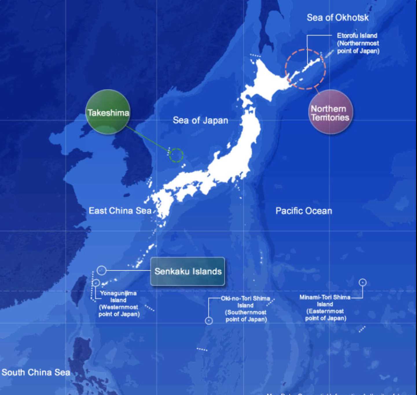
(Source: https://www.mofa.go.jp/territory/index.html)
National Museum of Territory and Sovereignty
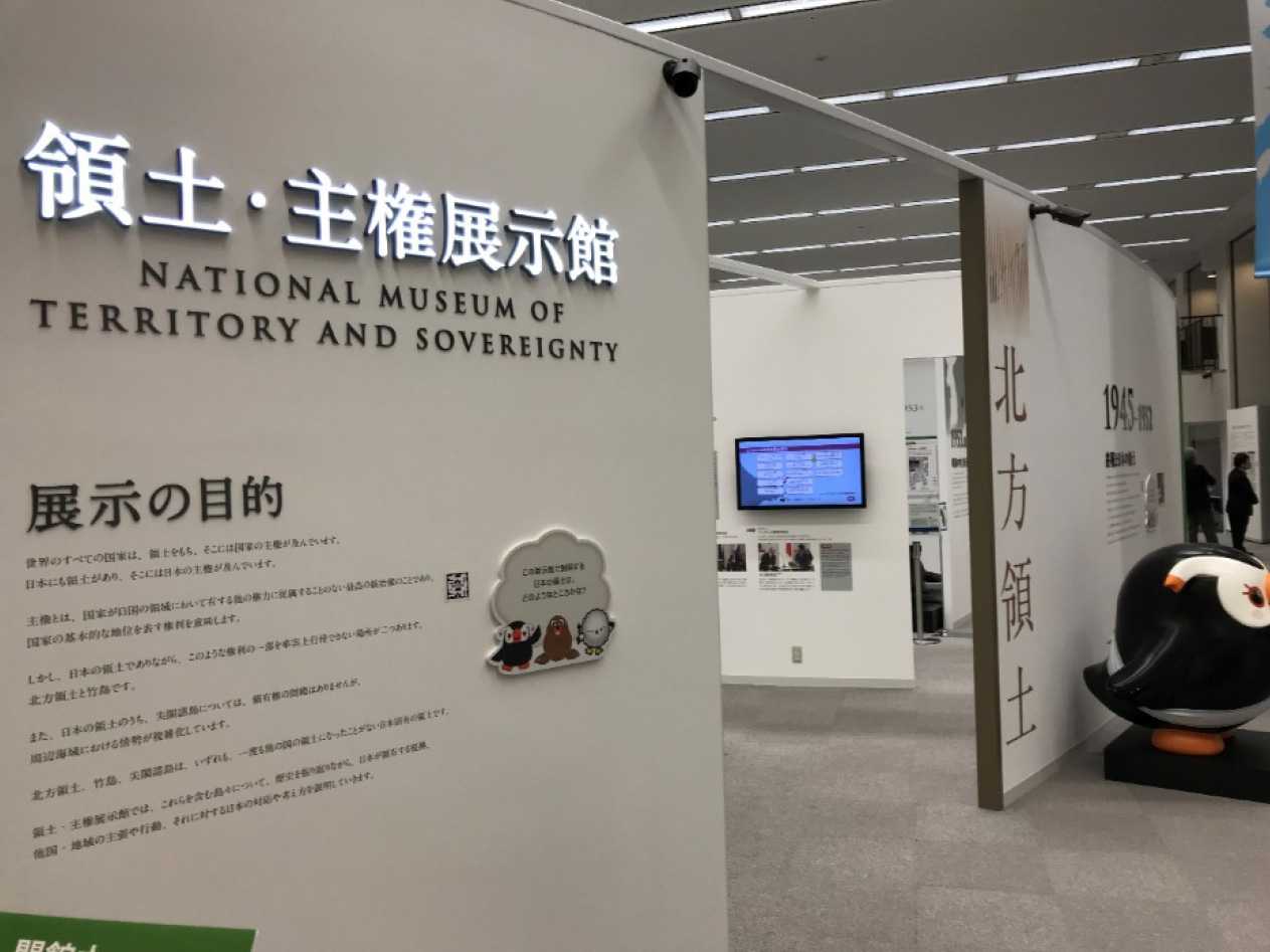
(Photo:TAKAI Susumu)
- Susumi Takai. “Shinsetsusareta Ryodo/Shuken Tenjikan” (The Newly Established National Museum of Territory and Sovereignty), Journal of Islands Studies, Vol. 2, No. 9, pp. 106-109.
-
The report and overview are available at https://www.cas.go.jp/jp/ryodo/img/data/teigen-eg.pdf (English);
https://www.cas.go.jp/jp/ryodo/img/data/teigen.pdf (Japanese) - https://www.mofa.go.jp/territory/index.html (English)
-
The contents before the renewal can be viewed at these pages in the current website of the Office of Policy
Planning and Coordination on Territory and Sovereign:
https://www.cas.go.jp/jp/ryodo_eg/ryodo/hoppou-kousei.html (Northern Territories),
https://www.cas.go.jp/jp/ryodo_eg/ryodo/takeshima-about.html (Takeshima),
https://www.cas.go.jp/jp/ryodo_eg/senkaku/about.html (Senkaku Islands)
The contents of the former Museum can also be seen at https://www.cas.go.jp/jp/ryodo_eg/tenjikan/takeshima.html
(former Museum-Takeshima), https://www.cas.go.jp/jp/ryodo_eg/tenjikan/senkaku.html (former Museum – Senkaku Islands) -
Website of the Office of Policy Planning and Coordination on Territory and Sovereignty
https://www.cas.go.jp/jp/ryodo/img/data/pamph-hoppou.pdf (Northern Territories pamphlet)
https://www.cas.go.jp/jp/ryodo/img/data/pamph-takeshima.pdf (Takeshima pamphlet)
https://www.cas.go.jp/jp/ryodo/img/data/pamph-senkaku.pdf (Senkaku Islands pamphlet) - The full text for the objectives of the exhibition is as follows. "All the states in the world have their own territories and possess sovereignty over them. Japan also has its own territory and possesses its sovereignty over it./ Sovereignty is the supreme right of administration that a state possesses within its territory without subjection to any other authority, and means a right that demonstrates the fundamental status of a state./ There are, however, two places in the Japanese territory where Japan cannot exercise a part of such right in reality; that is, the Northern Territories and Takeshima./ In addition, in the Japanese territory, although there exists no issue of territorial sovereignty concerning the Senkaku Islands, situations in the maritime areas surrounding the islands have become complex./ The Northern Territories, Takeshima and the Senkaku Islands are inherent territories of Japan, which have never been part of a foreign country. The National Museum of Territory and Sovereignty reviews the history of islands including them, and explains the grounds of their affiliation to Japan, the claims and actions of other states or a region, and Japan’s responses and views against them."
- Nobuyoshi Ashibe, Kempo (The Constitution) (1993, Iwanami Shoten), p. 37. There are also other ways of defining the term. An example is, in addition to (i) to (iii) above, citing the case of Item 8 of the Potsdam Declaration where sovereignty is used to mean "territorial rights" (territorial sovereignty) (Isao Sato, Nihonkoku Kempo Gaisetsu, Zentei Daiyonhan (Overview of the Constitution of Japan, 4th Edition) (1991, Gakuyo Shobo), p. 32).
- Soji Yamamoto, Kokusaiho Shinban (International Law, New Edition), (1994, Yuhikaku Publishing), pp. 270-272. The English translation in quotes is attempted only for this paper.
- Ibid pp. 266-267. Furthermore, with regard to the process of the establishment of a legal system in modern international society, p. 20 and thereafter.
- Ibid. p. 270 and also p. 125. The English translation in quotes is attempted only for this paper
- The full text is as follows: "In the history of Japan, there exists an event which largely influenced the entire territory of Japan: World War II. / Japan accepted the Potsdam Declaration and put an end to the War in August 1945, signing the Instrument of Surrender in September, by which Japan was placed under the occupation by the Allied Powers./ In September 1951, the Treaty of Peace with Japan, or the San Francisco Peace Treaty, was signed by 49 states./ By this Treaty, Japan renounced Korea, Taiwan, the Kurile Islands and others, whereas the Northern Territories and Takeshima were not included in such areas of renunciation, which thus reaffirmed that they were part of the territory of Japan./ The Treaty also treated the Nansei islands including the Senkaku Islands as the territory of Japan. They were placed under the administration of the United States as parts of Okinawa. The administration was returned to Japan approximately two decades later./ In April 1952, the Treaty entered into force, ending the Allied Powers’ occupation of Japan.."
- Page 1 (Para 3) of Enclosure 1 in Inventory of Commitments and Problems – Korea, Folder (12), “President’s Papers 1954 (8)-(15) [report of Van Fleet mission to the Far East],” White House Office, Office of the Special Assistant for National Security Affairs (Robert Cutler, Dillon Anderson, and Gordon Gray): Records, 1952-61. The copy is held in the repository of the National Diet Library (Located in Folder (12), p. 52).
-
FY2017 Commissioned Research Report on Archives of the Senkaku Islands, pp. 36-38.
https://www.cas.go.jp/jp/ryodo/img/data/archives-senkaku04.pdf - With regard to the map of the navigation route between Naha and Fuzhou, see Shigeyoshi Ozaki, "The Legal Status of the Senkaku Islands - The Course of the Islands' Inclusion in Japanese Territory and the Legal Basis for This (Part 1 of 2)," The Journal of Island Studies, Vol. 4, No. 2, pp. 17-24.
- FY2017 Commissioned Research Report on Archives of Senkaku Islands (Ibid. Note 13), pp. 17-19.
- Ibid. Note 2
- Ibid. Note 3.

Related Research

No article
Related Readings
No article
Info Library