 RSS
RSS|
This paper has been posted in multiple installments. The third and final part is displayed below; click on the links to jump to earlier parts. Part 1 Part 2 Part 3 |
(Continued from Part 2.)
3. China's and Taiwan's Claim of a Historical Right to the Senkakus: Developments Since 1971
B. Did the Senkakus Become Chinese Territory During the Qing Dynasty?
We can fully conclude from the examination of China's historical records in Section 3.A ("Were the Senkakus Part of China During the Ming Dynasty?") that the islands were not part of China during this period. In a nutshell, at a time when not even Taiwan was considered Chinese territory, it is inconceivable that islands farther offshore would have been part of China. Neither can Chen Kan's mission records be taken as proof of a "discovery" under international law. The natural conclusion from the preceding examination is that during the Ming Dynasty, the Senkaku Islands were not part of China.
How about during the Qing Dynasty? Did they become part of China during the ensuing period? An unequivocal recognition of such a fact would be absolutely essential for China to make any historical territoriality claims regarding the Senkakus. The 2011 article by Han-yi Shaw that I referred to in Part 2 attempts to show that while the Senkakus were not part of China during the Ming Dynasty, they became so during the Qing Dynasty.1 This is a very tenuous and, ultimately, unconvincing argument despite his efforts, for it rests on the premise that the Senkakus were historically recognized as geographical adjuncts of the island of Taiwan. Only if this can be unequivocally established would his argument hold that China automatically acquired the islands when Taiwan was formally incorporated into Chinese territory under the Qing Dynasty in 1684. As noted in the previous section, the primary evidence presented for the argument that the Senkakus were geographically part of Taiwan is the unremarkable passage diaoyu yu xiaodong xiaoyu ye (釣魚嶼 小東小嶼也) from the poem "Wanli Changge" in Riben yijian--a document that has hardly been considered an authoritative historical text in China. Inasmuch as xiaodong here has been shown not to mean Taiwan, the passage is not enough to support Shaw's claim that the Senkakus have historically been recognized as belonging to Taiwan.
In the section below, I will examine whether the Senkakus were truly recognized as belonging to China during the Qing period, looking primarily at texts from that period cited by Shaw.
(1) Wang Ji's Reference to a "Boundary"
Wang Ji, the second Qing envoy to Ryukyu, visited the kingdom in June 1683. This was the same month and year that the Qing court, in seeking to take possession of Taiwan (or more precisely, the western half of the island), dispatched a large fleet of naval vessels to force Ming loyalist Zheng Jing (son of Zheng Chenggong) on the Penghu Islands in the Taiwan Strait to surrender. In volume 5, titled "Shenyi [Divine Mystery]," of his Shi Liuqiu za lu (Miscellaneous Records of the Imperial Mission to Ryukyu), Wang Ji writes that having crossed Pingjia Shan and Diaoyu Yu, on the morning of June 25, he saw the island of Chi Yu (Chiwei Yu). The ship had reached Chiwei Yu without its passengers having seen Huangwei Yu. In the evening, they passed the jiao (郊, outskirts) (written elsewhere as gou [溝, trench]) through very stormy seas, prompting the holding of a ritual during which a live pig and sheep were sacrificed to the sea, and porridge made with 90 liters of rice were served as an offering. A paper ship was built and burned, gongs were sounded, and drums were beaten. Soldiers put on their armor and helmets and drew their swords, repeating for a while a set of motions that had them lie low along the sides of the ship as if to guard against an enemy. Wang Ji then asked someone on the ship what jiao meant, the answer to which was the "boundary between the inner and outer [中外之界, zhongwai zhi jie]" Wang further asked, "How do you tell where the boundary lies?" The reply was, "It's a rough estimate, but it's the area we have just passed, so it's not simply guesswork. We sacrificed an enormous amount of food to the goddess of the sea and also displayed our military valor, and that's why we were able to cross the boundary." The ship carrying Wang must thus have traveled for about 10 hours after reaching Chi Yu (Chiwei Yu) before crossing the jiao (gou), where the ritualistic ceremony was held. Wang writes of having been informed that jiao meant the "boundary between the inner and outer," but whether or not this refers to a border between states in the international legal sense--indicating the point at which China ends and Ryukyu begins--is open to question. China contends that it does and submits Wang Ji's logs as historic evidence of a natural boundary occurring along the Kuroshio Current between China and Ryukyu, with Chiwei Yu lying on the Chinese side of the divide. The author remains deeply skeptical of such an interpretation, and my reasons will be outlined in the following.
(a) Did Wang Mean a "National Border" in the International Legal Sense?
The waters just past Chiwei Yu is a confluence of the main Kuroshio Current flowing east of Taiwan and the branch to the west of the island; the current around Chiwei Yu was consequently very swift, and the seas were often quite rough, making the area difficult to navigate. The relatively shallow waters--with depths around 200 meters--above China's continental shelf suddenly give way to trenches 1,000 to 2,000 meters deep, and the color of the water turns from turquoise blue to deep black. This is precisely where "the water flows from cang shui [blue sea] to hei shui [black sea]," and for this reason it has also been referred to as Hei Shui Gou [黒水溝, black sea trench] or simply gou. The reference to jiao [郊] for this area is a usage seen only in Wang's records (with subsequent mission logs referring to gou), and it was most likely a reference to the ritualistic ceremony [郊祭, jiaoji] held to pray for safe passage (which later came to be commonly referred to as the gou-passing ceremony).
In ancient China, jiaoji was a ritual conducted by the emperor to pray for heaven (on the winter solstice) and earth (on the summer solstice) on the southern and northern outskirts of the imperial city, respectively. Jiao referred to the space around the outer walls delimiting the imperial capital in depopulated, border areas.2 In later years, the meaning of jiao expanded to include demarcations of certain territories in feng shui terms separating the inner and outer areas. This is what Wang Ji had in mind in applying the jiao concept to the sea, calling the Kuroshio confluence a jiao, a maritime boundary between the inner and outer (zhongwai zhi jie), separating the coastal and familiar cang shui from the dark-colored and unfamiliar hei shui of Ryukyu.
Incidentally, the reference to a zhongwai zhi jie boundary also appears in the mission logs of the first Qing envoy, Zhang Xueli, dispatched prior to Wang Ji. While Zhang makes no mention of jiao, he makes the same reference to a zhongwai zhi jie border zone. He writes of encountering the rough, difficult waters of dayang [大洋, great ocean] in the Taiwan Strait after two days of sailing from Fuzhou (believed to be a reference to a Hei Shui Gou in the strait), after which he comes upon a white stretch of sea running north-south that seems to separate the surface of the sea into two distinct areas. He reports that a crewmember thereupon announced that they have passed a division in the sea [分水洋, fenshuiyang] that the celestial deity has demarcated into the inner and outer. The border area referred to by Zhang Xueli would thus be much closer to the Chinese mainland--just past the Taiwan Strait--than that described by Wang Ji.
Wang describes jiao as being a desolate, almost ghostly area. It is the abode of the goddess of the sea, and those seeking safe passage must make offerings and show strength so as not to trigger the goddess's rage. Zhao Wenkai, the third Qing envoy after Wang Ji, who sailed to Ryukyu in 1800 (the records of the deputy envoy, Li Dingyuan are quite famous), wrote a long poem about passing Diaoyu Tai:3
As we passed Diaoyutai, the sea turned deep black. This Black Trench must not be taken lightly. One can hear a great roar from below, and a dragon hiding there may leap into the sky like a cloud and engulf us all. To appease the goddess of the sea and secure safe passage, live pigs and sheep must be thrown into the sea, and men must behave like soldiers about to fight a war. This will cause the clouds to dispel, and before us will appear Gumijima Island.
As these accounts suggest, passing the Kuroshio Current, known for its Hei Shui Gou, must have struck early Qing envoys to Ryukyu like Wang Ji--born in landlocked areas and unfamiliar with the sea--as an otherworldly experience. Making offerings to the goddess of the sea and securing safe passage became one of the most important tasks of the envoy. It was no doubt from such concerns that he named the Kuroshio Current not as a gou but as jiao carrying greater folkloric, feng shui connotations. This is also the reason the account appears in the volume titled Divine Fantasy, centered on the episode of a jiao ceremony.
Clearly, jiao and zhongwai zhi jie here did not mean territorial demarcations between states or national limits. (By zhongwai zhi jie, both Zhang Xueli and Wang Ji were referring to an area in the sea. In fact, there was no notion in seventeenth century East Asia that maritime or seabed features--such as the continental shelf--could determine the attribution of an island.)
Wang Ji, moreover, plainly distinguished between boundaries of maritime features and those of land territories, including islands, which involved attribution issues. This can be gleaned from the conversation he had aboard his ship: In response to Wang's question about why the Kuroshio Current was called jiao, the answer given was that it was the "boundary between the inner and outer." When further asked how the boundary was identified, Wang was told, "It's a rough estimate, but it's the area we have just passed, so it's not simply guesswork." In other words, the area in question was no doubt plain to see: a swirling torrent where the water's color turns from gentle green to a frightening deep black.
If, as China claims, jiao really meant the boundary between Chinese and Ryukyu territory, the reply would no doubt have been much simpler, such as, "The island we just passed is Chiwei Yu, which is part of China, and the one up ahead is Kumejima Island, belonging to Ryukyu." Clearly, neither Wang Ji nor his fellow travelers regarded the swirling Kuroshio Current as dividing Chinese and Ryukyu waters, and neither did they think that Chiwei Yu was part of China.
Wang Ji was well aware that Qing territory extended only as far as the islands along the mainland coast. According to Ishii Nozomu, among the collection of poems titled Guan hai ji by Wang was one that read Guo Dongsha Shan shi Min Shan jin chu (過東沙山 是閩山尽処), meaning, "once past Dongsha Shan, the territory of Min Shan comes to an end."4 Dongsha is one of the islands known today as the Matsu Islands, just 15 kilometers off China's coast, while Min is the ancient, poetic name for Fujian Province, and -shan refers to land territory, including islands. For the envoys traveling to Ryukyu during the Ming and early Qing Dynasties, Dongsha Shan represented the outer limits of Chinese territory. After Qing took control of the western half of Taiwan and set up a prefectural government there, Jilong (Keelung), at the northern tip of the island, became the eastern limits of the dynasty. Inasmuch as both Ming and Qing were continental states, they gave no thought to claiming remote islands, far from the coast, as part of their territory.
There is no mention of jiao or the "boundary between the inner and outer" in volume 2 of Wang's mission log (titled "Jiangyu" and detailing the territory of the Ryukyu Kingdom and dealing with issues far more relevant to international law than the "divine mysteries" described in "Shenyi" of volume 5). Rather, at the outset it describes Ryukyu as lying far in the distance, so many leagues beyond China as to be immeasurable, in a great sea. Clearly, then, China and Ryukyu do not have adjacent borders but are separated by a vast stretch of open sea.
The above also decisively debunks the argument that descriptions of the Kuroshio Current as the jiao and the "boundary between the inner and outer" in volume 5 of Wang's Shi Liuqiu za lu refer to a natural boundary between states; on the contrary, they are nothing but an attempt to explain a dangerous section of the sea route using feng shui and ritualistic terminology.
(b) Does Wang's Reference to a "Boundary Between the Inner and Outer" Constitute a Declaration that the Senkakus Are Chinese Territory?
As I noted in Part 1, unequivocally claiming, in international legal terms, that the Senkakus "became" part of China during the Qing (rather than Ming) period would require a clear expression (a declaration, for example) by the Qing government of an intention to occupy the islands and what can be presumed to be a demonstration that it never forfeited such claims (although there may be almost no need to have established effective occupation, given that the Senkakus were remote, uninhabited islands). Only with such a demonstration of continued possession could subsequent terra nullius claims be voided. Can Wang Ji's reference to the "boundary between the inner and outer," then, be regarded as a valid expression of the Qing's intent to occupy the Senkakus?
(i) This passage is not the Qing envoy's own declaration but simply a remark made by a fellow traveler (for whom no name, position, or even nationality is given) that Wang Ji jotted down, without adding any personal comments. As discussed in (a) above, the passage hardly corroborates claims that a boundary between China and Ryukyu existed at the Kuroshio Current at that time.
(ii) Another point not to be overlooked is that this passage in the Shi Liuqiu za lu--or Wang Ji's miscellaneous records--is completely missing from his Cefeng Liuchao (冊封琉鈔), the envoy's official report to the Qing emperor. Cefeng Liuchao includes all the official documents the envoy exchanged with Ryukyu officials, along with his comments to the emperor. There is a strong likelihood that the emperor personally read those comments. Noting that his voyage to Ryukyu was extremely safe and swift thanks to the blessings off the sea goddess, Wang petitioned the emperor to conduct festive rites for the goddess twice a year, in the spring and fall. The description of his voyage found in Cefeng Liuchao is nearly identical to that contained in the Shi Liuqiu za lu chapter on "Shenyi," but curiously, there is no mention at all of the shipboard exchange he had concerning jiao and the "boundary between the inner and outer" nor a description of the rituals performed. He no doubt refrained from conveying unconfirmed details to the emperor.5 ("Miscellaneous Records," in any event, is not a title one would normally give to a report of an official mission for the emperor's perusal. The document was no more than the personal notes kept by an imperial envoy.) Clearly, a passage that was removed from an official report to the emperor cannot be used as evidence of the Qing's intention to occupy the Senkaku Islands.
(iii) Further, Wang Ji's reference to the "boundary" was not treated with much importance by subsequent envoys. The next mission was made by Xu Baoguang, who did not run into the swirling current on this outward journey and consequently did not witness any rituals. Xu might have found this strange had he been familiar with Wang's accounts, but he makes no mention of the phenomenon, ignoring the "boundary" remarks. The next envoy, Zhou Huang, revised the errors contained in the records submitted by his predecessors in volume 16 of his Liuqiu guo zhi lue (琉球国志略), correcting, for instance, all of Wang's uses of jiao (郊) to gou (溝) (but leaving intact the "boundary" comments). All envoys after Zhou Huang have followed suit and used gou in their respective reports. Li Dingyuan, who followed Zhou, though, took issue with Zhou's reference to the Hei Shui Gou as demarcating the outer limits of Minhai (Fujian seas), denying the existence of a gou altogether, as I will address below. Li thus also negates Wang Ji's references to jiao and "boundary."
Of all the Chinese imperial envoys to the Ryukyu Kingdom, only Wang Ji talks of a jiao indicating a boundary. This observation failed to catch on with later envoys, though, and thus the author's conclusion is that it, in no way, is indicative of the Qing dynasty's intention to occupy all islands, including the Senkakus, west of the "boundary."
(2) Xu Baoguang's Reference to Ryukyu's Southwestern Limits
Xu Baoguang was the deputy to Haibao, the envoy of the third Qing mission to the Ryukyu Kingdom, dispatched in 1719. His mission log, published in 1721 as Zhong Shan chuan xin lu (Records of Messages of Zhong Shan), became a popular book that was widely read not only in China but also in Japan. In sailing to Ryukyu, his entourage reached Naha without actually passing by Diaoyu Yu, Huangwei Yu, or Chiwei Yu. But in the first volume of the work titled "Zhenlu" (Course), he gives a detailed description of his route from Fujian to Ryukyu. These are not first-hand accounts but quotes from the 1708 Zhinan Guangyi (指南広義), a book written by Ryukyu scholar Cheng Shunze. In his description of Gumi Shan (Kumejima Island), Xu inserts a note indicating that the island was a mountain to the southwest of Ryukyu guarding it near the sea border (琉球西南方界上鎮山). This is believed to have been based on information he received from Sai On, a renowned Ryukyu feng shui scholar and a member of the Council of Three royal advisors.6 China cites this passage as historical evidence that the Senkakus belonged to China, arguing that since Kumejima Island represented the western limits of Ryukyu, Chiwei Yu and all other islands beyond Kumejima were clearly part of China. This, however, can be shown to be a misreading of the text upon closer analysis.
The reference to 界上 southwest of Ryukyu in Xu's note does not refer to an area "above" (上) the border (界), as one might assume in a modern reading. In fact, Xu himself was aware that Ryukyu's true "southwestern border" was geographically much further west, near Yonagunijima Island in the Yaeyama Islands. This can be gleaned from the fact that he makes a geographically more rigid reference to Yaeyama as being Ryukyu's southwestern limits (琉球西南方界上鎮山) in volume 4 of his "Records of Messages," while referring to Gumi Shan merely as being "near" (上) the border.
Xu Baoguang's note regarding Kumejima Island is based on information he received from feng shui scholars in Ryukyu: that ancient Ryukyuans had inhabited islands as far west as , Kumejima Isand which served as the main guardian mountain for the kingdom's royal capital. According to feng shui teachings, a capital should have a guardian mountain in the back, in front of which stretches flat land.7 In the case of Ryukyu, which is an island kingdom, the beautiful island of Kumejima lying to the southwest of Shuri Castle and inhabited since antiquity by Ryukyuans was thought to be such a guardian for the capital. (Feng shui, in fact, was widely practiced on Kumejima.)
Xu's note was intended to elucidate Kumejima's propitious role in guarding the capital and not to demarcate the political boundary of the Ryukyu Kingdom. Just as Ming envoys Chen Kan and Guo Rulin, respectively, referred to Kumejima as "a Ryukyuan island" and being within "the boundary of the Ryukyu region," Xu also notes that Kumejima lies at the outermost limits of Ryukyuan-inhabited territory. This says nothing, though, about Diaoyu Tai, Huangwei Yu, and Chiwei Yu, which lie closer to the Chinese mainland. (They could, after all, have been [1] Chinese territory, [2] terra nullius not belonging to any state, or [3] Ryukyu territory but not described by Xu because they were uninhabited.) The only conclusion one can draw is that Xu's remarks hardly suffice to demonstrate Qing China's intention to occupy the Senkaku Islands.
(3) Zhou Huang's Reference to Hei Shui Gou Demarcating Minhai's Outer Limits
The mission records to be issued following Xu Baoguang's Zhong Shan chuan xin lu was Zhou Huang's 1759 Liuqiu guo zhi lue. Zhou was the deputy envoy of the fourth Qing mission to Ryukyu, headed by Quan Kui and dispatched in 1756. In volume 5 of Liuqiu guo zhi lue, Zhou writes: "Ryukyu is surrounded on all sides by the sea, and the waters to the west are demarcated by Hei Shui Gou, which marks the boundary with Minhai (海面西距黒水溝 與閩海界). To reach Ryukyu from Fujian unfailingly requires the crossing over from the turquoise to black sea." This is another passage often quoted by China to back its historical claims. Wu Tianying, for example, points to it as clearly indicating that Hei Shui Gou separates the seas of Ryukyu from those of Fujian. The reference to "Minhai," he asserts, corresponds to the seas off Fujian's coast that later became known as Donghai or the East China Sea, adding that the Diaoyu Islands, located above the seabed (continental shelf) west of Hei Shui Gou in the East China Sea, are unmistakably part of Chinese territory.8
Such a reading of Zhou's text, though, is at odds with orthodox interpretations of historical documents. The notion that those islands lying above a coastal country's continental shelf belong to that state was only recently established under the Law of the Sea. Applying this concept to the East China Sea in the eighteenth century is plainly an anachronism. At that time, the Qing's maritime territory extended only as far as several coastal islands (such as Dongsha Shan, or Matsu Islands, off Fujian). And the islands of the western half of Taiwan, which were newly annexed by the Qing, included only Jilong Yu. The Senkakus were not, as a historical fact, a part of the Qing.9
What should, then, be made of Zhou's reference to "Minhai"? This is a term that was originally used to describe the coastal seas of southern China around Fujian Province. If Zhou used the word to encompass a much broader area of the East China Sea, extending to just west of the Ryukyu Islands, he was clearly using it in a rhetorical or metaphorical sense, attaching meanings not normally associated with the term. Such irregular usage of the term hardly proves that the Senkakus were included as part of Minhai. A similar passage appears in a Xu Baoguang poem about the 36 islands of Ryukyu (contained in volume 15 of Zhou's Liuqiu guo zhi lue), in which Xu notes that the various islands are scattered around Minhai (琉球弾丸綴閩海). Does this mean that all Ryukyu Islands are part of China, as Wu Tianying might argue? Obviously not. These references to Minhai are simply rhetorical devices used--not without vanity--to emphasize the vastness of the sea (Minhai) surrounding the Qing, as compared to the confined waters of a minor island state on the other side of the Kuroshio Current. Jumping to the conclusion that all islands up to Chiwei Yu are part of China based on a literal interpretation of exaggerated and poetic rhetoric would be a most inappropriate reading of historical texts.
(4) Li Dingyuan and Nineteenth Century Envoys
Interestingly, these accounts in Zhou Huang's Liuqiu guo zhi lue were explicitly rejected by the next (deputy) envoy, Li Dingyuan, whose 1800 Shi Liuqiu ji recounts the following episode. One day, as Li was preparing for his return voyage from Naha, a banquet was held among Li, the chief envoy Zhao Wenkai, and other officials accompanying the mission from Beijing. During the feast, one of the officials asked Li: "In the waters west of Ryukyu, I've been told, lies Hei Shui Gou, marking the limits of Minhai. But the Ryukyuan people don't seem to know about this trench, and I don't recall passing it on our outward voyage. Why is that, I wonder?" To this Li Dingyuan replied: "Many have sailed the seas, but few have written about their journeys. Even fewer have sat at the helm day after day without getting seasick and jotted down everything they saw. A remark of a single writer may be quoted by many others, but how can we know whether such a comment is accurate? If the Ryukyuan people, who cross the sea each year, are unfamiliar with a so-called black trench, one may safely assume that it doesn't exist."10 If Hei Shui Gou itself does not exist, as Li Dingyuan argues, then, logically speaking, it cannot have marked the limits of Minhai.
Li Dingyuan's comments clearly negate the references by Wang Ji and Zhou Huang to a gou (or jiao) that served as a boundary between Chinese and Ryukyu waters. (While Li did not directly refute Wang Ji's comments about a jiao marking the "boundary between the inner and outer," he rejected Zhou's assertion that a gou--revised by Zhou from Wang's jiao--was the boundary between Minhai and Ryukyu seas.) It appeared customary for Chinese envoys to perform a sacrificial rite to ensure safe passage while crossing the Kuroshio Current west of Kumejima Island, both to and from their mission to the Ryukyu court, but the idea that this area marked a maritime boundary between China and Ryukyu did not take root (and neither was it regarded thus by the Ryukyuans, as Li's comments makes clear).
Another crucial fact that cannot be overlooked is a passage from the 1882 Xu Liuqiu guo zhi lue (続琉球国志略) by Zhao Xin--the final Chinese investiture envoy to Ryukyu. The mission log includes the routes taken by both Zhao (1866) and his predecessor, Lin Hongnian (1838). Earlier mission logs gave the Chinese names for such islands as Huangwei Yu and Chiwei Yu, but Zhao and Lin calls them by their Ryukyu appellations, namely, Kuba and Kumeaka, noting that he passed by the islands of Diaoyu, Kuba, Kumeaka, and Gumi (Kume). Zhao no doubt simply jotted down the names given by the Ryukyu sailors, but the fact that he used the Ryukyu names unequivocally shows that the two last envoys (Lin Hongnian and Zhao Xin) did not consider the islands to belong to China. This is an extremely important point to which I will come back at the end of this section.
(5) Huang Shujing and His Mission to Taiwan
The Tai hai shi cha lu (台海使槎録) was written in 1722 by Huang Shujing, the Qing court's high commissioner to Taiwan, who inspected the island and its adjacent waters and reported his findings. In volume 2, titled "Wubei" (Military Preparedness), Huang lists Taiwan's ports, giving their respective depths and indicating whether ships can enter and anchor there. All of the many ports cited as being part of the Qing at the time are mouths of rivers or bays on Taiwan's west coast (from Kaohsiung in the south to Keelung in the north). At the bottom of the list, though, are Hualien on the eastern side of Taiwan and Diaoyu Tai, located far offshore in the seas northeast of Taiwan. It is of great interest whether the Diaoyu Tai described by Huang is really what we today call Uotsuri Island (Diaoyu Dao) in the Senkaku Islands.
By this time, many Han Chinese had migrated to and settled in the western half of Taiwan, which was effectively under Qing control. Three counties--Taiwan, Zhuluo, and Fengshan--were established as part of Taiwan Prefecture. The eastern half of Taiwan (called Shanhou [山後], or "behind the mountains," lying, as it does, beyond the Central Mountain Range), though, was inhabited by indigenous people and considered by the Han to be barbaric territory--and for this reason was considered outside of Qing jurisdiction (化外). Huang's Tai hai shi cha lu notes that ports today called Tainan, Kaohsiung, Danshui, and Keelung were capable of accommodating Qing naval patrol boats, but other harbors were too muddy for large ships, their use being limited to sampans and other small fishing boats. Huang claims, though, that a dozen large ships may anchor at "Diaoyu Tai," lying far offshore in the seas north of the Shanhou district. (The same passage can be found in subsequent documents, including the 1747 Chongxiu Taiwan fu zhi [重修台湾府志] by Fan Xian, the 1764 Xuxiu Taiwan fu zhi [続修台湾府志] by Yu Wenyi, the 1835 Taiwan zhi lue [台湾志略] by Li Yuanchun, and the 1871 Chongzuan Fujian tongzhi [重纂福建通志] by Chen Shouqi. Indeed, volume 86 of Chongzuan Fujian tongzhi on coastal defense includes the incredible claim, in the section describing the Kavalan prefectural office, that Diaoyu Tai is capable of accommodating a thousand large ships!)
In the Senkaku dispute to date, China has often cited the passage from Tai hai shi cha lu as strong historical evidence that the Senkakus were part of Taiwan and were thus effectively under Chinese control. Such a line of argument is extremely suspect, however, as I will briefly (due to space considerations) explain below.
(i) First of all, what the document does reveal is that "Diaoyu Tai" was not part of Qing China. In 1722, when Huang Shujing wrote Tai hai shi cha lu, Qing sovereignty clearly did not even extend to the eastern, Shanhou half of Taiwan. Inasmuch as "Diaoyu Tai" lies far offshore in the seas north of Shanhou, "Diaoyu Tai" cannot possibly have been part of the Qing. This is precisely the reason that "Diaoyu Tai" and "Xuepolan" (Hualien) were added by Huang as an appendix, as the author was referring to Taiwanese territory outside of Qing jurisdiction. Far from supporting claims that the Qing controlled "Diaoyu Tai," Huang's Tai hai shi cha lu is an admission that the island was not part of the Qing at all.
(ii) Why then, skeptics might ask, was "Diaoyu Tai" mentioned at all? The fact is that Huang Shujing never actually traveled to the eastern coast of Taiwan or Diaoyu Tai but simply quoted stories told by local informants, no doubt out of a desire to impress the readers of his report to the court. All references in "Wubei," save for the appendix, are to ports along Taiwan's western coast. As Ishii Nozomu notes, neither patrols by warships, field surveys, nor inspections by military officials were conducted on the eastern side of Taiwan.11 This is the reason for the ridiculousness of the claim that a "dozen large ships may anchor" at Diaoyu Tai. Keelung itself, on Taiwan's northern edge, was barely just being developed at the time, so the Senkakus, located some 190 kilometer offshore, were nothing more than solitary islands in distant waters. They were surrounded by rough seas with many sunken rocks and coral reefs, making it difficult to land on or even approach. Had Huang actually visited the Senkakus, he would never have written that a "dozen large ships may anchor" there. The tall, masted ships used by the Qing navy could not possibly have survived the 190-kilometer journey to the Senkakus through seasonal winds and swirling tides, anchored at and encircled the islands, and then returned to Taiwan; indeed such missions were never undertaken. (Travel between Fujian and Ryukyu was timed to take advantage of the seasonal winds; ships sailed out to Ryukyu in the summer and returned in the winter, making just one round trip per year. It was impossible to go midway to the Senkakus and then sail back shortly thereafter.12) In any event, at a time when not even the eastern half of Taiwan was under Qing control, there would have been absolutely no need for Qing warships to patrol the waters around Diaoyu Yu, much further off the coast.
The Taiwan prefectural (and later provincial) government established by the Qing had absolutely no interest in islands north of Taiwan. Its main concerns were the development of the main island and the expansion of areas under its effective dominion. The arc of islands lying beyond Huaping, Mianhua, and Pengjia off the coast of Keelung (namely, the Banjia and Senkaku Islands) have historically always been considered to lie between coastal China and the Okinawa Islands and were never, even in China, thought to be part of Taiwan. At no time in history, in other words, have the Senkakus ever been considered a part of Taiwan; in fact, during the eighteenth and nineteenth centuries (as I will demonstrate in a future paper), the Senkakus came increasingly to be viewed as belonging to the Ryukyu group of islands.
(iii) There is another possible interpretation of Huang's reference to "Diaoyu Tai," which is that it refers not to Diaoyu Yu (Uotsuri Island) at all but an island much closer to Taiwan. As explained above, a large, masted Qing warship could not possibly have sailed to and anchored at Uotsuri Island, circled around it, and then returned to Taiwan, so Huang could have had a completely different island in mind when referring to "Diaoyu Tai." Huang describes ports mainly on the western coast of Taiwan, starting south in Fengshan County, moving north to Taiwan County, and then further north to Zhuluo County, appended with references to Diaoyu Tai, Hualien, and the eastern coast of Taiwan. This leads one to suspect that Huang believed Diaoyu Tai to lie not too far offshore, between Xiao Jilong (Keelung) at Taiwan's northern tip and Xuepolan (Hualien) midway on the eastern coast. This would make much more sense when analyzing Huang's passage as a whole. Then what was the island he was referring to? A logical assumption would be Mianhua, lying off the Keelung coast.
The Tai hai shi cha lu describes Diaoyu Tai as being located north of the seas off Taiwan's eastern coast. From Taiwan, however, Uotsurishima (Daioyu Yu) in the Senkaku chain is located east-northeast, while Yonagunijima Island, Ishigakijima Island, and other islands in the Sakishima Islands lie due east. When the Senkakus are considered as a whole--including Taisho Island (Chiwei Yu)--the island chain is better described as being east of Taiwan than north. Lying north, instead, is Mianhua (and beyond it, Pengjia). Mianhua, according to the Dai Nihon chishi (Geographical Description of Japan), is an island of precipitous cliffs reaching 55 meters above sea level.13 The surrounding seas are quite deep, so "a dozen large ships" may very well have been able to anchor there. It is relatively close to Taiwan, making it readily accessible for Qing naval vessels. Huang was therefore no doubt referring to Mianhua when he wrote of "Diaoyu Tai." Huang, in fact, was not the only one to make this mistake; many people in Fujian and the Han Chinese of Taiwan during the late Ming and early Qing Dynasties also appear to have called Mianhua (or Pengjia) "Diaoyu Tai," as suggested by the map in the late Ming Dynasty Chouhai tubian (1562), which gives "Diaoyu Yu" where Mianhua is located. This was also seen in late Ming-era coastal defense maps used by Mao Yuanyi and Shi Yongtu. Similarly, there are scholars who believe, based on the context in which it is referred and its actual description, that the island cited as "Diaoyu Yu" in Riben yijian is actually Pengjia Yu.14
Thus it was no doubt quite common for the people of Fujian and the ethnic Han of Taiwan--as the island developed--to refer to Mianhua (or Pengjia) as "Diaoyu Yu" or "Diaoyu Tai" (meaning "fishing island" or "fishing platform"). In terms of historical context, this was quite different from the "Diao[yu] Yu" spoken of by the Ryukyu seamen on ships carrying Ming or Qing envoys. Indeed, both Mianhua and Pengjia appear not unlike a pedestal on which someone fishing along the coast might sit. Another fact that must be remembered is that there are a number of locations around China called Diaoyu Yu or Diaoyu Tai. Historians note that Chinese sailors at the time would give islands serving as navigational landmarks Chinese names according to their physical characteristics, often in total disregard of what local people called them. So, just because the name Diaoyu Yu appears on a map does not mean it refers to the island that is today called Diaoyu Yu (Uotsuri Island) in the Senkaku Islands.
In short, the arguments presented in this section more than amply show that the Tai hai shi cha lu can in no way be presented as historical evidence that the Senkaku Islands belonged to China during the Qing Dynasty.
(6) Later Documents
(a) Qing-Era Annals of Fujian and Taiwan
That the Senkaku Islands were not part of China during the Qing Dynasty can be confirmed with an examination of official Qing-era annals. First of all, the islands were not under China's administrative control during the Ming or the Qing Dynasty, as plainly shown by Ming and Qing geographical histories of Fujian Province and Taiwan Prefecture. The 1684 Fujian tongzhi (福建通志) compiled by the Qing court makes no mention of the islands (in neither the maps of Fujian Province and the three counties of Taiwan Prefecture in volume 1 nor the accounts of the "plains" of volume 2, the "mountains and rivers" of volumes 4 and 5, and the "outer islands" of volume 64). The same holds true for the 1871 Chongzuan Fujian tongzhi, also compiled by the Qing court. (The "complete map of Fujian" in the first volume sets the eastern limits of the province at Jilong Shan (Keelung) in Taiwan Prefecture. None of the other maps in the first volume--showing Taiwan's mountains and other natural fortifications, inland waterways, Fujian's coastal defenses, and large and small ports and sea routes--refer to the Senkakus. Volume 4 on boundaries and volume 15 on mountains and rivers in Tamsui and Kavalan include nothing that would indicate that the islands were under the administrative control of Fujian Province.) Again, none of the other local historical records of Fujian--such as those detailing Luoyuan County (1614), Ningde County (1718), and Xiamen (1839)--that the author has actually examined refers to the Senkakus. It was only in 1684 that the western half of Taiwan found its way into China's maps, when it was established as a prefecture with three counties (Taiwan, Zhuluo, and Fengshan) under Fujian's administration.
The first annals of Taiwan--the 10-volume (plus introduction) Taiwan fu zhi--was compiled in 1696 by Gao Gongqian and others and was followed in 1712 by the Chongxiu Taiwan fu zhi (10 volumes, Zhou Yuanwen et al.); in 1742 by Chongxiu Fujian Taiwan fu zhi (20 volumes plus introduction), Liu Liangbi et al.); in 1747 by Chongxiu Taiwan fu zhi (25 volumes plus introduction), Fan Xian et al.); and in 1764 by Xuxiu Taiwan fu zhi (26 volumes plus introduction), Yu Wenyi et al. In all of these accounts, Jilong Yu (Keelung) is indicated as the northern limit of Taiwan, and not even nearby Pengjia, Huaping, and Mianhua--let alone the Senkakus--are mentioned as being under Taiwan's administrative control. Interestingly, while the last of these accounts--the Xuxiu Taiwan fu zhi--in volume 1 cites the islands within and outside the port at Keelung under the administration of the Tamsui prefectural office, namely, Da Jilong Yu (Keelung Yu), Tongpan Yu, Zhutai Yu, Xianglu Yu, Jixin Yu, and Qigan Yu, no mention is made of the Three Northern Islands. This is also observed in the 1717 Zhuluo xian zhi compiled by Zhou Zhongxuan and the 1871 Danshui ting zhi by Chen Peigui.15
This indicates that the three islands of Pengjia, Huaping, and Mianhua were not administered by the Taiwan government and thus outside the control of the Qing court. The Senkaku Islands, lying much further offshore than the Three Northern Islands, therefore, could not possibly have been part of Qing-controlled Taiwan Prefecture (which later became a province). Incidentally, the three islands came under Taiwan's control only after Taiwan was ceded to Japan. From this, too, it is clear that the Senkakus were not part of China during the Qing Dynasty.
(b) The maps of Huang chao zhong wai yi tong yu tu
China cites the maps of the 1863 imperial atlas, Huang chao zhong wai yi tong yu tu, showing the Senkakus (in the detailed map of latitudinal divisions East 1 to East 5 of the South 7 volume and the general map of the introductory volume) as strong evidence of their inclusion as Chinese territory during the Qing era (Wu Tianying16). The author believes otherwise, and in fact the maps can be read to indicate that the Senkakus are part of the Ryukyu Kingdom. (The publication, which is also referred to as the Atlas of the Great Qing Dynasty, was compiled by Hu Linyi and shows the maps of almost all of Asia, centered on the Qing. It was considered an authoritative map of China and also one of the most widely circulated.)17
Given the nature of the map, the inclusion of the Senkaku Islands can in no way be offered as proof that the islands were part of Chinese territory at the time. The atlas is centered on the "Great Qing Dynasty," but it also includes such neighboring territories as Japan, Ryukyu, Korea, and Vietnam (see general map, Figure 1-1). The detailed map (Figure 1-2) includes islands around Ryukyu, but there is no indication regarding which of these islands belong to the Qing and which to Ryukyu. Maps East 5 to East 2 (right to left) fairly accurately represent the relative positions of Okinawajima and Kumejima Island as well as the Miyako and Yaeyama island chains. Above (that is, north of) the string of islands are indicated, from right to left, Chiwei Yu, Huangwei Yu, and Diaoyu Yu. The general map, too, shows, in the bottom right corner, two or three unidentified islands to the left (west) of the Ryukyu islands and Gumi Shan (Kumejima Island) that, from their location, can be regarded as the Senkakus.
Figure 1-1. General map from the introductory volume of the Huang chao zhong wai yi tong yu tu
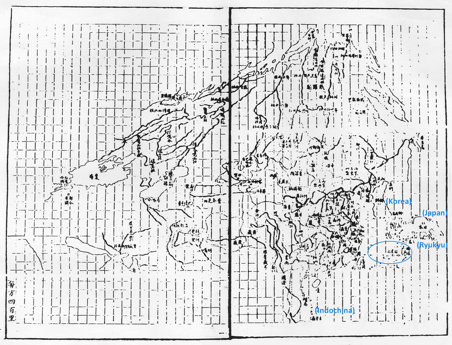
Note: The Senkakus appear as three to four unnamed silhouettes. The blue text and lines were added by the author.
Figure 1-2. Partial map (South 7 division, East 1 to East 5) of the Huang chao zhong wai yi tong yu tu
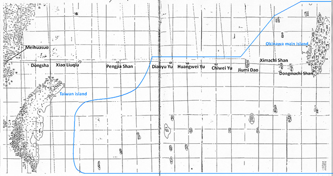
Note: The blue text and lines were added by the author.
In both of these maps, the Senkakus are just above (north of) and are much closer to the Ryukyu islands than to either Taiwan or the Chinese mainland. The first impression one gets, therefore, is that the Senkakus and the Ryukyus comprise a unit--strings of islands, one on top of the other. Because there is no indication of who has jurisdiction over the islands, most readers will no doubt conclude that the Senkakus belong to the Ryukyu Kingdom. While such a conclusion is at odds with that drawn by Wu Tianying, the two maps contained in the Huang chao zhong wai yi tong yu tu suggest that the Senkakus were regarded by Qing China readers as being part of Ryukyu. (In fact, the detailed map shows even Pengjia Shan as being closer to Ryukyu than Taiwan, above one of the Yaeyama Islands, quite possibly Iriomotejima Island.)
To be more precise, both the general and detailed maps show the islands (from the Okinawan port of Naha in the east to Dongmachi Shan, Ximachi Shan, Jiumi Dao (Kumejima Island), Chiwei Yu, Huangwei Yu, Diaoyu Yu, Pengjia Shan, Xiao Liuqiu (Jilong Yu), Dongsha and Meihuasuo in almost a straight line, connected by dots. This is more a conceptual--rather than geographical--representation of the sea route from Naha to Fujian. In any event, the dotted line indicates nothing regarding jurisdiction. Contrary to the claims by Wu Tianying, the fact that the Senkaku Islands--including Diaoyu Yu, Huangwei Yu, and Chiwei Yu--are shown with Chinese names does not in itself prove that they belonged to China, as I have already demonstrated in the section on the mission logs by envoys Chen Kan and Guo Rulin.18
The conclusion, then, of section (b) is that the Huang chao zhong wai yi tong yu tu does not offer any proof that the Senkakus were part of Chinese territory during the Qing dynasty.
(c) Zhao Xin's 1882 Xu Liuqiu guo zhi lue
The final Chinese investiture envoy mission to Ryukyu was made in 1866 by Zhao Xin, who in 1882 compiled a log titled Xu Liuqiu guo zhi lue detailing the routes taken by both Zhao and his predecessor, Lin Hongnian, in 1838. Lin's mission log has been lost, but passages are quoted by Zhao, among them being:
The mission entered the high seas from the port of Wuhumen on the fourth day of the fifth month of 1838, Banjia Shan (半架山) coming into view to the south shortly past noon of the fifth day and traversing past Diaoyu Shan (釣魚山) around midday of the sixth and Kuba Island (久場島) later in the afternoon. . . . We reached Kumeakashima Island (久米赤島) around dawn of the seventh day and Gumi Dao in the morning of the eighth.
As for Zhao's 1866 journey, he writes:
We set out to sea on the ninth day of the sixth month, passing Banjia Shan (半架山) in the late afternoon of the tenth and Diaoyu Shan (釣魚山) in the evening of the eleventh. Later that night we passed Kuba Island (久場島) and sailed past Kumeakashima Island (久米赤島) in the early afternoon of the twelfth, reaching Gumi Dao in the morning of the fifteenth day.
What is interesting about these two passages is that they give the Ryukyu names for久場島and久米赤島islands (J: Kubashima and Kumeakashima) that, in all previous official Chinese (Qing) mission logs, had been referred to Huangwei Yu (黄尾嶼) and Chiwei Yu (赤尾嶼); 久場島and久米赤島 are cited alongside names of other Ryukyu territories as Gumi Dao, Machi Shan (馬歯山), and the port of Naha, offering indisputable proof that China did not consider the islands as part of its territory and also that it had no intention of annexing them.
(d) The Figures and Tables of the 1889 You li Riben tu jing
The You li Riben tu jing was a survey report, published in 1889, written by a young and promising Qing bureaucrat named Fu Yunlong during his stay in Japan. Making use of many figures and tables, he presented a basic overview of Japan's history, government system, politics, foreign policy, economy, and institutions.
Fu passed the Qing diplomatic inspection exam with the highest marks and traveled to six countries--Japan, the United States, Peru, Brazil, Canada, and Cuba--on a survey mission between 1887 and 1889. He lived in Japan for over a year and compiled a detailed report, which was highly regarded by the Qing court, as indicated by the seal certifying that it was read by the Guangxu Emperor.19 In two sections, the report clearly identifies the Senkaku Islands as belonging to Japan. The first is in the table of Japan's southern islands in chapter 6 of his treatise on Japan, which, alongside other Okinawa islands, cites Senkaku Gun (尖閣郡 = Senkaku Islands) and Chiausu (低牙吾穌 = Kuba Island) (Figure 2-1). It should also be noted that they are listed as islands (J: shima, Ch: dao) in the Japanese style, rather than the Chinese yu (isle). The second mention of the Senkakus is in the general map of Japan at the head of the report, which clearly cites Chiausu, the Senkaku Islands of Uotsuri, Minamikojima Island, and Kitakojima Island, and Raleigh Rock (爾勒里岩 = Kumeakashima Island) (Figure 2-2) as being among Japan's southern islands.
Figure 2-1. Island list for Japan's southern territories in You li Riben tu jing
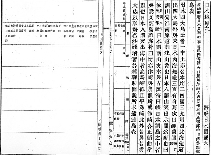
Figure 2-2. General map of Japan in You li Riben tu jing
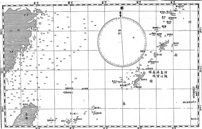
It is an indisputable fact that the You li Riben tu jing, written by a Qing official and submitted in 1889 to the court (which approved and published it)--ahead of the Japanese cabinet decision to annex the Senkakus in 1895--recognizes the Senkakus as being Japanese territory.
In sections (a) to (d) above, I have reviewed several late Qing-era documents, which show that from the mid- to late nineteenth century, the Chinese government clearly recognized that the Senkakus were not part of its territory and that, one may surmise, it expressed tacit understanding of the fact that they formed part of the Ryukyu Islands.
Based on the arguments advanced in Part 3 of this paper, one can draw the following conclusions. One is that Qing-era documents contain no direct evidence that the Senkakus became part of China during the Qing dynasty. While these documents do contain passages that can be taken to infer such a development, there are generally vague and metaphorical and can in no way be regarded as unequivocal proof. Nor is there conclusive evidence that the Senkakus were seen as being part of Taiwan--by the government or the people of China--at any time during the Qing dynasty. China has long history as a unified empire and, by nature, was very sensitive to its boundaries and outer limits. When acquiring new territory, therefore, it unfailingly issued regional annals to support those claims (such as for the northeastern region of Taiwan inhabited by the aboriginal Kavalan tribe in 1810 and for Orchid Island off Taiwan's southeastern coast.20 But no Qing document exists for the Senkaku Islands. On the contrary, Ryukyu and Japanese literature and maps, as well as those of Western countries, dating from the eighteenth and nineteenth centuries overwhelmingly suggest that the Senkakus were geographically regarded as part of the Ryukyu Islands.
Even when referring to only Chinese historical documents, therefore, one can definitively conclude that the Senkaku Islands were never part of China during the Ming and Qing dynasties. Nor were they seen as part of Taiwan, either by the Chinese government or the Chinese people (and they were certainly not geographically part of Taiwan).
Finally, one can safely conclude, at the very least, that the Senkaku Islands in 1895 (or more accurately, in 1885) were terra nullius under international law. The reason I say "at the very least" is because in 1885, when Japan launched an official survey of the Senkakus, if any nation had a legal (and historical) claim on the islands, it was Japan, for it had annexed the Ryukyu Kingdom and had thus established legitimate prior occupation and effective control over the islands. This is a subject that I will deal with in a separate paper.
Recommended citation: Ozaki Shigeyoshi, "The Senkaku Islands and Japan's Territorial Rights," Review of Island Studies, February 14, 2014, /islandstudies//research/a00009/. Translated from "Senkaku Shoto to Nihon no ryoyuken," Tosho Kenkyu Journal, Vol. 2 No. 2 (April 2013), pp. 6-33; published by the OPRF Center for Island Studies.
- See part 2 of this paper: Ozaki Shigeyoshi, "The Senkaku Islands and Japan's Territorial Rights," Review of Island Studies, June 10, 2013, /islandstudies//research/a00004/. Translated from "Senkaku Shoto to Nihon no ryoyuken," Tosho Kenkyu Journal 2, no. 1 (October 2012), pp. 8-27; published by the OPRF Center for Island Studies. [↩]
- Ishii Nozomu, "Senkaku Chogyo Retto zassetsu yonshu" (Four Miscellaneous Hypotheses Regarding the Senkaku-Diaoyu Islands), Junshin Journal of Human Studies 19 (2013), pp. 209-11. See also the Dai Kan-Wa jiten (Unabridged Han-Japanese Dictionary). [↩]
- I referred to a quote from Kishaba Kazutaka, "Senkaku Shoto no enkaku to kizoku mondai" (The History of and Territorial Disputes over the Senkaku Islands), Kaijishi Kenkyu, 20 (1973), pp. 64-65. [↩]
- Ishii, "Senkaku Chogyo Retto," p. 209. Regarding Guan hai ji , the collection of verses by Wang Ji, see Fuma Susumu, ed., Zotei Shi-Ryukyu-roku kaidai oyobi kenkyu (A Bibliographical Introduction to and Research of the Mission Logs by Imperial Chinese Envoys to Ryukyu, Enlarged and Revised) (Ginowan, Okinawa: Yoju Shorin, 1999), pp. 82-84. [↩]
- See the the online essay, "Senkaku-note, Senkaku Shoto mondai II" (Senkaku Notes: On the Senkaku Islands Issue II), entry 3.2.5.3, at http://senkakujapan.nobody.jp/page099.html (accessed on February 3, 2014; in Japanese). [↩]
- Kishaba, "Senkaku Shoto," p. 49. [↩]
- Horigome Kenji, "Fusui shiso to toshi no kozo" (Feng Shui and the Structure of Cities) in Watanabe Yoshio and Miura Kunio, eds., Fusui Ronshu (Tokyo: Gaifusha Publishing, 1994), pp. 158-59, 166-67. [↩]
- Wu Tianying, Kogo senzen, pp. 65, 68. [↩]
- Ishii, "Senkaku Chogyo Retto," p. 208. [↩]
- Li Dingyuan, Shi Liuqiu ji (1800), entry in vol. 6 for the sixth day of the tenth month , 1800. [↩]
- Ishii Nozomu, "Wakun senkai: Senkaku Tsuriuo Retto kanbun shiryo" (Chinese Language Materials on the Senkaku Islands) (Nagasaki Junshin Catholic University Institute of Comparative Cultures, 2012), p. 164. [↩]
- Ishii, "Senkaku Tsuriuo Retto," p. 200. [↩]
- Yamasaki Naomasa and Sato Denzo, co-editors, Dai Nihon chishi (Geographical Description of Japan), vol. 10 (Tokyo: Hakubunkan, 1915), pp. 220-21. [↩]
- See "Senkaku-note," entry 3.2.4, which points out that the author of Riben yijian mistook Pengjia Shan for Diaoyu Yu and believed the Senkaku Islands (Diaoyu Yu) was Huangma (Huangwei) Yu. [↩]
- Ozaki Shigeyoshi, "Senkaku Shoto no kokusaihojo no chii: Shu to shite sono rekishiteki sokumen ni tsuite" (The Status of the Senkaku Islands in International Law: Concerning Mainly Their Historical Aspect), Tsukuba Hosei 18, no. 1 (1995), pp. 226-28. [↩]
- Wu Tianying, Kogo senzen, pp. 102-104. [↩]
- Ikeuchi Hiroshi, Yano Jin'ichi, Hashimoto Zokichi, and Hamada Kosaku, chief eds., Toyo rekishi daijiten (Unabridged Dictionary of Asian History), condensed edition, vol. 2 (Kyoto: Rinsen Book Co., 1986), p. 462. [↩]
- Ozaki, "The Senkaku Islands and Japan's Territorial Rights," part 2, 3.A.1(a) and (b). [↩]
- Wang Baoping, "Fu Unryu no Nihon kenkyu no shuhen: Sono chosho o megutte" (The Circumstances surrounding Fu Yunlong's Study of Japan ), in Fujiyoshi Masumi, Sekko to Nihon (Suita, Osaka: Kansai University Press, 1997), pp. 227-28, 233-34, 241-45. [↩]
- Fan Xian, Chongxiu Taiwan fu zhi, in Department of Economic Research, Bank of Taiwan, eds., Taiwan wenxian congkan (Taiwan Literature Series) 105 (Bank of Taiwan, November 1961), p. 52. [↩]
Professor emeritus at the University of Tsukuba. Specializes in international law. Born in 1936. Graduated from the University of Tokyo, where he majored in law. Received his doctorate from the Division of Law and Politics, University of Tokyo Graduate School. Worked in the Research and Legislative Reference Bureau of the National Diet Library. Has served as a professor in the Faculty of Law, Niigata University; the Institute of Social Sciences, University of Tsukuba; and the Faculty of International Political Science and Economics, Nishogakusha University. The following are his main works on the Senkaku territorial issue: 1. “Senkaku Shoto no kizoku ni tsuite” (Territorial Sovereignty over the Senkaku Islands), pts. 1, 2, 3-1, and 3-2, Reference nos. 259 and 261–63 (1972). 2. “Senkaku Shoto no kokusaihojo no chii: Shu to shite sono rekishiteki sokumen ni tsuite” (The Status of the Senkaku Islands in International Law: Concerning Mainly Their Historical Aspect), Tsukuba Hosei 18, no. 1 (1995). 3. “Territorial Issues on the East China Sea: A Japanese Position,” Journal of East Asia and International Law 3, no. 1 (2010). 4. “Senkaku Shoto to Nihon no ryoyuken,” published in three parts in Tosho Kenkyu Journal, Vol. 1 (June 2012), Vol. 2 No. 1 (October 2012), and Vol. 2 No. 2 (April 2013); published by the OPRF Center for Island Studies. Translated as “The Senkaku Islands and Japan’s Territorial Rights,” Review of Island Studies, June 10, 2013, http://islandstudies.oprf-info.org/research/a00001/.
Related Research

U.S. Recognition of Japanese Sovereignty Over the Senkaku Islands
Raul(Pete)Pedrozo (Sep 15, 2022)
Protest and Acquiescence in Territorial Acquisition: In relation to the Senkaku Islands
MIYOSHI Masahiro (May 01, 2018)
International Law and Japan's Territorial Disputes
Raul (Pete) Pedrozo (Feb 06, 2018)
The Senkaku Islands as Viewed through Chinese Law
SAKAMOTO Shigeki (Sep 12, 2016)
Related Readings
TAKAHASHI Noritsugu (Sep 15, 2022)
TAKAI Susumu (Sep 15, 2022)
CHIBA akira (Sep 27, 2021)
Notes on David Helliwell's "The Clashing Rocks"
ISHIWI Nozomu (Sep 12, 2016)