 RSS
RSSThe Legal Status of the Senkaku Islands (Part 1)
Their Inclusion in Japanese Territory and the Legal Basis for This
Jan 23, 2015 PDF Download
|
This paper will be posted in multiple installments. Part 1 is displayed below. Part2 will be uploaded in the next issue.
|
1. Introduction
In my essay "The Senkaku Islands and Japan's Territorial Rights," published in three parts on this website,1 I examine the relevant history and set forth my proof that the Senkaku Islands were never a part of the territory of China (either Ming or Qing). In the conclusion of part 3 of that essay, I state:
Even when referring to only Chinese historical documents, therefore, one can definitively conclude that the Senkaku Islands were never part of China during the Ming and Qing dynasties. Nor were they seen as part of Taiwan, either by the Chinese government or the Chinese people (and they were certainly not geographically part of Taiwan).
Despite the presence of such clear historical and geographic facts, the Chinese government continues to boldly make baseless claims in the international arena, such as before the United Nations General Assembly, stating that the Senkakus were historically Chinese territory and that Japan "stole them" from China in the tumult of war. One can only be astonished at this shamelessness. Setting all this aside, though, if we are certain that the Senkakus were not historically a part of China, then according to international law they must have been either terra nullius or else part of the territory of the Ryukyu Kingdom. (There were no other nations that ever indicated territorial claims to the Senkakus during this entire period.)
As I will make clear below, the early modern Ryukyus2 had vastly deeper ties with the Senkaku Islands than any other nation, China included. (This was also the view of the countries of the West at the time, as I will show later in this paper.) However, the Ryukyu Kingdom did not itself consider the Senkakus to be part of its territory. (Indeed, during this era, nations throughout East Asia did not view lonely islands in remote seas unfit for human residents--in short, desert islands--as belonging to any state.) This means that during this period, from the perspective of international law, the Senkaku Islands were clearly not part of the Ryukyu state. It is therefore correct to declare that the islands were terra nullius in terms of international law until 1895, when the Meiji government incorporated them into the territory of Japan.
While I agree with this, there is one point on which I hold some reservations. Namely, from the eighteenth through the nineteenth centuries, although the Senkakus were not formally a part of the Ryukyu territory according to legal convention, they were a historical (or traditional) territory of the kingdom. In short, while the Ryukyu government did not express the intent to possess the islands, for many long years--more than two centuries at least--it did exercise actual control over the islands on a scale dwarfing that of any other nation's relationship with the islands. This control was so effective that if the kingdom (or the Japanese state, which took its place thereafter) had at any point decided to formally take possession of the islands, it could have done so right away by merely indicating its intent to do so. And this indication of intent eventually came in the form of the 1895 decision to incorporate the Senkaku Islands into the territory of Japan. This is my take on the matter: the 1895 cabinet decision was a way for the nation to take steps to change a historical territory, which had not been subject to displays of intent to control, into a national territory in the eyes of international law. (I believe this was the reason that the January 14, 1895, cabinet decision granted permission to erect markers showing the islands as prefectural [i.e., Okinawan] territory, rather than signposts indicating national ownership, as had been the case with the Daito Islands in 1885. I will revisit this point in detail in the second part of this essay.)
In this way, I cannot view the process by which Japan made the Senkakus part of its territory as a classic example of the principle of "discovery and occupation,"3 the standard grounds for territorial claims under the international law of the nineteenth century. Rather, my belief is that these islands were formally incorporated into the national territory (in a domestic legal sense, rather than according to international law) after long years of their existence as historical territory; I will compose this essay along the lines of this understanding.
2. The Ryukyus and Senkaku Islands Through the Early Modern Era
A. Geographic Position of the Senkaku Islands
An important point that must not be missed here is that the Senkaku Islands are closer to Okinawa's Sakishima Islands (which include the Yaeyama and Miyako island chains) than to any other location. This is significant for several reasons. To confirm this geographic fact, we can measure from the westernmost of the Senkakus, Uotsuri Island, and find that it lies roughly 380 kilometers from continental China. It is 410 kilometers from the port of Naha on Okinawa Island (and some 100 kilometers closer if we measure from Kumejima Island, west of Okinawa) and 170 kilometers from Ishigakijima Island in the Yaeyamas--or an even shorter distance, 150 kilometers, from Yonagunijima Island in that same chain. Uotsuri is around the same distance, 170 kilometers, from the port of Keelung in northern Taiwan.
We must note, however, that this distance to Taiwan can be largely ignored in terms of the historical record. Firstly, during the Ming dynasty (1368-1644), Taiwan had yet to be included in maps of China; the distance from Taiwan to islands still farther away was therefore clearly irrelevant. Next, during the Qing dynasty (1644-1912), even after Taiwan came under the sway of the Qing rulers in 1683, their rule extended only to the plains in the west of the island. The regions to the north, including Keelung, and on the eastern shore were not ruled by the Qing until much later in that historical era, when they came under control along with Taiwan's mountainous center. Prior to that, they remained "outside the realm."
Huaping, Mianhua, and Pengjia, three small islands off of Taiwan's shore to the north of Keelung, were not included on official Qing maps for the duration of the Qing dynasty. The Senkaku Islands, located even farther away than these, were not a place visited by Chinese or Taiwanese aboriginal peoples. The seas surrounding the Banjia Islands (the three islets named above), some 56 kilometers north of Taiwan's northern tip, were globally renowned as a difficult area to navigate (as was detailed in The Journal of Jean-François de Galaup de la Pérouse 1785-1788). At this location the mainstream of the Kuroshio Current, which comes up from the Philippine seas along Taiwan's east coast, rejoins the secondary stream passing along the west coast through the Taiwan Strait. Here it also meets the edge of the continental shelf extending from the Chinese mainland and the water depth increases rapidly. This makes for violent currents and whirlpools, rapid shifts in weather, and sudden strong winds. In his Narrative of the Expedition of an American Squadron to the China Seas and Japan, US Commodore Matthew Perry notes that he sailed into the waters north of Taiwan and confirmed the fierce currents there. The seas around the Banjia Islands also contain numerous sunken reefs. Vessels were thus in danger of wrecking if a strong wind picked up and blew them toward the islands. Chinese people therefore did not approach these islands, preferring to view them from afar. The seas beyond there, around the Ryukyus, also featured numerous reefs and complex currents, as well as fast-changing weather, making them dangerous seas to sail. China's marine merchants had little interest in trade with the resource-poor Ryukyus in the first place, and the Chinese made almost no moves to make use of these seas, especially during the Qing era. Thus, the Han Chinese who had moved to Taiwan did not travel to the area around the Senkaku Islands, far to the northeast of their island.
Moreover, throughout the entire Qing era, almost no Chinese ships used the sea route from the mainland to Okinawa via the Senkaku Islands, with the exception of eight vessels carrying imperial envoys on missions to the Ryukyus. (Ships traveling from the continent to Japan took a more westerly route that did not go near the Senkakus.) It is no exaggeration, therefore, to say that by the time of the Qing dynasty, the Senkaku Islands had all but vanished from the sight of the Chinese. Meanwhile, though, during the more than two centuries of the Qing era, approximately 1,000 Ryukyuan vessels are said to have sailed to the Chinese mainland,4 with the Senkaku Islands invariably along their route.
When considered in this light, it was Okinawa's Sakishima Islands--in particular Yonagunijima, Iriomotejima, and Ishigakijima Islands--that were far and away the closest territories to the Senkaku Islands, geographically, throughout the Ming and Qing dynasties. In addition to this geographic position, when we consider the above-mentioned presence of the Kuroshio, the strong current flowing through the seas around the Senkakus, seasonal winds and typhoons, and other natural conditions, it becomes clear that the Yaeyama Islands, including the Miyako Islands and Ishigakijima Island, and Yonagunijima Island to the west form a single ecological sphere with the Senkaku Islands stretching to the north and northeast. Therefore, we can also see the formation of a commonality of livelihood and culture (which Nishizato Kiko terms the "regional sphere of livelihood") covering this entire territory. Yonagunijima Island, for instance, is connected to Uotsuri Island in the Senkakus, to its north, by the northward-flowing Kuroshio. A vessel catching favorable winds out of the south could, even centuries ago, arrive at Uotsuri Island in about half a day.
Under these geographic and natural conditions, completely different from those facing the Chinese on the continent, we can surmise that the islanders on Ishigakijima, Yonagunijima, and Miyakojima Islands made use of the Senkaku Islands, fishing there and using them to shelter from typhoons or sudden gales and visiting them frequently during journeys to Okinawa Island (or to points beyond, like the main Japanese islands or Korea), China, and the countries of the South Seas. (Uotsuri, Minamikojima, and Kitakojima Islands do not have such rough waves on their southern shores, making them easy to approach from that direction.) This is something that can be readily gleaned from the fragmentary historical records that are available.
Let me give a few examples. First, as is well known today, in the early fourteenth century (1317 to be precise), two vessels carrying 60 Miyakojima islanders were on a journey that took them to the southern tip of the Malay Peninsula, near what is today Singapore, to trade. During the return leg, they met fierce wind and rain and washed up on Yangong, an island in what is now Yongjia, Zhejiang Province, where they were rescued by local officials. (This is recorded in the imperial biography of the Emperor Renzong in the 1370 Yuan shi [History of Yuan] and the Wenzhou fu zhi [Record of the Government of Wenzhou], a text reconstructed in 1605.) We can presume that these Miyako vessels passed by Uotsuri Island in the Senkakus during these round-trip voyages. Uotsuri was, in a way, the northern "exit" for people on the Sakishima Islands (Yaeyama and Miyako) embarking on their journeys.
Second, in 1389 the Ming government began relations with the Ryukyus and Korea. A historical record of Korea's House of Yi, the Yijo Seongjong taewang sillok (Annals of King Seongjong of the Yi Court), describes an incident when residents of Jeju Island were shipwrecked on Yonagunijima Island. This is the oldest historical record to mention Yonagunijima Island, or indeed the Sakishima Islands as a whole. It includes a passage that shows how already during this era the Yonagunijima islanders traveled freely to and from the Senkaku Islands. The historian Kadena Sotoku describes this passage as follows:
Once a navigation point used during sea voyages, Diaoyu Yu [Uotsuri Island] was to the Chinese nothing more than a waypoint to pass by during a journey. For the Ryukyuans, though, this was a familiar stop known as Kubashima, with rich water supplies, and at times they would land here to take on water. On the first day of the second month, 1477, 10 Jeju islanders including Kim Bi-ui (金非衣) left Jeju with a cargo of citrus fruit to take to Gyeongseong [Seoul] as an offering. But as they approached the island of Chuja, some 15 ri [60 kilometers] to the north, a strong easterly wind arose, and their damaged ship was swept away farther and farther to the west. On their ninth day adrift, the wind shifted and came violently out of the west, and they were swept far to the south. On the fourteenth day they spied a small island from afar and directed their vessel toward it in an attempt to land. Just before making shore, though, their ship was destroyed. Seven of the Koreans drowned and the remaining three clung to flotsam among the waves. Luckily, after several days adrift like this, they were rescued by two fishing vessels out of Yonagunijima Island, taken to a seaside tent (a temporary shelter on the shore), and cared for. And where was this tent? There were trees, kuba [Livistona palms], and plentiful water here. This shelter must have been built on Uotsuri Island. At the time, there were metalworkers on Yonagunijima Island, and the islanders are believed to have traveled back and forth to Fuzhou. Their sailing techniques could easily have expanded the range of their fishing grounds as far as the Senkaku Islands.5
As can be seen from this historical document, well before the Ming envoy Chen Kan's 1534 journey to the Ryukyus, the Ishigakijima and Yonagunijima islanders were making frequent trips to fishing grounds toward Uotsuri Island, where they even built temporary structures from time to time.
Third, there is a yunta, or traditional song, that was sung by the Yonagunijima islanders as late as the Taisho period (1912-26) that showed how they had known of the Senkaku Islands (Uotsuri Island) since antiquity. The song, called "Suyurigi," was sung at festivals to celebrate bountiful harvests and at festivities held in local communities. At the urging of the famed folklorist Yanagita Kunio, the folklorist Motoyama Keisen went to Yonagunijima Island from the end of 1923 through the spring of 1924, publishing the lore he collected in his 1925 Yonagunijima zushi (Illustrations of Yonagunijima Island). This was the first scholarly work on Yonagunijima--and indeed, until recent years, the only one. (This work was one volume of the 36-volume Rohen sosho [Hearth Series] published by Yanagita; it is also reprinted in Nihon minzokushi taikei I: Okinawa [Survey of Japanese Folklore, Vol. I: Okinawa], published in 1974 by Kadokawa Shoten.) In Yonagunijima zushi, Motoyama records a song about "Kubashima" (here meaning Uotsuri Island) that he collected during his studies, noting that it is a yunta known as "Suyuguri" sung at community festivals and festivals of thanks. He renders the meaning of the song as follows:
There seem to be many dialectical pronunciations and errors introduced as the song was passed down, but the gist is this:
Pushing and turning, pushing and turning
Cross to Nishimajima, the island of kuba
Take yourself an island girl
Her scent as fragrant as the sweet-smelling flowers there
The wife back home stinks of childbirth.
Sleep with the girl, and when you're enjoying yourselves
The word comes down from on high, urgent orders from the government.
Get my kimono on me, my girl, tie my obi, young lass . . .6I omit the rest of this song. It is a comical one about an official dispatched to the island, where he falls in love with a local girl. His wife back home discovers his affair, causing a great ruckus. Worth noting, though, are the phrases "Nishimajima" ("the island to the north," i.e. Uotsuri) and "the island of kuba" (palms from the genus Livistona), which show that the song is about the Senkaku Islands. In mentioning a place located to the north of Yonagunijima Island, the lyrics unmistakably refer to Uotsuri Island in the Senkakus. This is a song that had been sung by the people of Yonagunijima for many long years. (It is hard to say when the song was first created. Given its mention of Yonagunijima officials being sent to the islands, it is likely that it was some time after the early sixteenth century, when Yonagunijima Island first came under Ryukyuan control. In 1510 Sho Shin, king of the Chuzan [Ryukyu] Kingdom, selected Sonaido of Iriomotejima Island to serve as the yunchu, or local official in charge, of Yonagunijima. These historical records make it easy to surmise that by the time that Chen Kan "discovered" the Senkaku Islands, they were already well known to the Yonagunijima islanders.)
The above three examples show that the Senkaku Islands were an intimate part of the lives of the Sakishima islanders from as early as the beginning of the fourteenth century. (Indeed, they were a part of the sphere of the islanders' lives and livelihoods.)
B. A Consideration of the Island Names
As seen above, the Senkaku Islands are unconditionally closest to Okinawa's Sakishima Islands in geographic terms. Furthermore, during the so-called great age of commerce from the latter half of the fourteenth century through the mid-sixteenth century, Ryukyuan vessels frequently sailed as far as southern China and the nations of the southern seas. Given these facts, it is most natural to surmise that the Ryukyu islanders certainly had knowledge of the presence of the Senkaku Islands by 1534, when Chen Kan made his voyage, passing by them along the way, and had even fixed names for them as a matter of necessity. Chen, meanwhile, an official from the continental Ming court who was completely unfamiliar with maritime travel between China and the Ryukyus, wrote himself that he relied on Ryukyuan navigators to guide him on both legs of his journey (as he puts it, "Haidao wanglai jie lai yiren wei zhi yong" [On the sea routes both going and coming, we made use of non-Chinese, relying on them entirely]). Chen was terribly worried at the fact that the Fujian sailors aboard his envoy ship had no knowledge of the routes to the Ryukyus and was most heartened by the presence of people from the islands: an emissary, a compass operator with deep knowledge of the routes, and some 30 Ryukyuan sailors who could guide and sail the ship on its way.
All the Chinese envoys who made this journey thereafter also took on board Ryukyuan crews to handle these duties. Given the above, it is easy to imagine that the Ryukyuan sailors were the ones telling the Chinese envoys the names of all the islands marking the route from Fujian to Naha. The differences seen in these names in the records of the early envoys' voyages are likely due to disparities in the characters the envoys and other Chinese record-keepers used to write down the names they heard from the Ryukyuans while onboard. In short, these facts point to the island names having already been decided in the language of the Ryukyus.
According to the record of Chen's voyage, Chen and his entourage passed by Xiao Liuqiu (northern Taiwan) and Pingjia Shan (probably Pengjia Yu in the Banjia Islands) before passing "Diaoyu Yu," "Huangmao Yu," and "Chi Yu" in order before arriving at Gumi Shan (Kumejima Island). This is the first written record in which Chinese observers note having actually seen the Senkaku Islands. But can we judge from this that the Chinese "discovered" the Senkakus and named the islands there? We must state that this is far from the case. As I noted in a previous contribution to this journal,7 by the time Chen made his voyage in 1534, at least 441 ships (all of them official court ships) from the Ryukyus had already sighted the Senkaku Islands, the first of these doing so 162 years previously. Travelers on all these vessels viewed the islands and offered prayers to them from afar. In other words, the "discovery" of these islands according to international law was made by the people of Ryukyu, a claim bolstered by the Rekidai hoan (Precious Documents of Successive Generations), the official historical records of the Ryukyu Kingdom. It is only natural to surmise, therefore, that these islands were also named long ago by the Ryukyuans. I would like to look at this question in more detail below.
(1) On "Huangmao Yu" in Chen Kan's Record
"Huangmao Yu" was likely the island called Kubashima by the Ryukyuans. It is easy to see how Chen could have written "Kuba" down in the Chinese characters matching its pronunciation. The characters 黄毛 (huangmao) were at the time pronounced something like "kwau bou," but the combination of characters 黄毛嶼, meaning "yellow haired islet," would have been fairly incomprehensible to Chinese readers. In records of later envoys' journeys and other Chinese-language documents, the island is variously called 黄茅 (kwau bou), 黄麻 (kwau ba), and 黄尾 (kwau bee), which can be seen as evidence that the Chinese listeners took the pronunciation in the Ryukyu language and rendered it in the characters that came to mind. Beginning with Xia Ziyang's voyage as envoy in 1606, the records standardize on the characters 黄尾嶼 (Huangwei Yu). The changed character here, 尾 (wei), is adjectival in use and signifies "delicate" or "small"; it is also the wei seen in the name of Chiwei Yu (Kumeakashima Island). During transcription of these texts, the characters 黄毛 may have shifted to 黄尾; this sort of shift can be seen from time to time. Similarly, the islet called 紅豆嶼 (Hongdou Yu) during the Ming era saw a shift in its middle character and today is written as 紅頭嶼 (Hongtou Yu).8 The Chinese-language literature from the beginning of this period of envoy journeys makes frequent mention of island names whose pronunciations are similar to "Kuba," a clear sign that the island already bore the locally derived name Kubashima. It is thus obvious which of the two names, Kubashima and Huangmao Yu, was older.
Kubashima, of course, is today known as Kubajima, or Kuba Island (Huangwei Yu). It is located 27 kilometers northeast of Uotsuri Island, the main isle of the Senkakus. In antiquity, however, people on Okinawa referred to Uotsuri by the name Kubashima; the naming changed in later years. Another possibility is that the comprehensive name for both islands, Uotsuri and Kuba, was Kubashima--here meaning "islands covered with kuba palms." Basically, though, the Senkaku Islands as narrowly defined to exclude Kumeakashima Island (Chiwei Yu), located some 90 kilometers from Kuba Island, were "Kubashima" to the Ryukyu islanders. (As noted above, references to "Kubashima" can be confirmed very long ago on Yonagunijima Island.)
Incidentally, on Okinawa the kuba palm has from ancient times been revered as a sacred tree. These tall plants were revered as the locations where the gods had alighted to earth. The longtime Okinawan tradition, therefore, was to worship the places where many of these trees grew as sacred sites home to the gods. (One Okinawan legend states that gods planted these trees themselves at the spots where they descended to earth.) In Okinawa, locations where the gods are worshipped tend to be simple, sacred rocks placed in openings among the trees, rather than constructed shrines or torii gates. These spots, however, have kuba palms growing around them. The utaki, the sacred areas found in Okinawa and Amami, have their roots in places such as these, which are known as the "original forms of the jinja," or Shinto shrine, according to Okaya Koji.9
The islands called Kubashima--lying near to the Ryukyu Islands, covered in lush groves of kuba palms, always visible to travelers on their way to China or the South Seas--were themselves objects of veneration. These were islands of the gods. The record of vice-envoy Li Dingyuan, whose journey was the tenth in order counting from Chen Kan's first trip to the Ryukyus as envoy from China, wrote in his 1802 Shi Liuqiu ji (Record of the Imperial Mission to Ryukyu) of a tale he had heard from an experience Ryukyuan navigating officer: sailors from Ryukyu, upon passing within sight of Diaoyutai (Uotsuri Island), always offer prayers to the island to ask for a safe voyage. Here we see signs that the Ryukyuan sailors prayed for safety to the "gods of Kubashima" (see the discussion of Omoro soshi below), namely, gods of the Ryukyus. In this sense they were little different from the Kikoe-Ogimi, the high priestess on the main island of Okinawa, praying across the ocean to the gods of Kudaka Island (then also called Kubashima) from the Seifa utaki at Chinen, which I will also introduce later in this paper. The record left by Li Dingyuan thus presents the image of Uotsuri Island as Kubashima, which was viewed by the Ryukyuans as culturally and traditionally part of their kingdom (even if it was not legally and politically positioned as such).
Furthermore, Uotsuri Island in the Senkakus was an "island of the gods" to the people of the Ryukyus in another sense. In the past Uotsuri and its neighboring islands, Kitakojima and Minamikojima, were home to a great many birds, with tens of thousands of them swarming over the islands during the breeding season. For this reason, Japanese seafarers sailing from the main Japanese islands frequently referred to the Senkakus as Torishima, or "the bird islands." (See, for instance, the map by Kadoya Shichirobe [which I will revisit later in this paper] in the Goshuinsen kaizu [Sea Charts of the Shogun-Authorized Trading Vessels].) Even today, Okinawans collectively refer to the islands of Minamikojima and Kitakojima as "Torishima."
Incidentally, since ancient times in Okinawa there was a religious belief in onarigami, deities in the form of sisters (onari in the old Ryukyu language) whose spiritual force protected brothers (ekeri in the language). These onarigami were held to take the shape of white seabirds, butterflies, or turtles and protect the safety of vessels skippered by the ekeri. The islands of Torishima, therefore, where countless birds flocked, were sacred islands to the Okinawans.10 Thus Uotsuri Island, at times called Kubashima and at times Torishima, was doubly sacred to the people of Okinawa. And this is to say that the Senkaku Islands (Kubashima) as a whole, including Uotsuri, Kuba, Minamikojima, and Kitakojima Islands, were considered customarily a part of the Ryukyu Islands by the people there during the early modern era.
The episode recounted by Li Dingyuan in his official record is reinforced by a certain omoro, or an old Okinawan song. This song, which is about islands called Kubashima and Tsureshima, is included as song no. 769 in volume 13 of Omoro soshi. The omoro are old songs passed down on the islands of Okinawa and Amami. They constitute a form of epic poetry, covering broad topics including the folkways, beliefs, and work of the ancient Ryukyuans, while also being incantatory and lyrical in nature. The original meaning of the word omoro was to speak one's thoughts aloud. The words of the songs are thus the verbal representation of those thoughts, and omoro therefore can also signify the words of the gods. Omoro soshi is a compilation of these songs collected throughout the Okinawa and Amami regions by the Ryukyuan court.11
Volume 13 of Omoro soshi is titled Funaeto no omoro ososhi (The Omoro Storybook of Boat Songs), and it contains omoro commonly sung in early modern Okinawa on themes of long-distance journeys across the seas to places like China, the South Seas, the main Japanese islands, and Korea. Volume 10, meanwhile, is titled Arikieto no omoro ososhi (The Omoro Storybook of Rowing Songs) and contains omoro on the theme of shorter-range voyages to various parts of Okinawa and nearby islands. (The term eto means songs sung while working; it is paired with funa [boat] and ariki [rowing] in these phrases.)12
The meaning of the omoro in question is as follows:
The heavenly maiden is dazzlingly beautiful
The goddess is dazzling in her beauty
Let us sing to her as we sail
In our chosen, our chosen
Our carefully chosen great ship
In our chosen, our chosen
Our carefully chosen great ship
A ship to carry a hundred sailors
A ship to carry seventy sailors
With glorious true men
With strong grips on their splendid oars (rowing forth)
O gods of Kubashima
Be among us and protect us
O gods of Tsureshima
Be among us and protect us
As we sail toward the port
As we sail toward Naha
(Original text of the omoro is no. 769 of vol. 13 of Omoro soshi; modern Japanese explication is in Hokama, Omoro soshi, pp. 260-61.)
In the past, this omoro was generally explained as being about a "crossing to Kudaka." Basically, it was understood as praying for the safety of trips that went by this name, taken every other year (in alternating years) by the Ryukyu king and the Kikoe-Ogimi13 to take part in an annual state ceremony on Kudakajima Island and Tsukenjima Island, located off the eastern coast of the main island of Okinawa (both of which were covered in thick growths of kuba and were collectively referred to as Kubashima as a result). Mythology spoke of Kudakajima Island as the beginning of all the Ryukyus. When the Ryukyuan goddess of creation, Amamikiyo, founded all the islands of the chain, Kudakajima Island was the first one where she sowed grain. A ceremony to mark this foundation of the Ryukyu state was once held annually on the island. (It should be noted that from the mid-seventeenth century onward, for reasons of security neither the king nor the Kikoe-Ogimi made the trip to the island, instead offering prayers from afar from the Seifa utaki in the Okinawan mainland village of Chinen, which offered a view of the smaller island.) The omoro in question was traditionally understood to be a rowing song sung by boatmen while they engaged in these crossings to Kudakajima, thereby taking on the significance of prayers for the safety of sea voyages undertaken by the king or other personages. (This is according to the commentary in Konko kenshu, a dictionary of old Ryukyuan compiled in 1711.)
I feel, however, that it is possible to interpret the words of this omoro in another way, as follows. Even assuming that this omoro was indeed created based on the details outlined above (as a song of prayer for safety during the sea trips of the king and others when crossing over to Kudakajima Island), as time passed, it came to be understood as an omoro praying for the safety of official Ryukyuan vessels like tributary and trade ships on long-range voyages. During the roughly 200 years of the great age of commerce (1372-1570), Ryukyuan people embarked on trade and tributary trips to southern China, the nations of the South Seas, the Japanese mainland, and Korea as part of a grand outreach by their kingdom. It was an important matter of state governance to protect the safety of these seafarers and their official vessels. This, therefore, is why the omoro of prayer for their safety came to be sung at court ceremonies.14 There are several factors that point to this being the case.
First, this omoro was included in the thirteenth volume of the Omoro soshi, which contains songs sung during long-range voyages, rather than in the tenth volume, which contains rowing songs sung during trips to closer islands. If this omoro had been sung solely in connection with trips by the king and other personages to Kudakajima Island to take part in rites there, it would certainly have appeared in the tenth volume instead. According to the Konko kenshu, which functioned as a commentary of sorts on the Omoro soshi, the Arikieto no omoro ososhi (The Omoro Storybook of Rowing Songs), volume 10, was the only one to contain songs of prayer; the Funaeto no omoro ososhi (The Omoro Storybook of Boat Songs), volume 13, was not a collection of prayer songs.15 This means that the omoro in question was likely sung on voyages to foreign lands. This first factor, I believe, signifies that this omoro began as a sacred song for crossings to Kudakajima Island but eventually came to be viewed as one praying for the safety of long-range voyages to foreign destinations.
For the second factor, we must examine the final phrase of the omoro: "As we sail toward the port / As we sail toward Naha." The term Oyadomari, "parent port," or the home port, means Naha, used for long-range journeys. There is no berth for vessels on Kudakajima Island called Oyadomari, and in the first place, when sailing from Okinawa to Kudakajima, it makes little navigational sense to leave from and return to the Naha port on the western coast. To access Kudakajima, off the eastern shore of Okinawa, the safest route goes to and from Chinen on the eastern coast.
If we approach this omoro as one sung on lengthy voyages to China and lands farther to the south, this mystery melts away. If Oyadomari is the Naha port, it is the berth for the large trading vessels sent forth by the Ryukyuan king on their foreign journeys. As a prayer for the safe return of these ships from abroad, the song makes sense with its lines about "As we sail toward the port" and "As we sail toward Naha." The Kubashima and Tsureshima mentioned in the omoro are clearly Uotsuri Island and Kuba Island in the Senkakus, meaning that this song meshes with the episode of Ryukyuans offering prayers to the islands in the 1802 record of vice-envoy Li Dingyuan.
The third factor has to do with another portion of the omoro: "O gods of Kubashima / Be among us and protect us / O gods of Tsureshima / Be among us and protect us." Here the phrase osanshi chihe, translated as "be among us," has also been shown by previous research to mean, in the ancient Ryukyuan language, "watch down from a high place far away."16 The "far away" here is perfect for the case, as with the Senkakus, of offering prayers from the deck of a ship offshore, rather than landing on the islands. When people went to Kudakajima they landed on the island itself. Both Kudakajima and Tsukenjima, meanwhile, are relatively flat, low islands with no promontories to speak of. By comparison, Uotsuri and Kuba Islands in the Senkakus have relatively high peaks. (Uotsuri Island is formed of promontories in the 250 to 350 meter range extending east to west, with its highest point at 363 meters, while Kuba Island is more gradual in slope, with a high point of 118 meters.) These facts, too, support the idea that the "Kubashima" and "Tsureshima" of the song are the two islands in the Senkakus, to which sailors could offer prayers from far-off vessels during their journey.
Furthermore, while it may be understandable for Kudakajima Island to be called "Kubashima" in the song, it seems far less probable that Tsukenjima Island at the time was commonly referred to as "Tsureshima." It seems much more natural to view this omoro as a song about the string of sacred islands that actually had Kubashima and Tsurishima among the names applied to them: namely, Uotsuri Island and Kuba Island in the Senkakus. In his 1985 work Omoro soshi, Hokama Shuzen writes that volume 13 "contains many omoro that were sung during sea voyages to offer prayers for safety to the gods dwelling in the ocean's most dangerous locations" (p. 253). The episode related by Li Dingyuan, of Ryukyuan sailors offering prayers from the decks of the ship, makes it eminently possible to interpret this omoro, with its references to "Kubashima" and "Tsurishima" in the Senkakus, as being the very song referred to here.
Based on all the above, my conclusion is as follows: This omoro may have originally been one sung in prayer directed at Kudakajima and Tsukenjima Islands, but during the great age of commerce, it came to be understood as one related to the islands of "Kubashima" and "Tsurishima" in the Senkakus, on the way to China. In the two centuries of the great age of commerce, with frequent long-range sea voyages carried out as a Ryukyuan state undertaking, it is not at all unexpected that the song would naturally take on this new meaning. Li Dingyuan's record is a faithful representation of the feelings and customs of the Okinawan people of his day.
The above should also have made it clear that the island Chen Kan's record calls 黄毛嶼 (Huangmao Yu), later referred to as 黄茅 (kwau bou), 黄麻 (kwau ba), and 黄尾 (kwau bee), was one referred to since ancient times by Ryukyuans as Kubashima, which Chinese writers transliterated with various characters. The later name Huangwei Yu, in other words, is one with its roots in a historical island name in old Ryukyuan.
(2) On Chen Kan's "Diaoyu Yu"
As outlined above, "Kubashima" was an old name for the Senkaku Islands as narrowly defined (excluding Kumeakashima Island). What, then, of the Chinese name Diaoyu Yu? Makino Kiyoshi, a former deputy mayor of what was once the town of Ishigaki (now part of Ishigaki City), writes:
The old residents of Yaeyama even today refer to the Senkaku Islands as Igun Kubajima. Igun is Uotsuri Island, and Kubajima is just what it sounds like, Kuba Island. The word igun refers to a fishing spear and is believed to come from the shape of the island. In Yaeyama, these island names are believed to have been known only by traders who began to sail to southern countries toward the end of the fifteenth century and some people involved in sailing to the main island of Okinawa.
In another work, Makino writes:
Uotsuri Island's local name in Okinawa was either Yokon or Yukun, while in Yaeyama it was called Igunjiima. The former name is believed to come from the view of the island as one where the fishing was good. The name Igunjiima, meanwhile, is thought to spring from the shape of the island, with a sharply pointed tip like that of an igun, or a spear used for catching fish.17
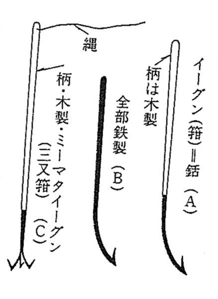
(A) igun with wooden handle
(B) all-metal igun
(C) tri-pronged mimata igun with wooden handle and rope
The Yaeyama region has indeed since long ago been home to a type of fishing called "igun fishing," carried out in this way:
When night falls, most fish sleep in holes in the coral reefs. These are illuminated with torches, and the fish are stabbed and caught with a spear (A). For larger fish that cannot be handled with the spear alone, fishers use a three-pronged gaff as well to stab the quarry. When the fish is too strong and cannot be pulled in, they throw the spear, let the rope play out, and capture the fish once it has weakened.18
The form of the peak of Uotsuri Island must have been likened to one of these spears (see the figure), stood with its point facing upward. It can be surmised from the island name that from antiquity, fishers from the Yaeyama region went fishing around the Senkaku Islands, where they used the above methods.
Chen Kan's name for the island, Diaoyu Yu (釣魚嶼, where the first two characters mean "catching fish"), and in particular the name given by the following envoy, Guo Rulin (Diao Yu, 釣嶼, "fishing island"), clearly have their roots in the Ryukyuan appellation for the island, which referred to the shape of the island itself, resembling a fishing hook, or even more strongly a fishing spear.
Having confirmed this, let us examine the reason Chen Kan included yu, the additional character for "fish," in the middle of his rendering, Diaoyu Yu (釣魚嶼). I believe this is because on Okinawa at that time, particularly on the Okinawan mainland, this island was called "Uotsurishima" (fish-catching island) or "Uoshima" (fish island). As noted above, Makino states that the island was called Yokon or Yukun on Okinawa and Igunjiima in the Yaeyama region; all of these mean "island where the fishing is good." The historian Higashionna Kanjun explains: "Early on, the Senkaku Islands were well-known as 'Yukun Kubashima,' with Yukun signifying Uoshima and Kubashima meaning Kobashima." The names Yukun and Yokon almost certainly have their roots in the dialect spoken on the Okinawan mainland: in the central and southern parts of the island fish are called iyu, while in the island's north they are yu.19
As I will illustrate later in my paper, the maps thought to be used most frequently on journeys between Naha and Fuzhou in the eighteenth and nineteenth centuries were made by Okinawans. One of these marks the island as Uotsuridai and another simply as Uotsuri, both using the characters in the Japanese order. The creators of these two maps have not been identified, but the charts themselves are works of great precision and accuracy. They were clearly put to use in actual navigation and gradually improved over long years. From these documents we can see that this island (the "Diaoyu Yu" from Chen Kan's record) had since well before the eighteenth century been called Uotsuri, Uotsurishima, or Uotsuridai in Okinawa. We can surmise that these names were the ones commonly used by Ryukyuan seafarers during that era.
Let me sum up what I have stated thus far. Well before Chen Kan's 1534 journey to the Ryukyus, the existence of these islands was known to the people of Okinawa, who had given them names. The Okinawans either referred collectively to what are now Uotsuri and Kuba Islands as "Kubashima" or called the former "Kubashima" and the latter "Tsurishima." In the Yaeyama region, today's Uotsuri Island was named "Igunjiima," meaning "fishing [or spearfishing] island," after its shape, which resembled a fishing spear. In the dialect in use on the island of Okinawa, it was called "Yukun" or "Yokon," as well as "Uoshima" (fish island) or "Uotsurishima" (fish-catching island), all of these signifying an island where the fishing is good or an island with plentiful fish. In the end, it was Uotsurishima (Uotsuri Island) that became the accepted name for the main island of the Senkakus. Chen Kan knew nothing of the sea route from Fuzhou to Naha and learned all the details of the sailing from the Ryukyu court emissary and the Ryukyuan navigators on board his ship. (Indeed, as I note above, the Chinese had no need to sail north from the island of Taiwan or the Taiwan Strait into the seas stretching from the Banjia Islands toward the Senkakus, nor any desire to do so, given the challenging natural conditions in place there.) Therefore, it is natural to view the names Chen Kan gave to the Senkaku Islands as his records approximating the Ryukyuan names taught to him by the Ryukyuans he sailed with. The Chinese claim--that Chen Kan "discovered" the islands for the first time in 1534 and gave them names in Chinese--cannot be discerned from the record of his voyage and, it must be said, is a stretch of the imagination in the light of what we know about the actual state of Chinese sailing in these seas during that era.
Let us next briefly examine some other questions relating to the islands' names that arise in the records of journeys taken by envoys following Chen Kan.
The 1561 Chongbian shi Liuqiu lu (Revised Record of the Imperial Mission to Ryukyu), the record by Guo Rulin, the next envoy to travel to the Ryukyus after Chen Kan, is also suggestive. According to this record, Guo's vessel sailed past Xiao Liuqiu (northern Taiwan) before passing Huangmao, Diao Yu, and Chi Yu in turn. There is some doubt with respect to the Senkaku Islands appearing so suddenly after the vessels leave the northern point of Taiwan, but let us say that fair winds and an ideal course made this possible. In this case, we should view this Huangmao and Diao Yu as referring to the Senkaku Islands.
The first one, Huangmao (黄茅, then pronounced something like kwau bou), was Kubashima to the Ryukyuans, while Diao Yu (釣嶼, "fishing island") was Tsurishima to them. These were, respectively, Uotsuri Island, the main Senkaku island, and Kuba Island. It appears as though these are in the opposite order from Chen Kan's "Diaoyu Yu" and "Huangmao Yu," but we can recognize them nonetheless as accurate representations of the Ryukyuan names for these islands in use then. Basically, the set of islands now called Uotsuri and Kuba were collectively "Kubashima," and when it was necessary to differentiate between them, the main island became "Kubashima" and the smaller one "Tsurishima." (Here there was also a likely vowel shift from /e/ in "Tsureshima" to /i/. This shift from /re/ to /ri/ was commonly seen in Okinawan linguistics.)20 This explains the Chinese envoys' choice of transcriptions for the names.
Guo Rulin's record is of particular note for its transmission of the Okinawan names for the islands in this era. It is also interesting for using "Diao Yu," not "Diaoyu Yu," to refer to Uotsuri Island. (Here "Diao Yu" could be interpreted as representing either "Tsurishima," whether indicating the fishing or spearfishing sense, or "Tsureshima.") Whatever the case, that Chen Kan and Guo, the following envoy, wrote about the islands with slightly different terminology, including an inverted order of passage by them, speaks eloquently to the fact that the Chinese were not the ones who discovered and named the islands in the first place. In short, the slight divergence between their descriptions arises from differences in how these two envoys heard the island names told to them. The Chinese names for the Senkaku Islands--Diaoyu Yu, Huangwei Yu, and Chiwei Yu--became fixed over time after this shaky start in the early phase of Chinese knowledge of them. We can thus confirm that the Ryukyuan names for the islands, extant for far longer, were translated into Chinese.
I next turn my attention to the final two records of the imperial envoys' journeys to the Ryukyus. First is Xu Liuqiu guo zhi lue (Additional Abridged Record of the Ryukyu Kingdom), the record of the 1808 round trip taken by Qi Kun and Fei Xizhang. According to this document, in that year, the vessel carrying the envoy Qi Kun and his party sailed as follows:
On the morning of the first day of the fifth intercalary month, we left behind the port of Wuhumen, sailed past Gantang, and headed out to sea. We sailed past Dongsha and that night went past Banjia Island [meaning 彭佳嶼, or Pengjia Yu; note the use of the Japanese-origin name 半架島 instead]. At dawn on the twelfth day we sighted Erlin Shan [二林山, likely also a Japanese-derived name] and, after traveling another two geng [approximately 60 kilometers], we saw Huaping Yu. After passing by the southern coast of this island, that night we sailed past Meihua Yu [梅花嶼, again, probably a Ryukyu name]. At dawn on the thirteenth, we saw Diaoyutai. We passed to the south of the island and at noon on the same day cleared Chiwei Yu as well. From there we sailed four geng five dian [about 150 kilometers] across the trench, where we offered prayers to the sea. On the fifteenth, at dawn we espied Gumi Shan [Kumejima Island].
The characteristics of this journey include, firstly, its course, which saw no landings on Taiwan but involved a port turn after passing the three small Banjia Islands, followed by an easterly tack taking the ship past the southern coast of Uotsuri Island and Chiwei Yu (Kumeakashima Island) and leading to Kumejima Island. This was, in short, a standard course used by Ryukyuan sailors--as I explain later, the very same as the To Bin koro zu (charts of sea routes to Fujian). Secondly, the characters appearing in the report are Banjia Island (半架島), rather than the Chinese equivalent Pengjia Yu (彭佳嶼). Furthermore, rather than Mianhua Yu (棉花嶼) the text refers to Meihua Yu (梅花嶼), another name likely to have come from the Ryukyuans. (This name appears on two Fujian route charts made by Ryukyuans, as well as the "Kaitozu" [Chart of Seas and Islands] in the 1768 Shinan kogi [Broad Overview of Navigation]. Chinese-produced written guides and charts for navigation, meanwhile, use the name Mianhua Yu.) Also of interest is the appearance of an island named Erlin Shan (二林山, again, a name that likely originated in Japanese as Nirin-zan). This name appears frequently on Ryukyuan sea charts (as above, on the two Fujian route charts and the "Kaitozu" in Shinan kogi), but it does not appear at all in sea charts and navigation guides produced by Chinese. Incidentally, it is unclear what island this name actually refers to. I will address this in detail in a later section on the Ryukyuan charts of sea routes to Fujian, but to sum up, I believe that Erlin Shan is Guishan Island, off the eastern coast of Taiwan. I speculate that Ryukyuan sailors traveling between Naha and Fuzhou saw Guishan after passing Banjia, Huaping, and Meihua, calling it Nirin-zan. Whatever the case, though, Qi Kun's journey log clearly shows that he depended wholly on the knowledge of the Ryukyuans.
Thirdly, it is worth noting that Qi Kun's ship passed to the south of Uotsuri Island. This was a course commonly chosen by Ryukyuan sailors. Vessels that approached Taiwan's northernmost point, passed Banjia, Huaping, and Meihua, and continued eastward could naturally veer to the south of the island. (See the discussion of the Ryukyuan charts of sea routes to Fujian later in this paper.) From this course, depending on the weather and the time of sunset, it is indeed possible that Huangwei Yu (Kuba Island) would not be visible. (Huangwei Yu makes no appearance in Qi Kun's record, nor in any other envoy's journey log during the Qing era.) We must note that these details on the course taken by Qi, in short, show it to have been the standard route taken by Ryukyuan sailors.
Next I examine Xu Liuqiu guo zhi lue (Additional Abridged Record of the Ryukyu Kingdom), the record published in 1882 on the journey of Zhao Xin, the final Chinese envoy to the Ryukyu Kingdom. His document is extremely important in connection with the question of island names. Zhao came to the Ryukyus in 1866 as the last of the dynastic envoys to the islands. In his record, he writes about the courses taken in that journey as well as an earlier one in 1838. The earlier journey was undertaken by Lin Hongnian, the previous envoy. (His record has been lost, but the course he took is recorded in Zhao's log.)
On the fourth day of the fifth month of 1838, the envoy's vessel left the port of Wuhumen and headed out to sea. On the afternoon of the fifth day, we saw Banjia Shan [island] to our south. In the afternoon of the sixth we sailed by Diaoyu Shan, and in the late afternoon we adjusted the course based on Kubajima. . . . Around dawn on the seventh, we took a course based on Kumeakashima. And around dawn on the eighth we did the same at Gumi Dao [Kume Island]. As for the course taken in 1866, we headed out to sea on the ninth day of the sixth month. In the late afternoon on the tenth we passed Banjia Shan, and in the evening of the eleventh we passed Diaoyu Shan. Past nightfall we passed Kubajima, and in the early afternoon on the twelfth we passed Kumeakashima. In the morning on the fifteenth we espied Gumi Shan. [My italics.]
This description of the courses set for the two final envoys' voyages is especially important for its use of the Ryukyuan names Kubajima (Kuba Island) and Kumeakashima (Kumeakashima Island), rather than the Chinese equivalents of Huangwei Yu and Chiwei Yu. (And as I note above, "Banjia Shan" is likely a name of Ryukyuan origin as well.) In short, this document indicates that during that era, the names "Kubajima" and "Kumeakashima" were firmly established in Okinawa. What is more, the official envoys sent by the Qing government of China had no qualms about using these names in an official report--a sign that China did not view the islands in question as Chinese territory or have any intention of making them part of China. As a historical record, this report is on a par with the maps and island name lists in another document from the same era--the 1889 survey report You li Riben tu jing (A Tour of Japan Through Maps)21 by Fu Yunlong, which clearly includes the Senkaku Islands in Japanese territory--in setting a vitally important precedent.
(Continued in Part 2.)
Recommended citation:Ozaki Shigeyoshi, "The Legal Status of the Senkaku Islands: Their Inclusion in Japanese Territory and the Legal Basis for This," Review of Island Studies, January 23, 2015, http://islandstudies.oprf‐info.org/research/a000 15/. Translated from "Senkaku Shoto no hoteki chii Nihon ryodo he no hennyu keii to sono hoteki kengen ni tsuite," Tosho Kenkyu Journal, Volume 3 No. 2 (April, 2014), pp. 6-27; published by the OPRF Center for Island Studies.
- Ozaki Shigeyoshi, "The Senkaku Islands and Japan's Territorial Rights." Part 1: in Review of Island Studies, June 10, 2013, /islandstudies//research/a00001/. Translated from "Senkaku Shoto to Nihon no ryoyuken," Tosho Kenkyu Journal, Vol. 1 (June 2012), pp. 8-17. Part 2: in Review of Island Studies, June 10, 2013, /islandstudies//research/a00004/. Translated from "Senkaku Shoto to Nihon no ryoyuken,"Tosho Kenkyu Journal, Vol. 2 No. 1 (October 2012), pp. 8-27. Part 3: in Review of Island Studies, February 14, 2014, /islandstudies//research/a00009/. Translated from "Senkaku Shoto to Nihon no ryoyuken," Tosho Kenkyu Journal, Vol. 2 No. 2 (April 2013), pp. 6-33. Published by the OPRF Center for Island Studies. [↩]
- In recent Ryukyu studies, the "early modern Ryukyus" represent the territory (Okinawa) as it stood from the Satsuma domain's invasion of the islands in 1609 through the disbanding of the Ryukyu state by Japan's Meiji government in 1879. See Tomiyama Kazuyuki, ed., Ryukyu, Okinawa shi no sekai (The World of Ryukyu and Okinawan History), Vol. 18 of Nihon no jidai shi (History of Japan's Eras) (Tokyo: Yoshikawa Kobunkan, 2003), pp. 48-49. [↩]
- According to L. F. L. Oppenheim, a leading international legal scholar of that era, stating a claim to territory not under control of any other state (terra nullius in terms of international law) could not be accomplished by discovery alone; according to this principle, effective occupation of the territory also had to be shown. During the nineteenth century, this became a dominant principle of international law as it was put into practice by various states. [↩]
- See Nishizato Kiko, "'Senkaku mondai' no rekishiteki zentei: Chu-Ryu-Nichi kankeishi kara kangaeru" (Historical Premises of the "Senkaku Issue": From the Perspective of the History of China-Ryukyu-Japan Relations), in Okinawa University Institute for Regional Studies, ed., Senkaku Shoto to Okinawa: Jidai ni honro sareru shima no rekishi to shizen (The Senkaku Islands and Okinawa: Island History and Nature Buffeted by the Times) (Tokyo: Fuyo Shobo, 2013), pp. 80-81. [↩]
- Kadena Sotoku, Ryukyu shi no saikosatsu (A Reconsideration of Ryukyu History) (Ginowan, Okinawa: Okinawa Aki Shobo, 1987), pp. 289-90. [↩]
- From Nihon minzokushi taikei I: Okinawa (Survey of Japanese Folklore, Vol. I: Okinawa) (Tokyo: Kadokawa Shoten, 1974), pp. 24-26. See also the foreword, pp. 5-6. [↩]
- Ozaki, "The Senkaku Islands and Japan's Territorial Rights," Part 2 (see note 1). [↩]
- See the explanation at "Senkaku Note: Senkaku Shoto mondai I" (Senkaku Note: Senkaku Islands Issues, Part I), 2.2.2, http://senkakujapan.nobody.jp/page089.html (accessed on January 7, 2015; in Japanese). [↩]
- Ibid., 1.2. See also Okaya Koji, Jinja no kigen to kodai Chosen (The Origins of Shinto Shrines and Ancient Korea) (Tokyo: Heibonsha, 2013), pp. 134-35. [↩]
- Iha Fuyu, Onarigami no shima (Islands of the Onarigami) (Tokyo: 1938, Rakuro Shoin; reprinted 1942), pp. 1, 3, and 5. The relationship between the Ryukyuan king and the Kikoe-Ogimi (see note 13) was also rooted in this onarigami belief. See Hokama Shuzen, Omoro soshi (The Omoro Storybook) (Tokyo: Iwanami Shoten, 1985), pp. 46, 187-88. [↩]
- See Hokama, Omoro soshi, pp. 26-27 and Ono Juro, Nanto kayo (Songs of the Southern Islands) (Tokyo: NHK Publishing, 1977), pp. 130-31. [↩]
- See Shin Ryukyu shi: Ko Ryukyu hen (A New History of the Ryukyus: The Ancient Ryukyus) (Naha, Okinawa: Ryukyu Shimpo, 1991), pp. 207-8, and Hokama, Omoro soshi, pp. 158, 253-59. [↩]
- The meaning of this title is "famed, great lord." It was given to the highest priestess in the kingdom, usually a younger sister of the king or the queen, who was appointed by the king to serve in the position. In addition to offering prayers for the peace of the state and bountiful harvests and lending spiritual power to the king, the Kikoe-Ogimi carried out ceremonies to pray for victory in battle. See Hokama, Omoro soshi, pp. 41-42, 46. [↩]
- See Hokama, Omoro soshi, pp. 209, 254-58. [↩]
- See ibid., pp. 253-61, and Ono, Nanto kayo, pp. 167-70, 172-83. [↩]
- See Ikemiya Masaharu, Ryukyu kogo jiten: Konko kenshu no kenkyu (Dictionary of Classical Ryukyuan: A Study of the Konko Kenshu) (Tokyo: Daiichi Shobo, 1991), particularly pp. 153, 228, and 193 for the relevant terminology. (I was pointed along this line of questioning by "Senkaku Note: Senkaku Shoto mondai I.") [↩]
- The first quote is from Makino Kiyoshi, "Senkaku Retto (Igun Kubajima) shoshi" (A Short History of the Senkaku Islands [Igun Kubajima]), in Kikan Okinawa (Okinawa Quarterly) 56 (1971), p. 65. The second is from Makino, Shin Yaeyama rekishi (A New History of Yaeyama) (self-published, 1972), p. 32. [↩]
- Kishaba Eijun, Yaeyama minzokushi: Jokan, minzokutan (Folklore of Yaeyama: Vol. 1, Folk Stories) (Naha, Okinawa: Okinawa Times, 1977), pp. 69-70. The attached figure is based on one in this work. [↩]
- Higashionna Kanjun, Nanto fudoki (Culture and History of the Southern Islands) (Naha, Okinawa: Japanese Society for Okinawan Studies and Okinawa Zaidan, 1950), p. 455. See also Nakamoto Masachie, Zusetsu Ryukyugo jiten (Illustrated Dictionary of Ryukyuan) (Tokyo: Rikitomi Shobo and Kinkeisha, 1981), pp. 154-55. [↩]
- See "Senkaku Note," 2.2.4. [↩]
- I introduced this work in greater detail in Ozaki Shigeyoshi, "The Senkaku Islands and Japan's Territorial Rights (Part 3)," Review of Island Studies, February 14, 2014, /islandstudies//research/a00009/. Translated from "Senkaku Shoto to Nihon no ryoyuken," Tosho Kenkyu Journal, Vol. 2 No. 2 (April 2013), pp. 6-33; published by the OPRF Center for Island Studies. [↩]
Professor emeritus at the University of Tsukuba. Specializes in international law. Born in 1936. Graduated from the University of Tokyo, where he majored in law. Received his doctorate from the Division of Law and Politics, University of Tokyo Graduate School. Worked in the Research and Legislative Reference Bureau of the National Diet Library. Has served as a professor in the Faculty of Law, Niigata University; the Institute of Social Sciences, University of Tsukuba; and the Faculty of International Political Science and Economics, Nishogakusha University. The following are his main works on the Senkaku territorial issue: 1. “Senkaku Shoto no kizoku ni tsuite” (Territorial Sovereignty over the Senkaku Islands), pts. 1, 2, 3-1, and 3-2, Reference nos. 259 and 261–63 (1972). 2. “Senkaku Shoto no kokusaihojo no chii: Shu to shite sono rekishiteki sokumen ni tsuite” (The Status of the Senkaku Islands in International Law: Concerning Mainly Their Historical Aspect), Tsukuba Hosei 18, no. 1 (1995). 3. “Territorial Issues on the East China Sea: A Japanese Position,” Journal of East Asia and International Law 3, no. 1 (2010). 4. “Senkaku Shoto to Nihon no ryoyuken,” published in three parts in Tosho Kenkyu Journal, Vol. 1 (June 2012), Vol. 2 No. 1 (October 2012), and Vol. 2 No. 2 (April 2013); published by the OPRF Center for Island Studies. Translated as “The Senkaku Islands and Japan’s Territorial Rights,” Review of Island Studies, June 10, 2013, http://islandstudies.oprf-info.org/research/a00001/.
Related Research

U.S. Recognition of Japanese Sovereignty Over the Senkaku Islands
Raul(Pete)Pedrozo (Sep 15, 2022)
Protest and Acquiescence in Territorial Acquisition: In relation to the Senkaku Islands
MIYOSHI Masahiro (May 01, 2018)
International Law and Japan's Territorial Disputes
Raul (Pete) Pedrozo (Feb 06, 2018)
The Senkaku Islands as Viewed through Chinese Law
SAKAMOTO Shigeki (Sep 12, 2016)
Related Readings
TAKAHASHI Noritsugu (Sep 15, 2022)
TAKAI Susumu (Sep 15, 2022)
CHIBA akira (Sep 27, 2021)
Notes on David Helliwell's "The Clashing Rocks"
ISHIWI Nozomu (Sep 12, 2016)