 RSS
RSS1862
The Shogunate dispatched the ship “Kanrin-maru” to Ogasawara to engage in exploratory surveys and measurements. The leader in the ship informed the islanders that the islands were part of Japanese territory and that all settlers would be protected, and gained the consent of the settlers.
Mizuno explained to the islanders that the islands were part of Japanese territory and that the purpose of the mission was to develop the islands. He emphasized that no islanders would be evicted and called on them to live in harmony with settlers from the Japanese mainland, explaining the Ogasawara Islands control regulations and harbor regulations. The islanders agreed to abide by these regulations (Ref. 1, 4)
Upon receiving Mizuno’s report, the Shogunate decided the development and settlement in Ogasawara, and began recruiting applicants of settlers at Hachijojima. Due to the Shogunate’s policy that the settlers should be married couples in principle, a total of 30 people, consisting of 15 men and 15 women, have decided to emigrate, who arrived on Chichijima in August 1862, together with eight carpenters and blacksmiths. (Ref. 5)
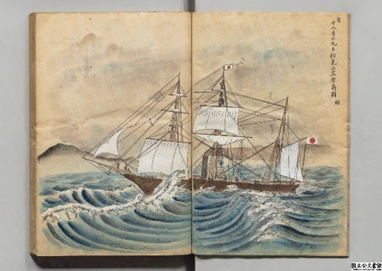
Map of the first view of the Ogasawara Islands, December 19, 1861. (Ref. 6)
(National Archives of Japan)
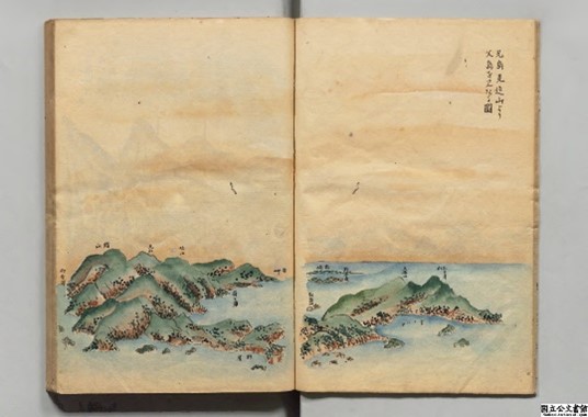
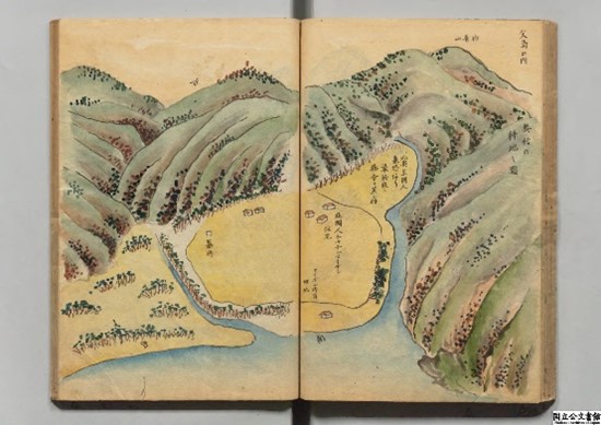
Map looking over to Chichijima from Mt. Mikaeri on Anijima (Ref. 6)
(National Archives of Japan)
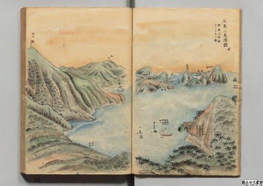
Map of Futami harbor, Chichijima
Includes reference to the “U.S. coal storage depot”, which is the land that Perry had purchased.
(National Archives of Japan)
Map of Omura, Chichijima (Ref. 6)
(National Archives of Japan)
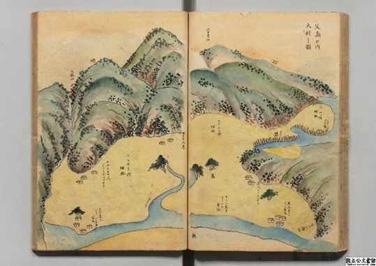
Map of arable land in Okumura, Chichijima (Ref. 6)
(National Archives of Japan)
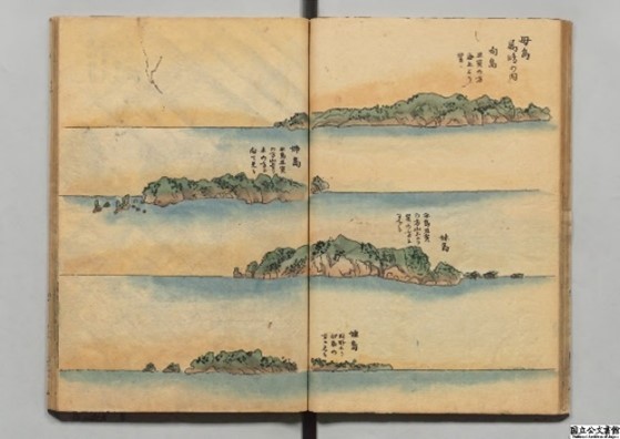
Mukojima, Anejima, Imotojima, and Meijima of Hahajima islands (Ref. 7)
(National Archives of Japan)
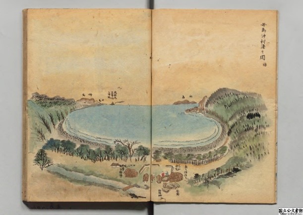
Map of Okimura harbor, Hahajima (Ref. 7)
(National Archives of Japan)
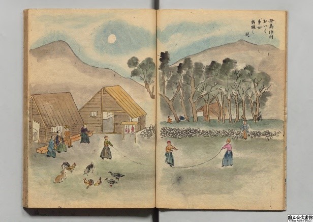
People of Okimura, Hahajima (Ref.7)
(National Archives of Japan)

Ref.1:“The matter concerning the development and revitalization of the Ogasawara Islands 2,” Zoku Tsushin-zenran (Continued Series of Complete List of Diplomatic Notes and Correspondence), Compilation by category, Miscellaneous 1289
(Repository: Diplomatic Archives of the Ministry of Foreign Affairs of Japan)
Ref.2:“A real landscape of Ogasawara, Section of Chichijima (Drawings of Chichijima & Hahajima including fishes, shellfishes and others, in the appendix to ‘The matter concerning the development and revitalization of the Ogasawara Islands’),” Zoku Tsushin-zenran (Continued Series of Complete List of Diplomatic Notes and Correspondence), Compilation by category, Miscellaneous 1299
(Repository: Diplomatic Archives of the Ministry of Foreign Affairs of Japan)
Ref.3:“A real landscape of Ogasawara, Section of Hahajima (Drawings of Chichijima & Hahajima including fishes, shellfishes and others, in the appendix to ‘The matter concerning the development and revitalization of the Ogasawara Islands’),” Zoku Tsushin-zenran (Continued Series of Complete List of Diplomatic Notes and Correspondence), Compilation by category, Miscellaneous 1299
(Repository: Diplomatic Archives of the Ministry of Foreign Affairs of Japan)
Ref.4:“The matter concerning the development and revitalization of the Ogasawara Islands 3,” Zoku Tsushin-zenran (Continued Series of Complete List of Diplomatic Notes and Correspondence), Compilation by category, Miscellaneous 1290
(Repository: Diplomatic Archives of the Ministry of Foreign Affairs of Japan, 443-44)
Ref.5:“The matter concerning the development and revitalization of the Ogasawara Islands 9,” Zoku Tsushin-zenran (Continued Series of Complete List of Diplomatic Notes and Correspondence), Compilation by category, Miscellaneous 1296
(Repository: Diplomatic Archives of the Ministry of Foreign Affairs of Japan, 743-751)
Ref.6:“A real landscape of Ogasawara, Section of Chichijima” Historical records of the Ogasawara Islands, vol. 19
Ref.7:“A real landscape of Ogasawara, Section of Hahajima,” Historical records of the Ogasawara Islands, vol. 20
Ref.1:Tanabe Taichi, “A patrol visit to the Ogasawara Islands,” Bakumatsu Gaiko Dan (Tales of foreign relations at the end of the Shogunate) (Publisher: Fuzambo, 1898), pp. 193-196
Ref. 2:R.D. Eldridge, Iwo Jima and the Bonin Islands in U.S.-Japan Relations, (in Japanese translation), Kagoshima: Nanpo Shinsha, 2008, pp. 42-44.
Ref. 3:Tanaka Hiroyuki, Bakumatsu no Ogasawara (Ogasawara at the End of the Edo Period), Chuo Koronsha, 1997 (Chuko Shinsho), pp. 136-187.
Related Research

No article
Related Readings
No article
Info Library
Info Library
Japan's Island Territories
Senkaku Islands Facts & Figures
Takeshima Facts & Figures
Northern Territories Facts & Figures