 RSS
RSSThe Functions and Work of the Commission on the Limits of the Continental Shelf
How It Responds to Disputed Island Claims Among Coastal States
Sep 19, 2013 PDF Download
1. Introduction
Article 76 of UNCLOS, the UN Convention on the Law of the Sea, stipulates that coastal states may establish the outer limits of their continental shelf beyond 200 nautical miles in case there is topographical or geological continuity, provided the Commission on the Limits of the Continental Shelf (CLCS) issues a recommendation approving the submission. Since a delineation of the outer limits of the continental shelf beyond 200 nautical miles may be submitted using an offshore island as the baseline, islands have an important meaning for countries seeking an extension. And they are particularly crucial when an extension results in an overlap among states with opposite or adjacent coasts owing to disputed island claims or divergent views of territorial boundaries. In such cases, the CLCS, in accordance with related clauses, withholds its review of the submitted materials.
This paper reviews the functions of the CLCS, as stipulated by UNCLOS and other related materials, and examines how it has dealt with various cases where objections have been raised over the inclusion of certain islands in another state's submission of claims to an extended continental shelf.
2. The Functions of the CLCS
A. UNCLOS Provisions
The continental shelf1 of a coastal state, according to Article 76, Paragraph 1, of UNCLOS, comprises the seabed and subsoil of the submarine areas that extend beyond its territorial sea throughout the natural prolongation of its land territory to the outer edge of the continental margin, or to a distance of 200 nautical miles from the baselines from which the breadth of the territorial sea is measured where the outer edge of the continental margin does not extend up to that distance. A coastal state may also establish the outer limits of its continental shelf beyond 200 nautical miles based on the recommendations of the CLCS after submitting the particulars of such limits, along with supporting scientific and technical data, to the Commission (Paragraph 8, Article 76). Coastal states, moreover, exercises sovereign rights over the continental shelf for the purpose of exploring it and exploiting its natural resources (Paragraph 1, Article 77).
The functions of the CLCS, as stipulated in Paragraph 1, Article 3, of UNCLOS Annex II, are to consider and make recommendations on the data and other material submitted by coastal states concerning the outer limits of the continental shelf in areas where those limits extend beyond 200 nautical miles and to provide scientific and technical advice, if requested by the coastal state.
At the same time, Article 76, Paragraph 10, and Article 9 of Annex II maintain that the actions of the Commission are without prejudice to the question of delimitation of the continental shelf between states with opposite or adjacent coasts. This is a corollary of the provisions in Article 83, which, in the interest of reaching an equitable resolution, stipulates that the delimitation of the continental shelf between states with opposite or adjacent coasts shall be effected by agreement on the basis of international law. Avoiding impacting on the delimitation of national boundaries is a "fundamental duty"2 of the CLCS, and it has established detailed procedural regulations, as outlined below, to ensure adherence to this duty.
B. Rules of Procedure
After CLCS was established in 1997,3 its Rules of Procedure4 were successively drawn up covering a broad array of issues, including the holding of sessions, members of the Commission, conduct of business, and examination of submissions by coastal states.5
In case there is a dispute in the delimitation of the continental shelf between opposite or adjacent states or in other cases of unresolved land or maritime disputes, rule 46 provides that submissions may be made and will be considered in accordance with Annex I. The annex contains detailed rules on how the CLCS should handle any submissions in case of such a dispute.
In case there is a dispute in the delimitation of the continental shelf between opposite or adjacent States, or in other cases of unresolved land or maritime disputes, Paragraph 2 of the annex stipulates that the Commission be (a) informed of such disputes by the coastal states making the submission and (b) assured by the coastal states making the submission to the extent possible that the submission will not prejudice matters relating to the delimitation of boundaries between states.
The following paragraph notes that a "partial submission" may be made by a coastal state for a portion of its continental shelf in order not to prejudice questions relating to the delimitation of boundaries between states.
Paragraph 4 cites that joint or separate submissions may be made by two or more coastal States by agreement without regard to the delimitation of boundaries between those States or with an indication, by means of geodetic coordinates, of the extent to which a submission is without prejudice to the matters relating to the delimitation of boundaries with other state parties.
In cases where a land or maritime dispute exists, according to Paragraph 5 (a), the Commission will not consider a submission made by any of the states concerned in the dispute, but it may consider a submission when prior consent is given by all states that are parties to such a dispute.
C. The Work of the CLCS
As of August 30, 2012, 61 submissions for an extension of the continental shelf have been made to the CLCS. Recommendations have been adopted for 18 submissions, 6 are under consideration, and 37 are waiting to be considered.6
In addition, 45 cases of "preliminary information" have been submitted. These represent an attempt, based on a decision at the June 2008 meeting of state parties to UNCLOS, to accommodate the needs mostly of developing countries that lack the requisite expertise and resources to meet the May 12, 2009, deadline for full submissions.7 By at least submitting preliminary information indicative of the outer limits of the continental shelf beyond 200 nautical miles by May 12, 2009, they were able to ensure consideration of their full submission by the CLCS even if the information was not complete.
Countries seeking to set the outer limits of the continental shelf beyond 200 nautical miles must submit to the CLCS an executive summary, main body (containing scientific analysis), and supporting technical data, as prescribed by Annex III of the Rules of Procedure. Of these documents, only the executive summary is made public on the CLCS website.
Because CLCS meetings are, as a rule, held in private,8 there is no way of ascertaining how the submissions were considered. But the statements issued by the CLCS chair after each session provides an overview of the items considered during the session (although reference is made only to procedural matters, and no mention is made of the substance of the deliberations). Summaries of the recommendations made by the CLCS as a result of the discussions, though, are available on the CLCS website.9
3. Approaches to Submission: Viewed in Terms of International Relations
As shown above, the CLCS has drawn up detailed rules, as contained in Annex I of the Rules of Procedures, to avoid prejudicing matters relating to the delimitation of boundaries between states. Coastal states make various submissions in accordance with these rules. To prevent states with opposite or adjacent coasts from voicing objections and thus interrupting the consideration process, many coastal states conduct negotiations with such states prior to making a submission. Whether or not such negotiations prove fruitful hinges largely on the mutual interests of the relevant states and their historical relations. Coalter Lathrop has analyzed the submissions made thus far and has classified them into five approaches: "(1) settle delimitations prior to making a submission; (2) make a partial submission that avoids unresolved disputes; (3) make a joint submission among several States, thereby internalizing any unresolved disputes within the group of submitting States; (4) make a separate submission after consultation with neighboring States in order to avoid objection; and (5) make a separate submission without assurances of no objection."10 Given the actual complexity of the circumstances involved, some submissions fall under multiple classifications.
Below is a discussion of submissions involving unresolved island disputes in the South China Sea and a submission by Japan concerning Okinotorishima Island.
A. Submissions by Coastal States Bordering the South China Sea and Preliminary Information
A number of coastal states make territorial claims to the Spratly and Paracel Islands in the South China Sea, and there is lingering tension in the region. Some have pointed out that the limits of each state's territorial claims have become clearer following the establishment of the May 2009 deadline for submission to the CLCS.11 Below is an examination of the submissions made by coastal states bordering the South China Sea for the delimitation of the continental shelf beyond 200 nautical miles, along with preliminary information.
(1) Joint Submission by Malaysia and Vietnam
Malaysia and Vietnam made a joint submission to the CLCS for the southern part of the South China Sea on May 6, 2009. It is an area where the continental shelf of the two coastal states extends beyond 200 nautical miles from the respective baselines of the two coastal states and overlaps (see the map on p. 5 of the document at the CLCS Website). The executive summary of the joint submission notes that there are unresolved disputes in the defined area and that the joint submission will not prejudice matters relating to the delimitation of boundaries between states with opposite or adjacent coasts.
In its note verbale dated May 7, 2009, regarding the joint submission, China contended that it held indisputable sovereignty over the islands in the South China Sea. Saying that the submission seriously infringed on China's sovereignty, sovereign rights, and jurisdiction, China requested the Commission not to consider the joint submission. Vietnam responded with a note verbale stating that the Spratly and Paracel archipelagoes are parts of Vietnam's territory and that China's claim has no legal, historical, or factual basis. Malaysia, meanwhile, asserted that the joint submission was made without prejudice to the Convention and the CLCS Rules of Procedure.
In a note verbale dated August 4, 2009, the Philippines also requested the Commission to refrain from considering the joint submission, noting that it lays claim to areas that overlap with Philippine claims and also pointing to the controversy arising from the territorial claims on some of the islands in the defined area, including North Borneo. Both Vietnam and Malaysia issued comments regarding the respective notes verbales.
Indonesia, on July 8, 2010, also submitted a note verbale to the effect that the sovereignty claims made in China's communication refer to features in the South China Sea that are uninhabited rocks, reefs, or atolls isolated from the mainland and do not deserve an exclusive economic zone or continental shelf. This, the communication noted, contradicts China's own position, as stated at meetings of the International Seabed Authority and of state parties to the Convention,12 and thus clearly lacks international legal basis.
Following a presentation by Malaysia and Vietnam, taking into account the above notes verbales, a decision was made during the twenty-fourth session of the CLCS, held in August and September 2009, to defer further consideration of the joint submission and the notes verbales until such time as the submission is next in line for consideration as queued in the order in which it was received.13 As of August 30, 2012, the submission was fifth in line and has yet to be considered.
(2) Partial Submission by Vietnam
On May 7, 2009, a day after making the above joint submission, Vietnam unilaterally made a partial submission in respect of Vietnam's extended continental shelf in the north area. In its note verbale of May 7, 2009, China requested that the CLCS not consider the submission, claiming that it seriously infringed on China's sovereignty, sovereign rights, and jurisdiction over islands in the South China Sea. In response, Vietnam issued a note verbale containing arguments similar to those described in (1) above.
The Philippines, too, requested that the CLCS refrain from considering the unilateral submission, as it lays claims on disputed areas that overlap with claims by the Philippines. In response, Vietnam countered that its submission was legitimate. The Philippines also expressed its views regarding the note verbale submitted by China, noting that the Philippines has sovereignty and jurisdiction over the Kalayaan island group.
Following a presentation by Vietnam, taking into account these notes verbales, a decision was made during the twenty-fourth session of the CLCS, held in August and September 2009, to defer further consideration of the submission and the notes verbales until such time as the submission is next in line for consideration as queued in the order in which it was received.14 As of August 30, 2012, the submission was fifth in line and has yet to be considered.
(3) Partial Submission by the Philippines
On April 8, 2009, the Philippines made a partial submission concerning not the South China Sea but an area called the Benham Rise region east of Luzon. The executive summary notes that the region is not subject to any maritime boundary disputes, claims, or controversies and that the Philippines reserves the right to make submissions for other areas of the continental shelf beyond 200 nautical miles at a future time. No comments on this submission have yet been submitted by other states. The CLCS subsequently considered the submission, and a recommendation was adopted on April 12, 2012, during its twenty-ninth session.15 Inasmuch as the submission was a partial one relating only to the Benham Rise region, avoiding the issue of the Kalayaan island group over which sovereignty claims overlap with China, the Philippines succeeded in removing any roadblocks to a consideration (an example of the second approach under Lathrop's classification, noted above).
(4) What China's Preliminary Information Portends
While China has not made a submission concerning an extension in the South China Sea, in its preliminary information of May 11, 2009,16 it stated that it reserves the right to make submissions on the outer limits of the continental shelf that extends beyond 200 nautical miles in the East China Sea and in other sea areas (emphasis added). [See endnote.] In view of the geographical conditions along China's coastline, the wording can be construed as presaging another submission concerning the South China Sea.17
(5) Brunei's Preliminary Information
On May 12, 2009, Brunei, located on the northwestern coast of the island of Borneo, provided preliminary information on the outer limits of its continental shelf beyond 200 nautical miles from its north-facing coastline, indicating that it plans to make a full submission to the CLCS at a later date. The area beyond 200 nautical miles will likely overlap with the area defined in the joint submission by Malaysia and Vietnam, described in (1) above.18
(6) Summary
Of the five approaches delineated by Lathrop, the joint submission by Malaysia and Vietnam falls into category three, while the unilateral submission by Vietnam adopts the fifth approach. In both cases, conflicting views have been expressed by other states concerning territorial claims to the Spratly and Paracel Islands, resulting in a "dispute" between states with opposite or adjacent coasts, as defined in rule 46 of the Rules of Procedure. Unless such disputes are resolved first, the CLCS will not consider any submission made by a state that is a party to such a dispute. Given the historical background to the territorial disputes in the South China Sea and China's recent maritime excursions, the situation is unlikely to be resolved any time soon. Should China, the Philippines, and Brunei henceforth make submissions for extensions to their continental shelves, further overlaps are likely in the claims of these coastal states.
There have been many other submissions to extend the outer limits of the continental shelf by states with unresolved territorial disputes or delimitation of boundaries. Examples include the submission by Myanmar (concerning which Bangladesh submitted a note verbale indicating that it has a "dispute," as the delimitation of boundaries with that state is unresolved)19 and the respective submissions by the United Kingdom, Ireland, and Denmark over the Hatton-Rockall area.20
B. Submission by Japan
(1) Japan's Submission and the Reaction of Other States
Japan made a submission on November 12, 2008, to establish the outer limits of its continental shelf beyond 200 nautical miles in seven regions: the Southern Kyushu-Palau Ridge (KPR) region, the Minamiioto Island (MIT) region, the Minamitorishima Island (MTS) region, the Mogi Seamount (MGS) region, the Ogasawara Plateau (OGP) region, the Southern Oki-Daito Ridge (ODR) region, and the Shikoku Basin (SKB) region.21
Four states have submitted notes verbales in response to Japan's submission, and they can be classified into two types: (a) the first are from states with opposite coasts whose continental shelves may potentially overlap with those of Japan (United States and Palau) and (b) the second are from states with neither opposite nor adjacent coasts in the regions under Japan's submission (China and South Korea).
With regard to (a), it should be noted that Japan's executive summary makes explicit reference to a potential overlap with these states. Specifically, it says that potential overlap exists with the United States over the continental shelf in the areas from Hahajima Island and Minamitorishima Island (OGP and MTS) and from Minamiioto Island (MIT),22 as well as with Palau over the continental shelf in the area from Okinotorishima Island (KPR).23 Regarding these potential overlaps, the executive summary asserts that the United States and Palau have indicated that they have no objections to the CLCS considering the submission, as the areas are without prejudice to the question of the delimitation of the continental shelf beyond 200 nautical miles.24 This is corroborated in the notes verbales submitted by the United States and Palau indicating they have no objections to the CLCS considering and making recommendations on the submission.
With regard to (b), the notes verbales from China (dated February 6, 2009) and South Korea (dated February 27, 2009) contend that Okinotorishima Island is a "rock," as defined by Article 121, Paragraph 3, of UNCLOS,25 and is not entitled to a continental shelf. They request that the CLCS set aside portions relating to Okinotorishima Island, since its consideration does not fall within the CLCS mandate.26
(2) Consideration by the Subcommission
A presentation on the content of Japan's submission was made by the Japanese delegation at the twenty-third session of the CLCS (March-April 2009). While a decision was made to establish a subcommission to consider the submission, it would not be established until one of the four existing subcommissions had submitted its draft recommendations to the CLCS plenary. Regarding the comments in the notes verbales by China and South Korea, the CLCS acknowledged that it has no role on matters relating to the legal interpretation of Article 121 of UNCLOS. It did decide, though, that it would revert to the matter when it was ready to proceed with the establishment of the subcommission27 and taking into account any further developments that might occur during the intervening period.
A subcommission to examine Japan's submission was established at the twenty-fourth session (August-September 2009), as one existing subcommission had completed its consideration.28 The CLCS established a working group to discuss the notes verbales from China and South Korea, as a result of which it decided to instruct the subcommission to proceed with the consideration of the full submission of Japan, as the consideration of submissions by the CLCS concerned issues related only to UNCLOS Article 76 and Annex II and was without prejudice to the interpretation or application of other parts of UNCLOS. At the same time, the CLCS decided that it will not take action on the part of the draft recommendations prepared by the subcommission in relation to the area referred to in the notes verbales by China and South Korea until the plenary of the CLCS decides to do so.29
The subcommission considered the submission over three years between the twenty-fourth and twenty-eighth sessions (August-September 2011), including at meetings held during the sessions, and issued its draft recommendations. The CLCS decided, however, to defer further consideration of the draft recommendations to the twenty-ninth session in order to provide its members with sufficient time to consider the submission and the draft recommendations.30
(3) Adoption of Recommendations
The draft recommendations were again considered at the twenty-ninth session (March-April 2012). First, the subcommission's draft recommendations on the SKB region were amended.31 Addressing the KPR region, in accordance with the decision taken at the twenty-fourth session, the CLCS proceeded to a formal vote on whether it should take action.
To a question as to whether this was a matter of substance or of procedure, the chairperson ruled that it was one of substance, requiring a two-thirds majority.32 The CLCS then voted on whether or to take action on the KPR region. The proposal did not receive a two-thirds majority of votes: Out of 16 members, 5 were in favor, 8 were against, and 3 abstained. The CLCS considered that it would not be in a position to take action on the KPR recommendations until such time as the matters referred to in the communications by Japan, China, and South Korea had been resolved. As a result, on April 19, the CLCS adopted by consensus the recommendations of the CLCS in regard to six of the seven regions in the submission made by Japan.33
(4) The Influence of Other States' Comments on the Recommendations
As described in (1) above, the reaction to Japan's submission can be classified into two types. There was potential for overlap with the United States and Palau had they, too, along with Japan, made a submission on the outer limits of the continental shelf beyond 200 nautical miles. This would have necessitated a delimitation of boundaries. In this sense, the United States and Palau are states with opposite coasts, as defined in UNCLOS Article 76, Paragraph 10. The United States and Palau confirmed that the action of the CLCS would not prejudice the delimitation of their maritime boundaries with Japan and also explicitly stated they would not object to the consideration of Japan's submission. What is particularly important here is that Palau--the only state with which the issue of maritime delimitation could have emerged over the KPR region with its base point at Okinotorishima Island--reiterated that it had no objections to Japan's 2008 submission. This confirmed that a recommendation by the CLCS would not prejudice matters relating to the delimitation of boundaries or unresolved land or maritime disputes between them, as stipulated in UNCLOS Article 76, Paragraph 10, and rule 46 and Annex I of the Rules of Procedure. The CLCS would thus have been justified in disregarding Chinese and South Korean objections and adopting a recommendation on KPR.34
The fact that the CLCS failed to take action on the subcommission's draft KPR recommendations was likely due to its judgment that adopting them could prejudice other unresolved maritime delimitation disputes involving Japan, China, and South Korea. The CLCS seemed to think that the difference of interpretation of Article 121 among Japan, China and South Korea could prejudice matters relating to the delimitation of boundaries or unresolved land or maritime disputes mentioned above. One must, of course, take note of the fact that CLCS itself was sharply divided over this issue,35 but the decision not to adopt the recommendations involving Okinotorishima Island--over which Japan does not have delimitation issues with China and South Korea--could be based on concern with not prejudicing application of Article 121, paragraph 3.36 It therefore could expand the scope prescribed in UNCLOS of the matters relating to delimitation of boundaries between states that the CLCS should not prejudice.
(5) Reaction to the Recommendations
How did Japan and other states react to the recommendations, received by Japan on April 27, 2012? The Japanese Ministry of Foreign Affairs released a statement via its press secretary the following day, noting that while the CLCS recommendations were still being studied closely, they recognized extensions for six of the seven regions submitted--including the Shikoku Basin (SKB) region whose base point is Okinotorishima Island--and can thus be considered an important step toward expanding Japan's oceanic interests.37
Responding to a question during an April 28, 2012, press conference at the Chinese Ministry of Foreign Affairs, spokesperson Liu Weimin noted that while he was unable to comment as the results of Japan's submission have not yet been made public, he stated that China's position on the Okinotorishima Island has consistently been that it should not have a continental shelf.38 During a May 16 press conference, Chinese Ministry of Foreign Affairs spokesperson Hong Lei stated that the extension of the Shikoku Basin recognized by the CLCS was irrelevant to the Okinotorishima Island.39
A summary of the recommendations was posted on the CLCS website in early June.40 Spokesperson Liu Weimin, during a June 8 press conference, said that China has noted the summary of the recommendations released by the CLCS and also that it has noted the CLCS did not make any recommendation on Japan's claim of the KPR region based on the Okinotori Island.41 A Japanese cabinet decision of June 12, meanwhile, adopted a statement welcoming the CLCS recommendations that recognized extensions for significant portions of the SKB region, which was partially based on Okinotorishima Island, and indicating the government would continue its efforts for an early recognition of the KPR region.42
(6) Summary
The decision on the KPR region during the twenty-ninth session of the CLCS is noteworthy as a case in which a recommendation was withheld owing to objections raised by states uninvolved in the delimitation of boundaries in the area under question. With the exception of the comments regarding the suspension of territorial rights under the Antarctic Treaty,43 the only other example of a comment from a state not involved in the delimitation of boundaries was that made by the United States concerning a submission by Brazil. The United States pointed out that there were some differences between the data included in Brazil's executive summary and those derived from publicly available sources and also that the Vitória-Trindade feature, referred to as a "ridge" in the Brazilian executive summary, was now called a "seamount chain" by various scientific organizations. The CLCS responded by noting that it considers only communications from states with opposite or adjacent coasts that have unresolved land or maritime disputes and decided to disregard the US comment.44 This response is at odds with that taken by the CLCS with regard to the submission by Japan.
The views of the Japanese and Chinese governments conflict on the question of whether the CLCS considered the SKB region as one based on Okinotorishima Island. A fuller examination of the summary of the CLCS recommendations is required on this matter, but here we would make just two points. The first is that the note verbale submitted by China in 2009 refers to the SKB region as one in which Okinotorishima Island is used as a base point.45 And the second is that the reference to SKB in Paragraph 158 of the summary of the recommendations includes the land territories of the Kyushu-Palau Ridge as base points for the measurement of the submerged prolongation of the landmass of Japan and explicitly enumerates, among Japan's land territories, Okinotorishima Island on the Kyushu-Palau Ridge. Paragraph 161 further notes that the CLCS recognizes the entitlement of Japan to establish continental shelf beyond its 200 nautical mile limits in the SKB region.46
4. Conclusion
The function of the CLCS is to consider the scientific and technical data submitted by coastal states seeking to establish the outer limits of their continental shelf beyond 200 nautical miles and to make recommendations. Therefore, in order not to prejudice the matters of delimitation of boundaries, the CLCS examines the comments of both the submitting and other states and decides whether or not to consider the submission. As described above, the CLCS chose to defer further consideration of the submissions by coastal states bordering the South China Sea when objections were raised over the territorial claims of islands included in the submissions. And in the case of Japan's submission, it deferred making recommendations on specific areas of the sea, although it did consider the case and took note of the comments made by states uninvolved in the delimitation of boundaries. In the light of the CLCS's practices to date, such a decision appears rather unusual. In any event, it is worth following closely how the CLCS will handle the many submissions that are now in line awaiting consideration.
Figure 1: The extended continental shelf recognized in the recommendations to the submission made by Japan
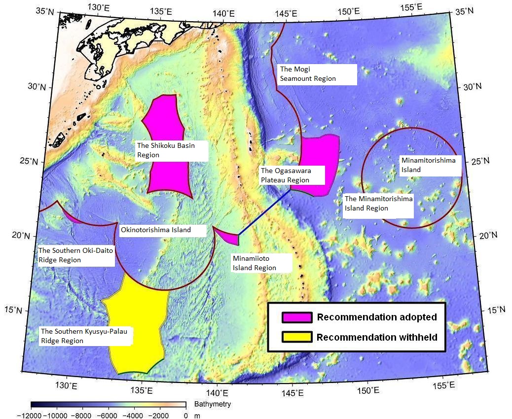
Source: Based on the Japanese handout (Document 4) at the Ninth Meeting of the Headquarters for Ocean Policy (May 25, 2012),
http://www.kantei.go.jp/jp/singi/kaiyou/dai9/siryou4.pdf.
Endnote: After this paper was completed, a media report (Yomiuri Shimbun, September 17, 2012, morning edition, p. 2) stated that China had announced it would make a submission to establish the outer limits of its continental shelf in the East China Sea. The submission was made on December 14 and is on the CLCS website at http://www.un.org/Depts/los/clcs_new/submissions_files/submission_chn_63_2012.htm.
Recommended citation: Iuchi Yumiko, Usui Asano, "The Functions and Work of the Commission on the Limits of the Continental Shelf," Review of Island Studies, September 19, 2013, /islandstudies//readings/b00005/. Translated from "Tairikudana Iinkai no ninmu to jikko," Tosho Kenkyu Journal, Vol. 2 No. 1 (October 2012), pp. 100-117; published by the OPRF Center for Island Studies.
- "Continental shelf" has two meanings, one topographical and the other legal. In this paper, the term will be used only in the latter sense, that is, as stipulated in UNCLOS. Refer to the OPRF's website (http://www.sof.or.jp/tairikudana/) for a detailed explanation of the continental shelf and the CLCS (in Japanese only). Unless otherwise noted, all websites referred to in footnotes below were last accessed on August 30, 2012. [↩]
- B. Kwiatkowska, "Submissions to the UN CLCS in Cases of Disputed and Undisputed Maritime Boundary Delimitations or Other Unresolved Land Disputes of Developing States" (2012), p. 7. Available at http://www.uu.nl/nilos/onlinepapers. [↩]
- After UNCLOS came into force in 1996, the first election for members of the Commission was held during the meeting of the state parties in 1997, at which 21 members were elected. Article 2, Paragraph 1, of Annex II stipulates that members are to be experts in the field of geology, geophysics or hydrography. Elections were subsequently held in 2002, 2007, and 2012. Current members are those who were elected or reelected in 2012. [↩]
- The Rules of Procedure have been amended on repeated occasions, and the latest version is contained in document CLCS/40/Rev. 1. [↩]
- Submissions are examined by a subcommission comprising seven Commission members, who review the scientific and technical data (the submitting state may participate in relevant subcommission proceedings), prepare a draft recommendation, and refer the draft to the full Commission. The draft is adopted after the Commission considers it and makes any necessary modifications. These procedures are outlined in Rule 42 and the Annex III of the Rules of Procedure. [↩]
- All submissions by coastal states, notes verbales by other states regarding the submissions, and other CLCS-related documents can be accessed at the CLCS website (http://www.un.org/Depts/los/clcs_new/clcs_home.htm). In the interest of saving space, therefore, the URLs of individual pages are not given here. For information on the thirtieth session of the CLCS, refer to the UN Department of Public Information press release SEA/1982, dated August 31, 2012. [↩]
- Article 4 of Annex II to UNCLOS specifies that coastal states must submit the particulars of its intentions to establish the outer limits of its continental shelf beyond 200 nautical miles within 10 years of the entry into force of UNCLOS for that state. Given the difficulty of collecting technical data and the time required to prepare a submission, though, an agreement was reached at the meeting of the state parties in 2001 to set May 13, 1999 (when the Scientific and Technical Guidelines of the CLCS were adopted), as the commencement of the 10-year period for making a submission, including for countries where UNCLOS entered into force before that date (SPLOS/183). The 10-year deadline still applies to countries such as Canada and Denmark, where UNCLOS entered into force after May 13, 1999. [↩]
- CLCS/40/Rev. 1 (Rules of Procedure), rule 23. [↩]
- CLCS/40/Rev. 1 (Rules of Procedure), Annex III, Article 11, Paragraph 3. [↩]
- C. G. Lathrop, "Continental Shelf Delimitation Beyond 200 Nautical Miles: Approaches Taken by Coastal States Before the Commission on the Limits of the Continental Shelf" International Maritime Boundaries (D.A. Colson & R.W. Smith eds., 2011), p. 4147. Available at http://scholarship.law.duke.edu/faculty_scholarship/2544. [↩]
- R. Beckman and T. Davenport, "CLCS Submissions and Claims in the South China Sea," presentation made at the Second International Workshop on "The South China Sea: Cooperation for Regional Security and Development," held on November 10-12, 2010, Ho Chi Minh City, Vietnam, available at http://nghiencuubiendong.vn/en/conferences-and-seminars-/second-international-workshop. [↩]
- During a meeting of the UNCLOS state parties held in June 2009, China contended that there were cases of an isolated rock in the ocean being used as a base point to make illegal claims on the continental shelf. It thus proposed that the meeting take up as an agenda item the issue of the "international seabed area as the common heritage of mankind and article 121 of the Convention" (SPLOS/196). Following informal consultations, a decision was made to defer the consideration of the proposal to a future meeting (SPLOS/203, paragraphs 10-16). China made similar claims at an open briefing in June during the session of the International Seabed Authority held in June 2009 (ISA Press Release, SB/15/10). The Indonesian note verbale, which quotes these statements, deserves attention as a state practice pointing to China's lack of consistency in its attitude toward UNCLOS. [↩]
- CLCS/64, Paragraph 92. [↩]
- CLCS/64, Paragraph 106. [↩]
- CLCS/64, Paragraph 35. [↩]
- China has provided preliminary information on an extension from its mainland base point to the Okinawa Trough. In its note verbale regarding China's preliminary information, Japan commented that the distance between the opposite coasts of Japan and China is less than 400 nautical miles and that, according to Article 83 of UNCLOS, the delimitation of the continental shelf should be effected by agreement between the two states. Japan's position, therefore, is that the outer limits of the continental shelf beyond 200 nautical miles cannot be established by China under UNCLOS provisions. [↩]
- Kwiatkowska, "Submissions to the UN CLCS," p. 78. [↩]
- Brunei Darussalam's Preliminary Submission concerning the Outer Limits of Continental Shelf, Paragraphs 12 and 26. [↩]
- The Bangladesh-Myanmar maritime border was delimited in a March 14, 2012, ruling by the International Tribunal for the Law of the Sea, which attracted attention for not only establishing borders within the 200-nautical-mile limit but also beyond it. See the text of the ruling at http://www.itlos.org/index.php?id=108. [↩]
- Denmark and Iceland submitted notes verbales requesting that the CLCS not consider the submissions by the United Kingdom and Ireland, as this would prejudice the settling of maritime borders. Iceland submitted a similar note verbale regarding Denmark's submission. [↩]
- The abbreviations of the respective regions in parentheses are those used in the executive summary of Japan's submission, and they will hereinafter be used in this paper as well. The background to Japan's submission and a diagram of the "outer limits to the continental shelf" are described on the website of the Headquarters for Ocean Policy in the Prime Minister's Office: http://www.kantei.go.jp/jp/singi/kaiyou/CS/jpn_es.html. [↩]
- The US seas adjacent to MTS and MIT extend from the Northern Mariana Islands. While the United States is not a party to UNCLOS, the Extended Continental Shelf Project involving relevant government agencies is now preparing a submission for an extended continental shelf. See http://continentalshelf.gov/. [↩]
- Japan's executive summary, pp. 7-8. [↩]
- Ibid. [↩]
- Paragraph 3 reads, "Rocks which cannot sustain human habitation or economic life of their own shall have no exclusive economic zone or continental shelf." [↩]
- China contends that SKB, MIT, and KPR measure the continental shelf using Okinotorishima Island as the base point, violating the obligation of all state parties to ensure respect for the extent of the international seabed area, which is the common heritage of mankind, and to ensure that the extent of the area is not subject to illegal encroachment. Regarding such arguments, see the comments in Indonesia's note verbale, referred to in 2. A. (1) above. [↩]
- CLCS/62, Paragraphs 48-59. [↩]
- The subcommission examining the submission made by France in respect of French Guiana and New Caledonia had completed its consideration and made a recommendation to the CLCS. [↩]
- CLCS/64, Paragraphs 18-26. [↩]
- CLCS/66, Paragraphs 21-22; CLCS/68, Paragraph 12; CLCS/70, Paragraphs 10-11; CLCS/72, Paragraphs 11-15. China and South Korea, incidentally, submitted notes verbales at the twenty-eighth session similar to their 2009 comments. [↩]
- CLCS/74, Paragraph 17. [↩]
- CLCS Rules of Procedure, rule 37. [↩]
- CLCS/74, paragraphs 16-21. [↩]
- Kwiatkowska, "Submissions to the UN CLCS," p. 77. [↩]
- When the establishment of a subcommission to examine Japan's submission was discussed in 2009, one issue raised was whether or not to consider the region using Okinotorishima Island as the base point. And when the subcommission's draft recommendations were discussed in 2011, a decision was deferred. They were finally adopted in 2012 after a vote. [↩]
- Kwiatkowska, "Submissions to the UN CLCS," pp. 76-77. [↩]
- Statement by the press secretary (April 28, 2012) of the Japanese Ministry of Foreign Affairs on the CLCS recommendations regarding the submission made by Japan on the extension of the outer limits of the continental shelf. http://www.mofa.go.jp/mofaj/press/danwa/24/dga_0428.html. [↩]
- English website of the Chinese Ministry of Foreign Affairs. http://www.fmprc.gov.cn/eng/xwfw/s2510/2535/t928749.htm. [↩]
- Ibid. http://www.fmprc.gov.cn/eng/xwfw/s2510/2511/t933023.htm. [↩]
- The latest update on the submission made by Japan on the CLCS website was made on June 11, 2012, as of August 30, 2012. [↩]
- English website of the Chinese Ministry of Foreign Affairs. http://www.fmprc.gov.cn/eng/xwfw/s2510/2511/t940154.htm. [↩]
- Response to a question from House of Councillors member Sato Masahisa regarding the submission made by Japan to the CLCS, question 180, number 132 (June 12, 2012). http://www.sangiin.go.jp/japanese/joho1/kousei/syuisyo/180/touh/t180132.htm. [↩]
- The issue of suspending territorial claims is referred to in submissions on the extensions of their continental shelf made by Australia, New Zealand, France, Argentina, and Norway, as well as in notes verbales by other signatories to the Antarctic Treaty. [↩]
- CLCS/42, Paragraph 17. [↩]
- See note 26. [↩]
- "Summary of Recommendations of the Commission on the Limits of the Continental Shelf in Regard to the Submission Made by Japan on 12 November 2008," Paragraphs 158 and 161. [↩]

Research Fellow, Ocean Policy Research Foundation (as of the date of publication of the Japanese version of this paper). After graduating with a degree in international relations from the University of Tsukuba, earned a master’s degree in law from the university’s Graduate School of Social Sciences. Became an advisor to the Permanent Mission of Japan to the United Nations in charge of international law and the law of the sea in 2002. Has been researching issues relating to extensions of the continental shelf as a research fellow at the OPRF since 2005. Co-author with Usui Asano of “Hokkyokukai engankoku ni yoru tairikudana encho shinsei no doko” (Trends in Continental Shelf Extension Applications Among Arctic Sea Coastal States) in Hokkyokukai kiho, no. 4 (2010).

Research Fellow, Ocean Policy Research Foundation (as of the date of publication of the Japanese version of this paper). Received a master’s degree in international education from the University of Birmingham in 2002. Was an intern at the Ghana office of the Japan International Cooperation Agency and later worked at the Sewalanka Foundation (a Sri Lankan NGO), at the Asian Spinning Association (a Japanese NPO), and in the Social Development Department of M & Y Consultants. Joined the OPRF as a research fellow in 2006, participating in the Advisory Board on the Law of the Sea and various other international conferences on extensions of the continental shelf.
Related Research

U.S. Recognition of Japanese Sovereignty Over the Senkaku Islands
Raul(Pete)Pedrozo (Sep 15, 2022)
MIYOSHI Masahiro (Sep 15, 2022)
International Legal Regime regarding Islands and Rocks
HAYASHI Moritaka (Sep 15, 2022)
Exercising Enforcement Jurisdiction around the Senkaku Islands
MIYOSHI Masahiro (Oct 17, 2014)
Related Readings
Japan’s Island Territories and the Three Manners of Warfare
TAKAI Susumu (Sep 15, 2022)
Info Library