 RSS
RSS2. Geography
-
Jul 07, 2023
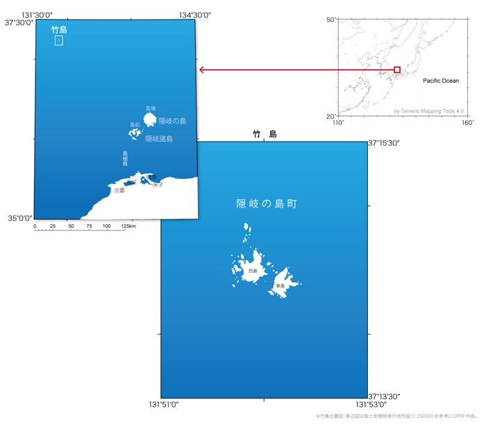
Takeshima is a collection of islets located 158km northwest of the Oki Islands, at 37°14’N and 131°52’E in the Sea of Japan. The territory consists of the Eastern islet (Mejima) and the Western islet (Ojima) as well as their surrounding reefs. The Eastern Islet’s highest point above sea level is 97m and that of the Western Islet is 168m (Ref.1). Takeshima is part of Okinoshima Town, Shimane Prefecture (Ref.2). The total surface area of Takeshima is approximately 0.21km2 (Ref.3). The survey conducted by the Shimane Prefectural Government in 1906 noted that Takeshima’s entire shoreline is comprised of cliffs and that these cliffs are particularly precipitous on the Western Islet. The survey also noted that the territory does not boast any conspicuous form of flora other than grasses. Studies confirmed that the Eastern Islet was formed by volcanic andesite, whereas the Western Islet consists of andesitic and basaltic tuff (Ref.4).
| Island | Latitude | Longitude | Height (Above Sea Level) |
|---|---|---|---|
| Eastern Islet(Mejima) | 37.241 | 131.870 | 97m |
| Western Islet(Ojima) | 37.242 | 131.865 | 168m |
* Longitude, latitude, and height (above sea level) were calculated by OPRF based on the Digital Japan Basic Map produced by the Geospatial Information Authority of Japan.
Takeshima’s Geology
The report from the 1906 Shimane Prefectural Government survey concerning Takeshima’s geology is still on file today. According to this report, the Eastern Islet does not boast a proper volcanic crater and was formed by andesite which erupted from an underwater volcano. The Western Islet’s geology is comprised of andesitic tuff. (Ref.4)
*The attached geological map indicates the Eastern Islet’s geology as comprising andesitic tuff and that of the Western Islet’s as andesite.
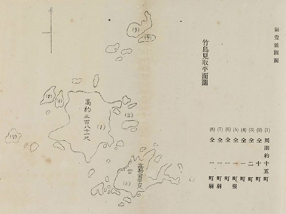
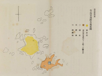
Figure: Geological map of Takeshima created based on inspection in 1909(from『竹島及鬱陵島』)

Ref. 1: Digital Japan Basic Map (Geospatial Information Authority of Japan)
Ref. 2: Geospatial Information Authority of Japan, topographical map 1:25000
Ref. 3: GIS and Land Area Information/ Areas of Prefectures and Municipalities in Japan for 2013 (Geospatial Information Authority of Japan) (Japanese only)
Ref. 4: H. Okuhara, Takeshima Oyobi Utsuryoto (Takeshima and Utsuryo), 1907

*Click the links to go to the individual pages.
Related Research

International Law and Japan's Territorial Disputes
Raul (Pete) Pedrozo (Feb 06, 2018)
The "Critical Date" of the Takeshima Dispute
MIYOSHI Masahiro (Jan 30, 2015)
The Meaning of the Territorial Incorporation of Takeshima (1905)
TSUKAMOTO Takashi (Dec 25, 2014)
The Late-Seventeenth-Century "Takeshima" Dispute, with Reference to the Dajokan Order of 1877
TSUKAMOTO Takashi (Aug 29, 2014)
Related Readings
TAKAHASHI Noritsugu (Sep 15, 2022)
Japan Coast Guard Activities On and Around Takeshima
HIROSE Hajime (Sep 22, 2017)
TSUKAMOTO Takashi (Sep 12, 2016)
Refutation of Korean Media Claims Regarding Japanese Maps of Takeshima(Part1)
FUNASUGI Rikinobu (Jul 08, 2015)
Info Library
Japan's Island Territories
Senkaku Islands Facts & Figures
Takeshima Facts & Figures
Northern Territories Facts & Figures