 RSS
RSSTopography of Uotsuri Island
-
Feb 17, 2015
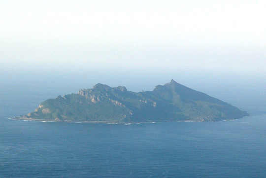
Uotsuri Island is an oval-shaped island with cuesta formations. On the south side of the island there are steep cliffs, and the land slopes gently down toward the north side. Water flows along more than 10 underground channels on bedding planes from south to north. Apart from a few areas with coral outcroppings, the coast is made up of either rocky reefs or cliffs. (Ref. 1)
The island is approximately 3.3 kilometers in length from east to west and 1.3 kilometers from north to south. The highest point of the island, at 362.0 meters, is near the south coast, rising above the cliffs a little way to the west, while the second highest peak (301.7 meters) is toward the east. Sheer cliffs more than 300 meters high stretch across the south coast. (Ref. 2)
In 1979, the Japanese government's Okinawa Development Agency conducted a survey regarding potential development and usage of Uotsuri Island, Kitakojima Island, and Minamikojima Island. This survey established geodetic control points, survey markers, and photo control points with the aim of preparing a 1:5000 scale map. (A water depth survey was completed at the same time.) The topographical map below was prepared based on the agency's survey. (Ref. 3)
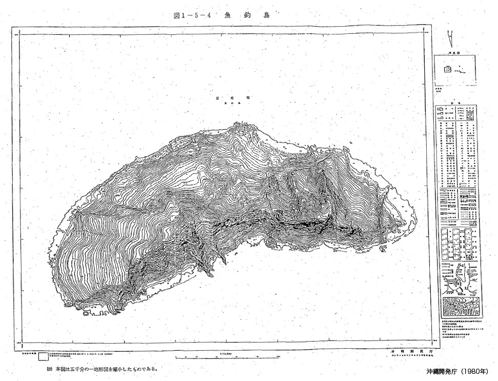
Source: Okinawa Development Agency, Senkaku Shoto chosa hokokusho: Riyo kaihatsu kanosei chosa hen (Report on the Senkaku Islands Survey: Potential Development/Usage Survey), 1980.

Ref.1 :Nohara Tomohide, "Senkaku Retto no chishitsu (yoho)" (Preliminary Report on Geology of the Senkaku Islands), in Senkaku Retto gakujutsu chosa hokoku (Report on the Senkaku Islands Scientific Expedition), based on a survey carried out by the University of the Ryukyus Scientific Expedition Team (Nishihara, Okinawa: University of the Ryukyus, 1971).
Ref.2 :Matsumoto and Hayashi, Chapter 4, in Senkaku Shoto chosa hokokusho: Gakujutsu chosahen (Report on the Senkaku Islands Survey: Academic Survey) (Okinawa Development Agency, 1980).
Ref.3 :Senkaku Shoto chosa hokokusho: Riyo kaihatsu kanosei chosahen (Report on the Senkaku Islands Survey: Potential Development/Usage Survey) (Okinawa Development Agency, 1980).

→
Related Research

U.S. Recognition of Japanese Sovereignty Over the Senkaku Islands
Raul(Pete)Pedrozo (Sep 15, 2022)
Protest and Acquiescence in Territorial Acquisition: In relation to the Senkaku Islands
MIYOSHI Masahiro (May 01, 2018)
International Law and Japan's Territorial Disputes
Raul (Pete) Pedrozo (Feb 06, 2018)
The Senkaku Islands as Viewed through Chinese Law
SAKAMOTO Shigeki (Sep 12, 2016)
Related Readings
TAKAHASHI Noritsugu (Sep 15, 2022)
TAKAI Susumu (Sep 15, 2022)
CHIBA akira (Sep 27, 2021)
Notes on David Helliwell's "The Clashing Rocks"
ISHIWI Nozomu (Sep 12, 2016)
Info Library
Japan's Island Territories
Senkaku Islands Facts & Figures
Takeshima Facts & Figures
Northern Territories Facts & Figures